Sharing press information about storm number 3 late afternoon on July 21.
The situation is changing rapidly, the storm tends to get stronger.
Speaking at the press conference, Mr. Mai Van Khiem, Director of the National Center for Hydro-Meteorological Forecasting, said: Compared to the bulletins released 3-4 days ago, when the storm was still active in the Western Pacific region and had just passed the Philippines, the storm's developments up to now have had many notable changes.
As soon as the storm entered the East Sea, the Center issued an early warning bulletin. However, at that time, there was still a difference between domestic and international forecast models regarding the storm's movement.
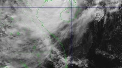
After entering the East Sea, storm No. 3 moved steadily northwest. By the evening of July 20, the storm approached the coastal area of Guangdong province (China), moving along the coastal strip of neighboring country, maintaining a level 12 intensity. However, by 9:00 a.m. on July 21, when entering the Gulf of Tonkin, the storm's intensity weakened to level 9 - a decrease of 3 levels in 12 hours, due to its trajectory shifting north and making landfall earlier than expected.
From noon to early afternoon on July 21, the storm tended to slightly shift southward, and its circulation was tightly reorganized. Satellite data and expert analysis showed that the storm showed signs of strengthening, reaching late level 9 and early level 10, up one level compared to the morning of the same day.
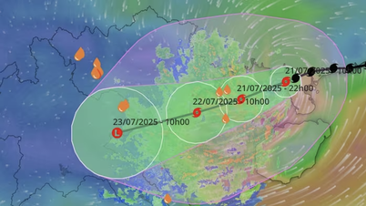
The storm is forecast to continue to strengthen, possibly reaching late level 10 or early level 11 when it approaches the sea area from south of Hai Phong to north of Thanh Hoa from late morning to early afternoon of July 22.
According to Mr. Mai Van Khiem, the circulation of storm No. 3 is very wide. Since the evening of July 20, although it has not yet entered the Gulf of Tonkin, this area has had widespread rain. In the provinces of the Northern Delta, including the capital Hanoi , scattered rain has also been recorded due to the influence of the storm cloud edge.
From noon to afternoon of July 21, heavy rain increased in the Northeast region, especially Quang Ninh province with common rainfall of 100mm - 175mm, in some places nearly 200mm. Strong winds began to appear on outpost islands such as Bach Long Vi.
As of the afternoon of July 21, the storm's center was about 130km east-northeast of Bach Long Vi Island. Observations showed strong winds of level 8, gusting to level 9. Tonight and early tomorrow morning, this area may record winds of level 9-10, gusting to level 11, which is a development that requires special attention.
From the night of July 21 to the morning of July 22, the coastal area of Quang Ninh will be affected first by strong winds (level 9-10 offshore, level 7-8 onshore). After that, the circulation will expand, affecting the Northeast and the Northern Delta.
Heavy rains will increase sharply in the Northern Delta and North Central regions, concentrated from the early morning of July 22. The strongest wind on land is expected to occur from south of Hai Phong to north of Thanh Hoa between 10am and 3pm on July 22, coinciding with the storm's landing. Winds may reach level 8-9, near the storm's eye level 10, gusting to level 13.
Important warning, do not be subjective with risk scenarios
The National Center for Hydro-Meteorological Forecasting identified three areas at risk of being most severely affected:
Outpost islands such as Bach Long Vi, Co To, and Cat Hai are recording winds of level 6-8 and will continue to be directly affected on the night of July 21 and the morning of July 22.
Coastal areas of Quang Ninh - Hai Phong face strong winds, big waves, high tides, and risk of flooding in low-lying areas.
The Northern Delta and North Central regions from Hai Phong to Nghe An, where prolonged heavy rain combined with strong winds is forecast, pose a risk of flash floods, landslides and urban flooding.
In addition, Hung Yen and Ninh Binh provinces, although not bordering the sea, are in the indirect affected area. The Center has compiled a list of high-risk communes and wards in Hung Yen, Ninh Binh, Thanh Hoa, and Nghe An to serve the response work.
In Quang Ninh, rainfall was nearly 200mm on July 21 and continued to increase. The western regions of Thanh Hoa and Nghe An were also on high alert, with nearly 70 communes under flash flood and landslide monitoring.
Notably, this phenomenon does not only occur during heavy rains but can also appear after rains, especially in mountainous districts such as Muong Lat (Thanh Hoa). In addition, heavy rains in Upper Laos can increase water flow to rivers and streams in northern Vietnam, causing late floods.
It is forecasted that from 1pm to 5pm on July 22, wave heights at coastal stations such as Ba Lat (Thai Binh), Hoang Chau (Hai Phong), Cua Ong and Tra Co (Quang Ninh) may reach 2.4m - 5m. The combination of storms, big waves and high tides increases the risk of coastal flooding.
Mr. Khiem also said that although the current trajectory of the storm is consistent with the official forecast, the Center still warns that the worst scenario cannot be ruled out: the storm will slow down, deviate to the South - Southwest, prolong its activity in the Gulf of Tonkin and may strengthen.
"Compared to storm Yagi (2024), storm No. 3 has a weaker intensity, but a wider circulation range, heavier rainfall and longer duration. Total rainfall in the North, Thanh Hoa and Nghe An is forecast to be 250mm - 400mm, in some places over 600mm, a high danger level, requiring the initiative of all levels, sectors and people," Mr. Khiem shared.
The northern mountainous region and the North Central region continue to be warned of a high risk of flash floods and landslides - especially in areas that are often overlooked but heavily affected when natural disasters occur. The focus of this warning is: the mountainous areas of western Thanh Hoa, Nghe An, southern Phu Tho, Hoa Binh, western Son La and Quang Ninh, where the terrain is steep, the soil is weak, and landslides are likely to occur when heavy rains last for a long time.
Although the Northern mountainous region is not in the main rain area, the wide storm circulation can create thunderstorms causing localized rain at the outer edge of the circulation, a factor that needs special attention, because short thunderstorms on the mountain slopes can easily lead to sudden flash floods.
Currently, the flash flood and landslide warning system of the National Hydrometeorological Service has been upgraded online at: sanat.co.vn. This system provides early warnings 3-6 hours before an incident occurs, updated hourly, based on observed and forecasted rainfall data. Warnings are divided into three risk levels (medium, high, very high), shown in clear colors, supporting the authorities and people to proactively respond.
The Center for Hydro-Meteorological Forecasting recommends that press agencies coordinate to widely communicate about the online warning system, helping people recognize risks in their living places, thereby having appropriate prevention plans to minimize damage.
According to NDĐT
Source: https://baoquangtri.vn/bao-so-3-dien-bien-phuc-tap-hoan-luu-rong-tac-dong-som-den-khu-vuc-bac-bo-196061.htm







![[Photo] National Assembly Chairman Tran Thanh Man visits Vietnamese Heroic Mother Ta Thi Tran](https://vphoto.vietnam.vn/thumb/1200x675/vietnam/resource/IMAGE/2025/7/20/765c0bd057dd44ad83ab89fe0255b783)









Comment (0)