
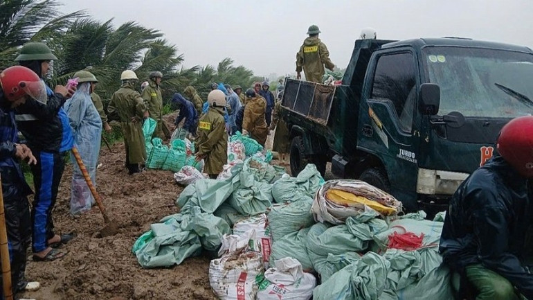
Specifically, 7 houses had their roofs blown off or were damaged; more than 2,000 hectares of rice were broken; more than 136 hectares of crops and vegetables were flooded and collapsed (corn, cassava, peanuts, vegetables, etc.); 2 cows, 5 pigs and 3,050 chickens and ducks were swept away; 7 hectares of traditional fish farming area were flooded and overflowed...
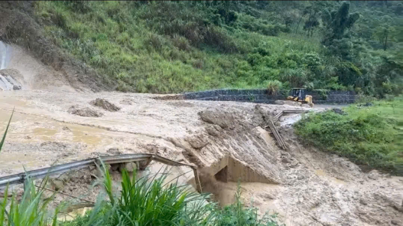
Regarding the dike project: The dike slope collapsed on the west side of the Cung River dike (small river dike, level 4) from K5+858 to K5+905 in Hoang Chau commune with a length of about 47m; The section from K5+959-K5+976, with a landslide length of 18m, a landslide depth of 2m and a vertical height of 2m and an incident with the Vuc Buu culvert on the right dike of Nhom River, a flow appeared along the culvert, causing 2 sinkholes on the top of the culvert and sinking deep into the culvert. After discovering the incident, local authorities mobilized human resources, materials and means according to the "4 on-site" motto to handle the incident; at the same time, they set up markers and placed warning signs of danger within the landslide area, widely announced on the mass media; and did not allow people and vehicles to enter the dangerous area.
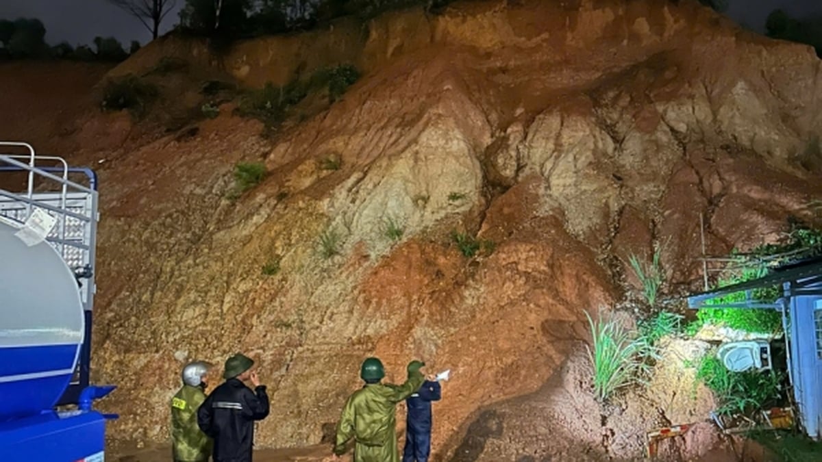
On National Highways: National Highways 15C and 16 had landslides on the positive slope, sedimentation of ditches and culverts at 8 locations with a volume of about 20,270m3, including 1 location at Km77+700/National Highway 15C causing traffic jam; subsidence and cracks on the road surface at 1 location/National Highway 45 with a length of 5m; broken retaining wall at 1 location/National Highway 15 with a length of 5m.
On provincial roads: Flooded roads at 14 locations causing traffic jams: Flooded roads at Km2+829/DT.505B Thang Binh commune, flooded 0.5m deep; Cao Khanh Flooded Road at Km11+050/DT.518 Quy Loc commune, flooded 0.2m deep; Cua Du Flooded Road at Km22+550/DT.519B Luan Thanh commune, flooded 0.6m deep; Road section Km56+100 - Km56+200 Thang Loc commune, Van Xuan commune, flooded 1.3m deep; Thanh Nang Flooded Road at Km32+00/DT.519B Tan Thanh commune, flooded 0.4m deep; Flooded Road at Km37+900-Km38+00/DT.519B Tan Thanh commune, flooded 0.5m deep; Song Quyen Flooded Road at Km0+900/DT.520B Hoa Quy commune, flooded 0.4m deep; Hang Hy spillway Km1+600/DT.523B Cam Tu commune, flooded depth is 0.1m; Ha Tan 6 spillway Km17+250/DT.522B Tong Son commune, flooded depth is 0.2m; Vot spillway Km18+250/DT.523B Quy Luong commune, flooded depth is 0.3m; Mo Tom spillway Km19+300/DT.523B Quy Luong commune, flooded depth is 0.6m; Spillway Km8+600/DT.523C Thach Binh commune, flooded depth is 0.25m; Tan Lap spillway Km18+200/DT.530B Tam Van commune, flooded depth is 0.3m. Negative slope landslide at 2 locations/DT.521 with a length of about 32m. Positive slope landslides and rolling rocks occurred at 11 locations/DT.521C with a volume of about 948m3. 3.6. In addition, 2 low-voltage electric poles were knocked down and broken; 1 ferry was sunk; 1 garage collapsed and damaged; 1 auxiliary structure was damaged, 60m of fence collapsed...
Currently, irrigation construction companies have operated 49 pumping stations and 199 pumps to drain floodwaters from residential areas, roads, production facilities, and protect crops. The Department of Agriculture and Environment of Thanh Hoa province has also established many working groups to directly go to mountainous areas to direct and supervise storm response work; guide the implementation of tasks and solutions for natural disaster prevention and control; inspect and supervise the drainage and protection of agricultural production.
The Chairman of Thanh Hoa Provincial People's Committee also issued Official Dispatch No. 09/CD-UBND requesting localities, enterprises exploiting irrigation works, Thanh Hoa Electricity and related units to immediately deploy drainage plans, especially drainage for agricultural production, preventing flooding in residential areas, industrial parks, and traffic routes. Directing urgent operations, mobilizing maximum capacity of drainage pumping stations and drainage sluices to drain water and buffer water, protecting flooded rice and crop areas; continuously patrolling and clearing blockages in the drainage axis and canals, ensuring rapid drainage. The Head of the Management Board of Nghi Son Economic Zone and Industrial Parks, the Director of the Department of Agriculture and Environment, and the Director of the Department of Construction shall direct the immediate implementation of flood control and prevention plans according to their assigned functions, tasks, and areas/areas. The Directors of the Companies: Irrigation Works Exploitation, Environment Joint Stock Company, and Thanh Hoa Urban Works shall direct the maximum mobilization of human resources and equipment to operate pumping stations, drainage culverts, and dredge and clear drainage canals and drainage shafts. The Director of Thanh Hoa Electricity Company shall direct the assurance of continuous and safe power supply for the operation of pumping stations and drainage culverts. The provincial leaders also requested the Chairmen of the People's Committees of communes and wards in the delta and coastal areas to direct the disaster prevention and control task force and related forces in the area to immediately implement plans to drain water, clear and clear drainage canals and drainage shafts under their management.
Source: https://cand.com.vn/Xa-hoi/bao-so-3-gay-nhieu-thiet-hai-cho-tinh-thanh-hoa-i775673/


![[Photo] National Assembly Chairman attends the seminar "Building and operating an international financial center and recommendations for Vietnam"](https://vphoto.vietnam.vn/thumb/1200x675/vietnam/resource/IMAGE/2025/7/28/76393436936e457db31ec84433289f72)


Comment (0)