
At this time, the center of the tropical depression is located on the mainland of Ninh Binh and Thanh Hoa provinces, at coordinates of about 20.1 degrees North latitude and 105.7 degrees East longitude. The strongest wind near the center of the tropical depression is at level 7, gusting to level 9. In the next 3 hours, the tropical depression will hardly move.
Previously, at 5:00 p.m. on July 22, storm No. 3 remained at level 8, gusting to level 10, and in the next 3 hours, the storm barely moved. Meteorological experts said this was a rare phenomenon. The storm was almost stationary, with strong winds of level 7-8 continuing to be recorded in many places.
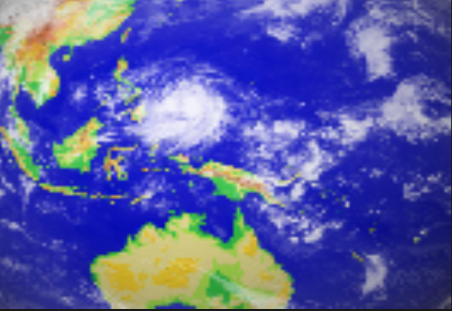
Specifically, Hon Dau ( Hai Phong ): level 8, jerk level 10; Uong Bi (Quang Ninh): level 7, jerk level 8; Van Ly (Ninh Binh): level 8, jerk level 10; Ba Lat (Hung Yen): level 7, jerk level 9...
The National Center for Hydro-Meteorological Forecasting predicts that in the next 24 hours, the storm will continue to move in a West-Southwest direction at a speed of 10-15km/hour, enter the Upper Laos region and gradually weaken into a tropical depression, then a low pressure area.
From the night of July 21 to July 22, storm No. 3 (Wipha) caused many prolonged heavy rains in many localities in the southern part of the Northern Delta and especially the North Central region (Thanh Hoa and Nghe An ).
Source: https://cand.com.vn/doi-song/bao-so-3-suy-yeu-thanh-ap-thap-nhiet-doi-sau-khi-do-bo-vao-dat-lien-7-tieng--i775650/


Comment (0)