

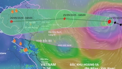
Forecast in the next 3 hours, the storm moves west, speed about 20km/hour.
Forecast for the next 24-48 hours, until 13:00 on September 25, the storm will move west at about 20 km/hour, gradually weakening. Location at 21.6 degrees north latitude, 107.8 degrees east longitude, on the mainland east of Quang Ninh . Strong winds level 8-9, gusts level 11.
Danger zone north of latitude 19.5 degrees north, west of longitude 115.0 degrees east.
Disaster risk level: level 4 in the Northwestern part of the East Sea, level 3 in the northern Gulf of Tonkin and the Northeastern coast.
At 1 p.m. on September 26, the storm moved west at 20 km/h, weakened into a tropical depression, then a low pressure area. Location at 21.4 degrees north latitude, 103.3 degrees east longitude, on the mainland of the Northwest region of the North. Intensity < level 6.
Danger zone north of 20.0 degrees north latitude, west of 110 degrees north longitude.
Disaster risk level: level 3 in the northern Gulf of Tonkin and the northeastern coast.
Forecast of storm impacts causing strong winds, big waves, rising sea levels.
Northwest East Sea strong wind level 9 - 11, near the storm center level 12 - 14, gust level 17. Waves 7 - 9m high, rough sea.
Northeast of Bac Bo Gulf (including Bach Long Vy), wind level 6 - 7, gust level 9. From the night of September 24, North of Bac Bo Gulf (Bach Long Vy, Van Don, Co To, Cat Hai, Hon Dau), wind gradually increases to level 7 - 8, waves 2 - 4 m high, near the storm center level 9 - 11, gust level 13, waves 3 - 4.5 m, rough sea.
Quang Ninh coastal area has storm surge of 0.4 - 0.6 m. Boats anchored near the shore and aquaculture areas are strongly affected by wind, big waves and surge.
On land, from early morning of September 25, coastal areas from Quang Ninh to Hung Yen will see winds gradually increase to level 6 - 7, near the storm center level 8 - 9, gusting to level 11.
Inland Northeast wind level 5, some places level 6, gust level 7-8.
From the night of September 24 to the end of the night of September 26, the North, Thanh Hoa and Nghe An will have heavy to very heavy rain, with rainfall ranging from 150 - 300 mm, with some places experiencing over 450 mm. There is a high risk of urban flooding. From September 25 to 27, floods are likely to occur on rivers in the North, Thanh Hoa and Nghe An. The flood peak on the Thao River and other small rivers will reach alert levels 2 to 3.
Flood peaks on Lo River, upper Thai Binh River, Hoang Long, Buoi, and upper Ma River reached alert levels 1 to 2.
Risk of flash floods on small rivers and streams, landslides in mountainous areas.
Source: https://baolaocai.vn/bao-so-9-van-o-cap-14-cach-mong-cai-quang-ninh-470-km-post882832.html

![[Photo] Closing of the 1st Congress of Party Delegates of Central Party Agencies](https://vphoto.vietnam.vn/thumb/1200x675/vietnam/resource/IMAGE/2025/9/24/b419f67738854f85bad6dbefa40f3040)


![[Photo] Editor-in-Chief of Nhan Dan Newspaper Le Quoc Minh received the working delegation of Pasaxon Newspaper](https://vphoto.vietnam.vn/thumb/1200x675/vietnam/resource/IMAGE/2025/9/23/da79369d8d2849318c3fe8e792f4ce16)


![[Photo] Solemn opening of the 1st Congress of Party Delegates of Central Party Agencies](https://vphoto.vietnam.vn/thumb/402x226/vietnam/resource/IMAGE/2025/9/24/82a89e250d4d43cbb6fcb312f21c5dd4)


Comment (0)