According to the National Center for Hydro-Meteorological Forecasting, at 1:00 a.m. on July 19, the center of storm Wipha was located at about 19.7 degrees North latitude - 121.5 degrees East longitude, in the sea north of Lu Dong island. The strongest wind near the center of the storm was level 9 (75 - 88 km/h), gusting to level 11. It is forecast that in the next 24 hours, the storm will move in a West-Northwest direction at a speed of 20 - 25 km/h and enter the East Sea. The storm will strengthen to level 10 - 12, with rough seas.
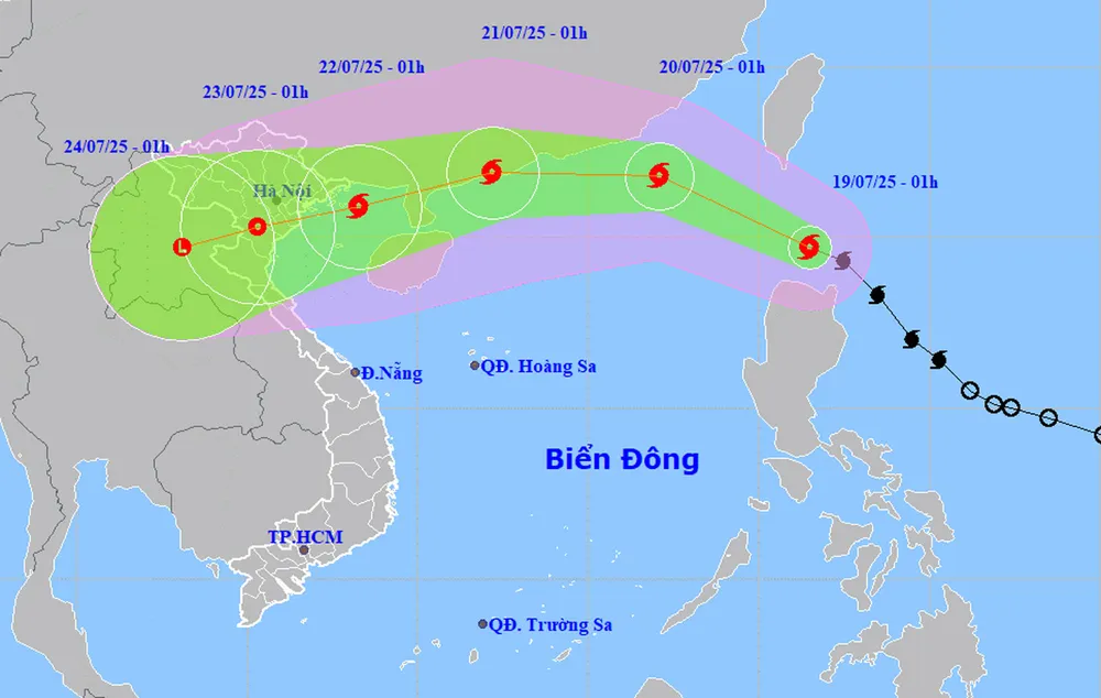
At 1:00 a.m. on July 20, the center of the storm was at about 21.8 degrees North latitude - 117.1 degrees East longitude, in the northeastern sea area of the North East Sea, about 760 km east of Leizhou Peninsula (China). The storm intensity increased to level 10, gusting to level 12. The dangerous area in the East Sea is determined from latitude 18 - 23 degrees North and east of longitude 116 degrees East. Natural disaster risk level is level 3.
By the early morning of July 21, the storm is likely to intensify to level 11 - 12, gusting to level 14, about 210 km east-northeast of Leizhou peninsula. After that, the storm will change direction to move west-southwest, gradually weakening when entering the Gulf of Tonkin on July 22 with intensity of level 9 - 10, gusting to level 13.
Due to the storm's influence, the northeastern sea area of the East Sea has strong winds of level 6-7, near the storm's center level 9-10, gusting to level 12. Waves are 3-5m high, and the sea is very rough. Ships operating in the danger zone are at high risk of being affected by tornadoes, strong winds, and large waves.
On the morning of July 19, at some coastal stations, strong gusts of wind were recorded, such as in Phu Quy special zone, the southwest wind was level 5, sometimes level 6, gusting to level 7; at Huyen Tran station, the wind was level 5 - 6, gusting to level 9. It is forecasted that during the day and tonight, the northern and central areas of the East Sea (including the Hoang Sa sea area), the Gulf of Tonkin, the Gulf of Thailand and the sea area from Ca Mau to An Giang will continue to have thunderstorms, tornadoes and gusts of level 6 - 8, waves over 3m high.
The sea area from Lam Dong to Ho Chi Minh City and the Truong Sa sea area will have southwest winds of level 6, gusting to level 7-8; waves from 2-4m high. Meanwhile, the sea area from South Quang Tri to Quang Ngai is forecast to have gusting to level 7-8 on the night of July 19.
In addition to the storm, heat waves continued to cover the North and Central regions on July 19. Temperatures in the Northeast were generally 35 - 36 degrees Celsius, some places above 36 degrees Celsius, low humidity 55 - 60%. From Thanh Hoa to Da Nang and the East of Quang Ngai to Khanh Hoa, temperatures were generally 35 - 37 degrees Celsius, some places exceeding 37 degrees Celsius. The Northwest also recorded many localized heat waves.
Some localities recorded high temperatures above 38 degrees Celsius, including Son Tay (Hanoi) 38.8 degrees Celsius, Son Dong (Bac Giang) 38.4 degrees Celsius, Bac Me (Tuyen Quang) and Cho Ra (Thai Nguyen) both reaching 38.2 degrees Celsius. Do Luong (Nghe An) alone reached 38.2 degrees Celsius.
It is forecasted that on July 20, the western mountainous region from Nghe An to Hue, Da Nang and Khanh Hoa will continue to experience severe heat. However, from July 21, the heat in the Central region will tend to ease. The risk level of natural disasters due to heat is assessed at level 1.
Faced with the complicated developments of storm Wipha and extreme weather at sea and on land, coastal localities and people need to regularly monitor weather forecasts and proactively prevent tornadoes, strong winds and heat waves.
Source: https://www.sggp.org.vn/bao-wipha-tien-vao-bien-dong-bien-dong-du-doi-post804421.html





![[Photo] Da Nang: Hundreds of people join hands to clean up a vital tourist route after storm No. 13](https://vphoto.vietnam.vn/thumb/1200x675/vietnam/resource/IMAGE/2025/11/07/1762491638903_image-3-1353-jpg.webp)





























Comment (0)