
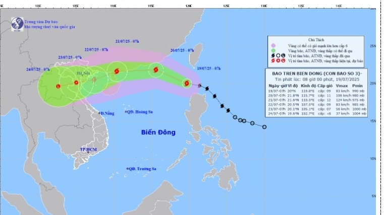
According to the Hai Phong City Hydrometeorological Station at 7:00 a.m. this morning, July 19, the storm center was at about 20.0 degrees North latitude; 119.8 degrees East longitude. The strongest wind near the storm center reached level 9 (75 - 88 km/h), gusting to level 12. The storm moved northwest at a speed of 20 km/h.
It is forecasted that in the next 24 to 72 hours, the storm will continue to move in a West Northwest direction, then turn West and West Southwest, traveling about 20 km per hour.
It is forecasted that on the morning of July 20, the storm may reach level 10-11, gusting to level 13, about 600 km east of Leizhou Peninsula (China).
On the morning of July 21, the storm approached the eastern coast of Leizhou peninsula, level 11-12, gusting to level 14.
On the morning of July 22, the storm entered the Gulf of Tonkin, gradually weakening to level 9, gusting to level 12.
The dangerous area at sea in the coming days is from latitude 18.0 to 23.0 degrees North and east of longitude 108.5 degrees East.
It is forecasted that from July 21 to 22, the Gulf of Tonkin, including the Hai Phong sea area, may be affected by strong winds of level 6-7, near the storm center level 8-9, then increasing to level 10-11, gusting to level 13. Waves 4-6 m high, rough seas. Ships operating in the area should quickly find safe shelter.
PVSource: https://baohaiphongplus.vn/bao-wipha-vao-bien-dong-chinh-thuc-tro-thanh-con-bao-so-3-hai-phong-chu-dong-ung-pho-416693.html
![[Photo] Editor-in-Chief of Nhan Dan Newspaper Le Quoc Minh received the working delegation of Pasaxon Newspaper](https://vphoto.vietnam.vn/thumb/1200x675/vietnam/resource/IMAGE/2025/9/23/da79369d8d2849318c3fe8e792f4ce16)


![[Photo] Prime Minister Pham Minh Chinh chairs the 14th meeting of the Steering Committee on IUU](https://vphoto.vietnam.vn/thumb/1200x675/vietnam/resource/IMAGE/2025/9/23/a5244e94b6dd49b3b52bbb92201c6986)


Comment (0)