I. NATURAL CONDITIONS
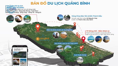
Quang Binh is located in the Central strip of Vietnam in the Northern Truong Son ecological region, with coordinates from 17°05' to 18°05' North latitude and between 106°59' and 107°10' East longitude, bordering Ha Tinh province to the North, Quang Tri province to the South, Khammouane and Savannakhet provinces of the Lao PDR to the West with a border length of 201.87 km, and the East Sea to the East with a coastline of 116.04 km. Quang Binh is located on the middle route of strategic trans-Vietnam routes such as National Highway 1A and Ho Chi Minh Road, the North-South Railway, 450 km south of Hanoi, and about 1,200 km north of Ho Chi Minh City. National Highway 12A runs from East to West through Cha Lo International Border Gate and Provincial Road 20 through Ca Roong Border Gate connecting to Lao PDR, one of the gateways connecting to countries in the Southeast Asian region.
Quang Binh province has a natural area of 8,065.27 km2, of which 85% is mountainous. The province's land resources are divided into two main systems: Alluvial soil in the plains and feralit soil in the hills and mountains with 15 different types. The entire area is divided into 04 different ecological regions: highland, hilly and midland, plain and coastal sand. Each ecological region contains many potentials and prospects for investment and development.
Quang Binh is a relatively narrow strip of land with a sloping terrain from the West to the East. The mountainous area on the eastern slope of the Truong Son range has an altitude of 250 m to 2,000 m with many dense forests and rugged mountains. Phi-co-pi (Giang Man) peak, bordering the Lao PDR, is the highest mountain in the province (2,071 m).
Located in the tropical monsoon zone, Quang Binh is always affected by the mixed climate of the North and the South and is divided into two distinct seasons: the rainy season from September to March of the following year; the dry season from April to August. The rainy season is often accompanied by storms and floods, the dry season causes drought. Quang Binh is located in an area with high rainfall, averaging from 2,000 to 2,500mm/year. The high mountainous area bordering Vietnam - Laos has rainfall up to 3,000mm/year, for example in Minh Hoa district.
High rainfall, a large number of rainy days and evenly distributed throughout the year have created ideal humid conditions for a typical limestone mountain rainforest system of exceptional global value.
Quang Binh has a forest area of 486,688 hectares, most of which is natural forest. Forest cover reached nearly 67.4% (in 2010), ranking second in the country in terms of forest cover, after Bac Can province. The forest has high timber reserves and many rare species of flora and fauna. Most of the mountainous area of Quang Binh is located in the Northern Truong Son ecological region, which is home to a diverse and unique flora and fauna system with many rare genetic resources, typical of the model of conservation of biodiversity values such as the Phong Nha - Ke Bang karst area (PN-KB) and the lowlands of the Dong Chau - Khe Nuoc Trong area.
The World Natural Heritage PNPKB in Quang Binh has a unique forest type not found anywhere else on earth: evergreen tropical forest mainly coniferous with the dominant species of Calocedrus rupestris and under the canopy are Paphiopedilum spp. orchids distributed on limestone mountains at an altitude of over 700 - 1,000m. In addition, the National Park also has 15 identified forest types that have brought diversity to ecosystems, of which the evergreen forest type on limestone mountains is considered to be of international importance.

PNKB National Park is a typical example of the values of limestone mountain ecosystems in the world, of global significance for biodiversity conservation. Up to now, the presence of 2,953 species of vascular plants, 1,394 species of animals, with 823 species of vertebrates and 393 species of insects have been identified. Most of them are indigenous species in the region. There are up to 121 species of plants and 116 species of animals listed in the HHBTTNQT Red Book 2006, 28 species of animals and plants with high economic and scientific value are threatened at the global level. Many rare animals are listed in the Vietnam Red Book and the World Red Book such as animals such as Ha Tinh langur, saola, large-antlered muntjac, pheasants of various kinds...; plants such as hương mộc, lim, gụ lau, tau, lát hoa, bach xanh...; Under the forest canopy, there are also plants with high economic value such as rattan, agarwood, precious medicinal herbs such as Bo Chinh ginseng, seven-leaf one-flower ginseng, cardamom, Gynostemma pentaphyllum, blood grass...
The diversity of limestone mountain habitats, caves, and dirt mountains... are ideal conditions for 9/21 primate species (43% of Vietnam's primates) to live and distribute in Quang Binh. There are 3 globally endangered primate species: Hatinh Langur (Trachypithecus hatinhensis), Red-shanked Douc Langur (Pygathrix nemaeus) and White-cheeked Crested Gibbon (Nomascus leucogenys siki), of which Hatinh Langur is a narrow endemic species found only in limestone mountains in PNKB National Park and neighboring areas. The vast area of limestone mountains and primary forest vegetation has created conditions for the bat fauna here to develop the most diversely in Vietnam, with 46 species (accounting for 43% of the total number of species in Vietnam), making it one of the places with the greatest potential in Vietnam and the world for bat species conservation.

PNKB National Park is also an important site for the conservation of endemic species, with 419 endemic plant species of Vietnam, 41 endemic animal species of the Truong Son range, of which 23 species are only found in PNKB.
Quang Binh has 05 main river systems, including the Roon River, Gianh River, Ly Hoa River, Dinh River and Nhat Le River systems. Rivers are the traffic arteries connecting the mountainous areas with the plains, rural areas and urban areas. The river and stream systems create diverse ecological basins. In particular, the province has 02 large river mouths, Gianh and Nhat Le, serving socio-economic development, contributing to expanding trade and integration.
Quang Binh's coastline stretches with many blue-green beaches next to overlapping white and yellow sand dunes, dotted with rocky shores with spectacular landscapes, typically Da Nhay beach on Ly Hoa pass, Bo Trach district. The continental shelf is 2.6 times larger than the mainland, forming a large fishing ground, with seafood reserves of about 99,000 tons with 1,659 species, including many rare species such as lobster, tiger prawn, squid, and cuttlefish. In the north of the province, at the foot of Ngang pass, there is Hon La deep-water bay and many small islands convenient for ships to anchor. Hon La has been invested in and built to become a deep-water seaport with great prospects for economic development.
Quang Binh province has many valuable minerals such as gold, iron, titanium, limestone, kaolin, quartz. Of which, limestone and kaolin have large reserves, sufficient conditions to develop the cement and construction materials industry on a large scale. In the province, there are 03 mineral spring mines, of which the most prominent is Bang hot spring in Le Thuy district with a hot spot of up to 105°C, which has been built into a majestic resort.
II. SOCIAL AND CULTURAL CONDITIONS
Since ancient times, Quang Binh has been known as the economic, cultural and social intersection between the three regions of North - Central - South and has a long-standing historical and cultural tradition. Archaeological sites discovered in this land show the interweaving of cultural elements of Dong Son - Sa Huynh, Dang Trong - Dang Ngoai, Thang Long - Phu Xuan. That interweaving gradually developed into a unified trend in the development stages of Quang Binh's history.
In the development process of national history, Quang Binh not only has a long history but this land has also experienced many ups and downs. In almost every period, Quang Binh has had to stand at the forefront of the country as a sacred mission" (Nguyen Khac Thai, 2002). And to undertake that historical mission, the people of Quang Binh have bravely and steadfastly devoted their human and material resources to the cause of building and defending the country, leaving behind many movements and many names that are famous in history books.
Historical documents also show that Quang Binh is in an important position on the path of formation and development of the nation. Thousands of years ago, Quang Binh was a part of the Viet Thuong Department, one of the 15 departments of Van Lang country during the Hung Kings' era. During the following centuries, our country was occupied by Chinese feudal dynasties, turning it into their districts. The small land of Quang Binh sometimes belonged to Cuu Chan district under Trieu Da's reign, sometimes it was in Nhat Nam district under the Han Dynasty. From the first century AD, Quang Binh was a border area of a powerful country in the South, with a geographical area stretching from Nam Hoanh Son to the southernmost part of the Central region, which was the Lam Ap country (later called La Hoan Vuong, Chiem Thanh, Champa). This factor contributed to the diversity and richness of Quang Binh's cultural history. The Champa Kingdom built many military citadels here, traces of which still remain today, such as: Hoan Vuong Citadel (in Quang Trach district), Ke Ha Citadel (Bo Trach district), and Ngo Dynasty Citadel (Le Thuy district).
In 1069, Ly Thuong Kiet led his army to expand the territory to the South, taking back the three regions of Bo Chinh, Dia Ly and Ma Linh. From then on, the land of the old Viet Thuong department (including Quang Binh) returned to Dai Viet territory. In 1075, Ly Thuong Kiet reformed the border management system to deal with hostile forces, expanded the southern land of the Fatherland, recruited people to establish villages, and planned maps. From then on, Quang Binh existed stably in the heart of Dai Viet Nation.
In the following centuries, from the Tran Dynasty (1225-1400), Ho Dynasty (1400-1407), Later Tran Dynasty (1407-1419), Early Le Dynasty (1428-1527), Mac Dynasty (1527-1529), Later Le Dynasty (1533-1788), successive dynasties expanded their territories, migrated to reclaim and live on new lands from the South of Ngang Pass. In 1604, for the first time in history, Lord Nguyen established a direct administrative unit in Dia Ly Chau called Quang Binh Prefecture. From then on, the name Quang Binh was born and exists until today.
During that historical period, Quang Binh witnessed the Trinh - Nguyen civil war that lasted for more than 2 centuries, the Gianh River was used as the boundary dividing Dang Trong and Dang Ngoai. From Ngang Pass to Ha Co - the narrowest strip of land in the country became a tragic battlefield. In 1788, Emperor Quang Trung marched for the second time, wiped out 290,000 Manchu troops, and unified the country. The disaster of dividing the Gianh River ended from then on. Under the Nguyen Dynasty, the land of Quang Binh was established as an independent administrative unit under the court named Dinh Quang Binh, until 1831, King Minh Mang officially established the administrative unit named Quang Binh province.
In 1858, the French and Spanish East Asian fleets opened fire on Da Nang, starting the war of invasion. After the fall of Hue, Ton That Thuyet took King Ham Nghi to Son Phong (Quang Tri), issued the Can Vuong edict calling on scholars and people to help the king save the country. After that, King Ham Nghi went to the western mountains of Quang Binh to build a resistance base against French colonialism. People in many localities in Quang Binh responded to the "Can Vuong" movement, joined the resistance forces against the French and made many achievements that are recorded in history.
On July 19, 1885, French colonialists invaded Quang Binh. The army and people of Quang Binh heroically rose up with the army and people of the whole country to seize power in 1945 and then waged a resistance war to drive out the French, winning complete victory in 1954.
Peace had not lasted long when the US sent troops to Vietnam (1964 - 1972). From then on, Quang Binh became the front line in the resistance war against the US. The people of Quang Binh contributed human and material resources, endured many losses and sacrifices to join the people of the whole country in liberating the South and reunifying the country.
Since returning to Dai Viet, Quang Binh land has changed its name many times: Lam Binh (1075), Tan Binh (1375), Tay Binh (1402), Tien Binh (1600), Quang Binh prefecture (1604), Quang Binh province (1831) and finally Quang Binh province under the Democratic Republic since 1945.
During the Nguyen Dynasty, there appeared famous people who made Quang Binh land famous such as: Duong Van An, Nguyen Huu Hao, Nguyen Ham Ninh... Quang Binh land also contributed to the country talented people whose names are recorded in history books such as: Le Thanh Marquis Nguyen Huu Canh - who had the merit of reclaiming and establishing a whole land in the South of the Fatherland; Vo Nguyen Giap, a talented general - a great cultural figure in the Ho Chi Minh era.
In 1976, the three provinces of Quang Binh, Quang Tri and Thua Thien merged into Binh Tri Thien province. On July 1, 1989, Quang Binh province was re-established, returning to its original boundaries and name in history.
Regarding administrative organization, Quang Binh has 06 districts: Tuyen Hoa, Minh Hoa, Quang Trach, Bo Trach, Quang Ninh, Le Thuy, 01 Ba Don town and 01 Dong Hoi city under the province.
The total population of the province by 2019 was 895,423 people, mostly Kinh people (accounting for over 97% of the population). The ethnic minority community in Quang Binh includes 02 main ethnic groups: Chut, Bru - Van Kieu and some groups of Muong, Thai, Tay... with 26,296 people (accounting for about 2.94% of the province's population). The ethnic minority community mainly resides in the highlands, quite isolated in the valleys along rivers and streams, where there are favorable water sources and quite fertile land in the West of Quang Binh.
Religions in Quang Binh are mainly Buddhism and Catholicism. Some ancient pagodas, temples, and shrines worshiping folk gods have been restored and become spiritual and cultural activities that are of interest to locals and tourists, such as: Pho Minh Pagoda (Duc Ninh Commune, Dong Hoi City), Non Pagoda on the top of Than Dinh Mountain (Truong Xuan Commune, Quang Ninh District), Lieu Hanh Princess Temple at the foot of Deo Ngang Pass (Quang Dong Commune, Quang Trach District), and Hoang Phuc Pagoda in Le Thuy District.
Catholicism was introduced to Quang Binh around 1619 - 1820. There are still many Catholic churches in the villages along Gianh River (in Quang Trach district) and Son River (Bo Trach district).
Quang Binh has cultural values that have been passed down from generation to generation. The treasure of Quang Binh folk culture is diverse, rich and unique, including: Folk literature, folk culture - arts, traditional festivals, customs and practices. Every region in Quang Binh has folk cultural activities that are imbued with the identity of the homeland such as: Dum singing, Sac Bua singing, Thuoc singing in Minh Hoa; Kieu singing, Nha Tro singing, Nhan Ngai singing, Hui singing in Quang Trach; Bong Cheo Can dance, Cau Mua festival in Dong Hoi, Khoan singing, rice pounding singing, verses, and Ly in Le Thuy, Bai Choi festival, March Full Moon festival in Minh Hoa, Drum Beating festival of the Bru - Van Kieu people in Thuong Trach commune, Bo Trach district.
As a land where the great cultures of the country intertwine and exchange, Quang Binh has had a unique cultural identity since ancient times. This has contributed to building a rich spiritual life. This is also the driving force that helps Quang Binh people overcome the ups and downs of history and the difficulties and challenges that always arise in every era.
According to Quang Binh Cave Wonders
Provincial Information Portal


![[Photo] Politburo works with the Standing Committee of Lai Chau Provincial Party Committee](https://vphoto.vietnam.vn/thumb/1200x675/vietnam/resource/IMAGE/2025/9/4/f69437b9ec3b4b0089a8d789d9749b44)
![[Photo] Prime Minister hands over decisions on receiving, transferring and appointing leaders of ministries and agencies](https://vphoto.vietnam.vn/thumb/1200x675/vietnam/resource/IMAGE/2025/9/4/b2445ecfd89c48bdb3fafb13cde72cbb)
![[Photo] Politburo works with the Standing Committee of the Party Committee of the Fatherland Front and Central organizations](https://vphoto.vietnam.vn/thumb/1200x675/vietnam/resource/IMAGE/2025/9/4/6f23e5c0f576484bb02b3aad08f9d26a)
![[Photo] Prime Minister Pham Minh Chinh chairs the thematic meeting on law making in August 2025](https://vphoto.vietnam.vn/thumb/1200x675/vietnam/resource/IMAGE/2025/9/4/ba42763cd48e4d7cba3481640b5ae367)
![[Photo] Politburo works with the Standing Committee of Can Tho City Party Committee](https://vphoto.vietnam.vn/thumb/1200x675/vietnam/resource/IMAGE/2025/9/4/10461762301c435d8649f6f3bb07327e)






































Comment (0)