
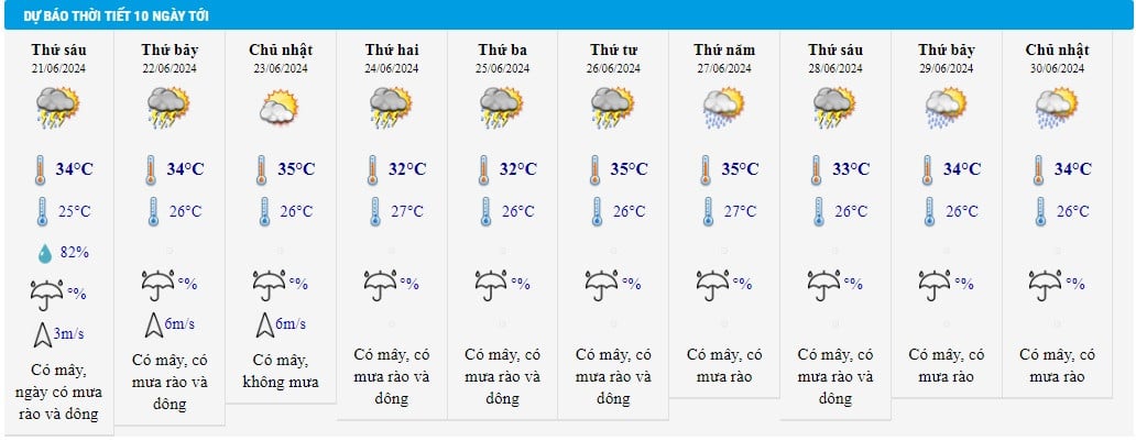
According to the National Center for Hydro-Meteorological Forecasting, last night and this morning (June 21), in the mountainous areas of the North, South Central, Central Highlands and South, there will be showers and thunderstorms, locally heavy to very heavy rain.
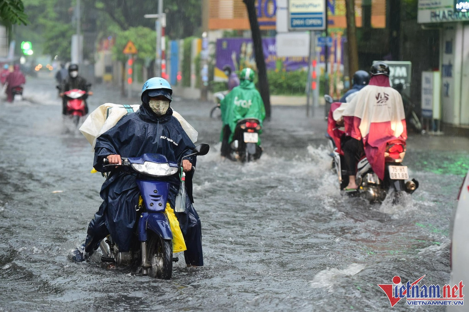
Rainfall from 7pm on June 20 to 8am on June 21 was over 70mm in some places such as: Tan Lap (Ha Giang) 435.2mm, Nhat Tien (Lang Son) 150.2mm, Quang Tan ( Dak Nong ) 75.4mm, Duc Hoa (Long An) 106.8mm, Nha Be (Ho Chi Minh City) 76mm,...
From now until tomorrow (June 22), in the Central Highlands and the South, there will be moderate rain, heavy rain and thunderstorms, locally very heavy rain with common rainfall from 40-80mm, some places over 150mm; moderate rain, heavy rain mainly concentrated in the afternoon and night.
In addition, this evening and tonight, the Northern region will have scattered showers and thunderstorms, locally heavy rain with rainfall from 15-30mm, some places over 70mm.
Today and tonight, the area from Quang Ngai to Binh Thuan will have showers and thunderstorms, locally heavy to very heavy rain with rainfall from 20-50mm, some places over 80mm.
The period of showers and thunderstorms, with localized heavy to very heavy rain in the South Central, Central Highlands and Southern regions, is likely to last until around June 23.
Meanwhile, the heat wave continues in the North and Central regions. Today, from Thanh Hoa to Thua Thien Hue, there is heat and severe heat, some places are especially severe with the highest temperature commonly ranging from 36-39 degrees, some places above 39 degrees; the lowest relative humidity commonly ranges from 40-45%.
The midlands and deltas of the North, Hoa Binh and from Da Nang to Quang Ngai are hot, with some places experiencing severe heat with the highest temperature commonly ranging from 35-37 degrees, some places above 37 degrees; the lowest relative humidity commonly ranges from 50-55%.
Weather forecast for June 21, 2024 in regions across the country:
Hanoi weather
Cloudy, hot during the day, scattered showers and thunderstorms in the evening and at night. Southeast to south wind level 2-3. Thunderstorms are likely to cause tornadoes, lightning, hail and strong gusts of wind.
Lowest temperature: 27-29 degrees.
Highest temperature: 35-37 degrees.
Northwest
Cloudy, sunny during the day, especially in Hoa Binh where it is hot and sunny, with some places experiencing intense heat. In the evening and at night, there will be scattered showers and thunderstorms, with some heavy rain. Light wind. During thunderstorms, there is a possibility of tornadoes, lightning, hail and strong gusts of wind.
Lowest temperature: 25-28 degrees; in the Northwest region, some places are below 24 degrees.
Highest temperature: 31-34 degrees; Hoa Binh 35-37 degrees, some places over 37 degrees.
Northeast
Cloudy, sunny during the day, especially in the midlands and plains, hot and sunny in some places, with severe heat in some places, scattered showers and thunderstorms in the evening and at night, locally heavy rain. Southeast to south wind level 2-3. During thunderstorms, there is a possibility of tornadoes, lightning, hail and strong gusts of wind.
Lowest temperature: 26-29 degrees, mountainous areas below 25 degrees.
Highest temperature: 31-34 degrees; midlands and plains 35-37 degrees, some places above 37 degrees.
Thanh Hoa - Thua Thien Hue
Cloudy, hot and very hot during the day, especially very hot in some places, showers and thunderstorms in the evening and at night. Southwest wind level 2-3. During thunderstorms there is a possibility of tornadoes, lightning, hail and strong gusts of wind.
Lowest temperature: 28-31 degrees.
Highest temperature: 36-39 degrees, some places above 39 degrees.
Da Nang to Binh Thuan
In the North, it is cloudy, hot during the day, with some places experiencing intense heat, with scattered showers and thunderstorms in the afternoon and at night; in the South, it is cloudy, with scattered showers and thunderstorms, with some heavy rain. Southwesterly winds level 2-3. During thunderstorms, there is a possibility of tornadoes, lightning, hail and strong gusts of wind.
Lowest temperature: 26-29 degrees.
Highest temperature: North 35-37 degrees, some places above 37 degrees; South 31-34 degrees.
Central Highlands
Cloudy, with showers and scattered thunderstorms in the afternoon and at night, locally heavy to very heavy rain. Southwesterly winds level 2-3. Thunderstorms are likely to produce tornadoes, lightning, hail and strong gusts of wind.
Lowest temperature: 21-24 degrees.
Highest temperature: 28-31 degrees, some places above 32 degrees.
Southern Vietnam
Cloudy, with showers and scattered thunderstorms in the afternoon and at night, locally heavy to very heavy rain. Southwesterly winds level 2-3. Thunderstorms are likely to produce tornadoes, lightning, hail and strong gusts of wind.
Lowest temperature: 25-28 degrees.
Highest temperature: 31-34 degrees.
HCMC weather: Cloudy, showers and thunderstorms during the day, highest temperature 34 degrees.
Weather at sea today, in the Central and Southern East Sea (including the waters of the Truong Sa archipelago), the waters from Binh Dinh to Ca Mau, Ca Mau to Kien Giang and the Gulf of Thailand will have showers and strong thunderstorms. During thunderstorms, there is a possibility of tornadoes and strong gusts of wind of level 7-8, beware of wave heights sometimes increasing to over 2m.
The sea area from Binh Thuan to Ca Mau and the western sea area of the South China Sea (including the western sea area of Truong Sa archipelago) has strong southwest winds of level 5, sometimes level 6, gusting to level 7-8; rough seas; waves from 1.5-3m high.
Source: https://vietnamnet.vn/du-bao-thoi-tiet-21-6-2024-tay-nguyen-nam-bo-co-noi-mua-to-tren-150mm-2293707.html


![[Video] More than 100 universities announce tuition fees for the 2025–2026 academic year](https://vphoto.vietnam.vn/thumb/1200x675/vietnam/resource/IMAGE/2025/7/18/7eacdc721552429494cf919b3a65b42e)


![[Infographic] In 2025, 47 products will achieve national OCOP](https://vphoto.vietnam.vn/thumb/402x226/vietnam/resource/IMAGE/2025/7/16/5d672398b0744db3ab920e05db8e5b7d)


Comment (0)