
(HNMO) - On June 10, the Department of Science and Technology of Ho Chi Minh City informed that a group of scientists from the Southern Hydrometeorological Station has completed a city-level scientific research task on using artificial intelligence (AI) to forecast urban flooding.
The scientific project is entitled “Research, construction and pilot implementation of an urban flood early warning system based on artificial intelligence in Ho Chi Minh City”. Master Le Ngoc Quyen is the project manager. The project has been accepted by the Department of Science and Technology of Ho Chi Minh City.
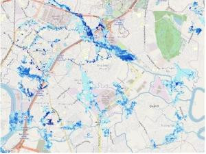
During more than 2 years of implementing the mission, the group has successively carried out major tasks, including: Establishing a big data system on flooded areas, flood levels, and flood duration (in all 3 forms of flooding caused by heavy rain, flooding caused by high tides, and flooding caused by heavy rain combined with high tides) over the past many years in Ho Chi Minh City. Then, the group used the "machine learning" method to "teach" AI to analyze and determine how much rain there will be, for how long; how high the tide will rise, which areas will be flooded, for how long...
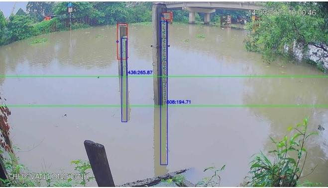
In particular, the team also uses the "visual analysis" method so that AI can receive images from traffic and security cameras, photos taken by people at the scene and send them to the system to recognize and assess, forecast the direction of flooded areas, flood levels and flood time.
As a result, the team has completed the function of a high-resolution (3km), short-term (0-6 hours, maximum 24 hours) rain forecasting system and water level forecasting in Ho Chi Minh City.
In practice, AI has helped the system make quite good forecasts of heavy rains occurring in the Southern region, Ho Chi Minh City and Thu Duc City. In particular, the team has "trained AI using the RainNet model to calculate and estimate rain from Nha Be radar images with data using the rainy months, from May to November, updated every 10 minutes to make forecasts.
Master Le Ngoc Quyen said that estimating rainfall from radar images using AI is very important for very short-term forecasting, while monitoring the movement of cloud masses through estimated rainfall. Combining methods, the group has completed a rain forecasting system that combines AI technology forecasting for the first 3 hours and WRF model forecasting for the next hours up to the end of 24 hours in each area quite accurately.
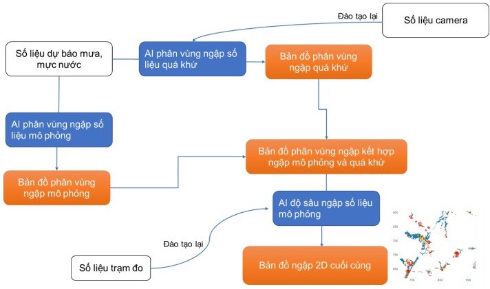
“The team has built 1,188 possible future flood scenarios in the research area; at the same time, set up a website and applications on all smart handheld devices to notify flood forecast maps, rain forecasts and flood warnings to users when a certain flooded location exceeds the threshold according to the user's route settings (radius of 5km). We are ready to coordinate with other parties to deploy this application according to the needs of users”, Master Le Ngoc Quyen informed.
Source


Comment (0)