

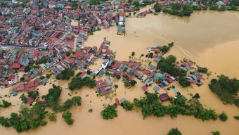
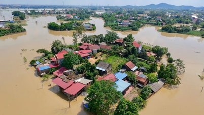
Due to the floodwaters from the upstream (Thai Nguyen, Lang Son) flowing downstream, many places in Bac Ninh province and the north of Hanoi have been flooded. By the morning of October 10, the flood on the Cau River flowing through Hanoi (formerly Soc Son area) and the Ca Lo River remained at a high level, exceeding alert level 3 by 1.5 to more than 2 meters.
According to the Northern Hydrometeorological Station, the flood peak appeared on the night of October 9, and the water level is currently falling slowly.
Cau River originates from the former Bac Kan mountainous region (now Thai Nguyen), flows through Thai Nguyen and Bac Ninh provinces and then enters Hanoi (at Soc Son) before converging with Ca Lo River and pouring into the Duong River system.
The Ca Lo River originates from Phu Tho province, flows through Soc Son area (Hanoi) and then joins the Cau River. Floodwater from these two rivers has caused flooding in many communes in the North of Hanoi since October 9th.
This morning, October 10, many low-lying areas in the North of Hanoi such as Da Phuc, Thu Lam, Phuc Thinh, Quang Minh, Tien Thang, Noi Bai are still flooded from about 0.3 to 0.6m deep (or higher). However, in some places, the water has receded since yesterday afternoon due to floods overflowing into low-lying areas.
 on the afternoon of October 9. Photo cut from clip")
According to the Northern Hydrometeorological Station, flooding in communes north of Hanoi may last another 3-4 days, due to the very slow drainage process.
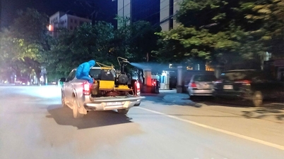
 move pigs as floodwaters flow in. Photo: Contributor")
Yesterday, October 9, the Ministry of Agriculture and Environment requested Tuyen Quang Hydropower Company to reopen and open the bottom spillway gate of Tuyen Quang hydropower reservoir after several days of closing it to cut floods.
Updated data from the system of Vietnam Electricity Group up to 6:30 am this morning, October 10, Tuyen Quang power plant is opening 3 bottom spillway gates (total discharge flow is nearly 2,500m3 /second.
The Northern Hydrometeorological Station said that after Tuyen Quang Lake opened more bottom spillway gates, the water level of Lo River and Gam River in Tuyen Quang and Phu Tho provinces will rise again above alert level 2, possibly affecting the downstream area (Hanoi) in the coming days.
Source: https://www.sggp.org.vn/ha-noi-lu-dat-dinh-co-the-ngap-them-3-4-ngay-post817235.html

![[Photo] "Exposing letters" in the flood center of Lang Son](https://vphoto.vietnam.vn/thumb/1200x675/vietnam/resource/IMAGE/2025/10/10/1760080117518_ndo_br_z7101324112737-07cd4d1c01801a8ccf4ae0cbaf31c4a3-507-jpg.webp)
![[Photo] Prime Minister Pham Minh Chinh attends the Patriotic Emulation Congress of Hanoi city](https://vphoto.vietnam.vn/thumb/1200x675/vietnam/resource/IMAGE/2025/10/10/1760078918257_dsc-2008-jpg.webp)


![[Photo] Standing member of the Secretariat Tran Cam Tu works with the Standing Committee of the Party Committee of the Ministry of Health](https://vphoto.vietnam.vn/thumb/1200x675/vietnam/resource/IMAGE/2025/10/10/1760079818773_image-4-6972-jpg.webp)


![[Photo] President Luong Cuong presents decisions on conferring titles and appointing Vietnamese Ambassadors](https://vphoto.vietnam.vn/thumb/402x226/vietnam/resource/IMAGE/2025/10/10/1760082105623_image-1.jpeg)


Comment (0)