

Km 304+350 of National Highway 16 was completely blocked due to thousands of cubic meters of rock and soil sliding down from the mountain - Photo: Nghe An Department of Construction
According to the Vietnam Road Administration ( Ministry of Construction ), on the evening of July 24, a working delegation from the Vietnam Road Administration directly inspected the work of overcoming the consequences of storm No. 3 (storm Wipha) and floods to ensure road traffic in Nghe An province.
National Highway 7 and National Highway 16 still have hundreds of flooded and landslide spots.
Mr. Le Canh Tam, Director of Joint Stock Company 495 (the unit that maintains this route) said that the unit manages 225 km of National Highway 7. According to preliminary statistics, the entire route currently has 51 flooding and landslide spots on both positive and negative slopes, many of which are traffic jams.
The unit mobilized 13 excavators and dozens of officers and workers divided into many teams to ensure traffic safety and to clear mud and soil, initially clearing a section of the road. By the evening of July 24, from Dien Chau up, the unit had cleared traffic to Km148.
On the evening of July 24, when the water receded, the road force's machinery was able to reach the landslide site to clear the mud and soil. Before that, there were many locations with deep water, and motorbikes could not access the construction site. Currently, in the Tuong Duong and Ky Son areas, there are many sections without electricity or phone signal, so communication is very difficult.
On National Highway 16, passing through Nhon Mai Commune (formerly Tuong Duong District), at Km 304+350 National Highway 16, thousands of cubic meters of rock and soil from the mountain slid down, completely blocking this unique road, causing a complete traffic jam. The unit that maintains the section is Trung Tin Joint Stock Company. According to preliminary statistics, the storm has caused 18 landslides on the positive and negative slopes. Currently, the unit is mobilizing 2 large-capacity excavators and more than 10 other excavators divided into many teams to clear the rock and soil in order to clear the road as soon as possible.
"However, the weather is still raining heavily and this is a unique route, with high mountains on one side and deep ravines on the other. The construction site is very narrow, making it difficult to mobilize vehicles and excavators. In addition, due to power outages and phone signal outages, it is still impossible to contact the company's people who are on the route from Km307 to Km353," said a representative of Trung Tin Company.

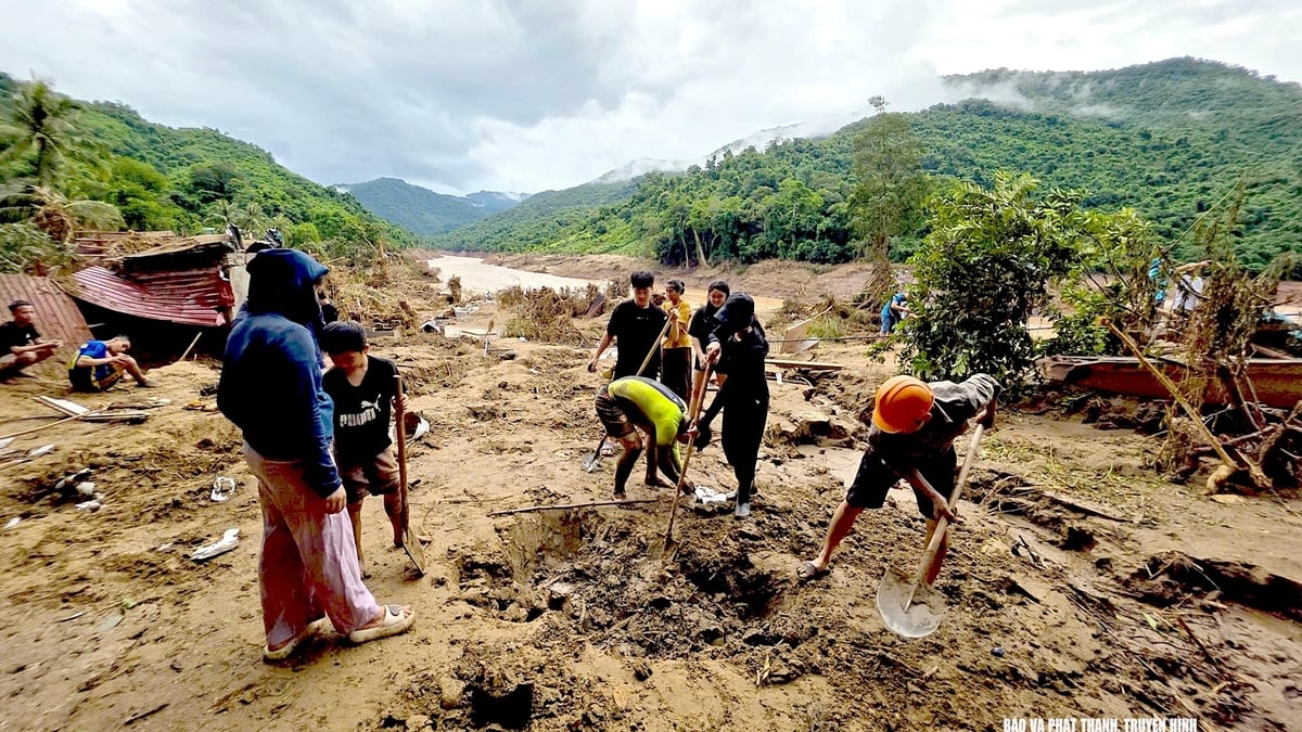
In the process of clearing landslides, in addition to the difficulties caused by narrow and inaccessible construction sites, the team of engineers and workers also faced danger as landslides continued to occur on the mountain.
Determined to clear the road as soon as possible
Mr. Ho Ba Thai, Deputy Director of Nghe An Department of Construction, added that storm No. 3 and heavy rains caused prolonged heavy rains, causing floods on rivers in Nghe An to rise, causing severe damage to people and traffic infrastructure in many localities of Nghe An province. The traffic system was severely damaged by storm No. 3 and heavy rains. Of which, Nghe An had 291 landslides and floods on national highways, provincial roads, and 3 suspension bridges were washed away.
To ensure the safety of people and vehicles, Nghe An Department of Construction has directed units to maintain the guardrail, set up barriers, and organize traffic safety at affected locations. At the same time, it mobilized maximum machinery and vehicles to level and clear the road as soon as possible, at least one lane.
Mr. Nguyen Thanh Hoai, Deputy Director of the Vietnam Road Administration, said: National Highway 7 and National Highway 16 are two extremely important routes to access and provide relief to areas severely damaged by storms and floods in the old Tuong Duong and Ky Son localities. Therefore, the task is to clear the roads as quickly as possible so that rescue and relief forces can reach the affected areas as soon as possible.
Nghe An Department of Construction needs to direct units to increase machinery and equipment to speed up progress. In locations where there are no landslides and safety is ensured, work all night, 24/7. Coordinate with local authorities and local functional forces to access and grasp the situation at locations without electricity or phone signal. Road Management Area II provides maximum support for human resources, machinery, equipment and spare materials for Nghe An province to quickly overcome the damage caused by storms and floods.

Floods continue to separate and isolate many residential areas
For more information, Nghe An Department of Construction said that since the night of July 24, a large crack has appeared in the Xang Tren mountain area (My Ly commune). Upon inspection, the crack is more than 100m long, looping through many points in the village, with a high risk of landslides. On the night of July 24 and the morning of July 25, the authorities evacuated households at the foot of the mountain and dangerous areas to a safe place. My Ly commune authorities are setting up monitoring posts, sending people on duty and advising people not to return home until there is a safety notice.
According to updated information from the National Center for Hydro-Meteorological Forecasting, many localities in Nghe An are at risk of flash floods, landslides, and land subsidence in the coming time.
In the past 6 hours (from 10:00 p.m. on July 24 to 4:00 a.m. on July 25), the provinces of Lai Chau , Lao Cai and Nghe An had moderate rain, heavy rain, and some places had very heavy rain such as: Nam Manh 114.2mm, Nam Hang 2 106mm ( Lai Chau ), Phin Ngan 95.8mm, Ban Lien 64.4mm, Yen The 51.4mm (Lao Cai), Tuong Duong 21.6mm (Nghe An),... The soil moisture model shows that some areas in the above provinces are nearly saturated (over 85%) or have reached a saturated state.
Rain warning for the next period: In the next 3-6 hours, the above provinces will continue to have rain, with common accumulated rainfall as follows: Lai Chau and Lao Cai provinces from 20-50mm, some places over 100mm; Nghe An from 10-20mm, some places over 50mm.
Warning level of natural disaster risk due to flash floods, landslides, land subsidence due to heavy rain or water flow: Level 1. Floods on Ca River are at alert level 3.
Warning of the impact of flash floods, landslides, and land subsidence due to heavy rain or water flow: Flash floods and landslides can have very negative impacts on the environment, threatening people's lives; causing local traffic congestion, affecting the movement of vehicles; destroying civil and economic works, causing damage to production and socio-economic activities.
The Department of Dyke Management and Natural Disaster Prevention (Ministry of Agriculture and Environment) said that as of 9:00 p.m. on July 24, Nghe An province still had 24 isolated communes with 196 villages/18,087 households/79,683 people, of which 2 communes were completely isolated; 22 communes were partially isolated. In addition, nearly 1,900 houses in the flood-hit area were still flooded.
In the face of severe flooding, on July 23 and 24, a Government working delegation chaired by Deputy Prime Minister Mai Van Chinh inspected and directed flood response and recovery work in Nghe An province.
On the morning of July 24, the Ministry of National Defense mobilized helicopters to carry out emergency relief missions for isolated people. Accordingly, Nghe An province organized 2 working groups to inspect and direct the work of overcoming the consequences, coordinating with the Ministry of National Defense to supply 6 tons of instant noodles, 4 tons of milk, 6 tons of dry food, and 4 tons of water by helicopter to isolated communes. Thanh Hoa province organized to handle 4 dike incidents, put up warning signs and regulate traffic at 92 landslide locations on roads.
Phan Trang
Source: https://baochinhphu.vn/quyet-tam-thong-tuyen-ql7-ql16-nhanh-nhat-de-cuu-tro-dong-bao-102250725134932776.htm


Comment (0)