
According to the National Center for Hydro-Meteorological Forecasting, currently (March 17), a cold air mass is moving southward from the North.
Forecast of cold air movement on land around the night of March 18, this cold air mass will affect the Northeast region and some places in the Northwest; from March 19, it will affect other places in the Northwest, North Central and some places in the Central Central. Wind direction will change to Northeast inland level 2-3, coastal areas level 4-5.
From March 19, the weather in the North will turn cold, from the night of March 19, the weather in the North Central region will turn cold. During this cold air mass, the lowest temperature in the North will be from 15-18 degrees Celsius, in mountainous areas from 12-15 degrees Celsius, in high mountainous areas below 10 degrees Celsius; in the North Central region, the temperature will be from 16-19 degrees Celsius.
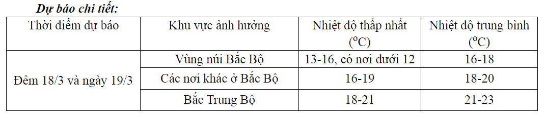
Weather forecast for March 18 and 19.
At sea: from the night of March 18, in the Gulf of Tonkin, the wind will change direction to Northeast and gradually increase to level 6, sometimes level 7, gusting to level 8, rough seas, waves from 1.5-2.5m high. From March 19, in the North East Sea, the wind will gradually increase to level 6, sometimes level 7, gusting to level 8-9, rough seas, waves from 2.0-4.0m high.
Warning of possible natural disasters: From the night of March 18-19, the Northern and North Central regions will have scattered showers and thunderstorms, with some heavy rain. From the afternoon of March 19, the area from Quang Binh to Phu Yen will have rain, showers and thunderstorms in some places. Thunderstorms may include tornadoes, lightning, hail and strong gusts of wind.
During these 3 months, the whole country may experience dangerous weather phenomena such as thunderstorms, tornadoes, lightning, hail and strong gusts of wind, especially during cold air waves affecting our country during the transitional season (April and May 2024).
From April, cold air activity is weak and there is little chance of severe cold. Light rain and drizzle also gradually decrease and only occur for a few days in the coastal areas of the Northeast.
In addition, the Meteorological Agency issued a bulletin forecasting storms, heat waves and severe heat waves nationwide from April to September 2024.
El Nino phenomenon
El Nino is a natural climate pattern caused by unusually warm waters in the eastern Pacific Ocean, formed when trade winds blowing from east to west along the equatorial Pacific slow or reverse as air pressure changes.
“La Nina” (also known as the Little Girl) is a phenomenon in which the surface water in the above-mentioned area cools abnormally, occurring with a similar or less frequent cycle than El Nino.
To express the contrast between these two phenomena, people sometimes use the concept of Anti-El Nino (opposite to El Nino). The La Nina phenomenon can appear right when the El Nino phenomenon weakens, but sometimes it is not so.
ENSO is an acronym for the El Nino Southern Oscillation (El Nino - Southern Oscillation) to refer to both El Nino and La Nina phenomena and is related to the oscillation of air pressure between the two shores of the Eastern Pacific Ocean and the Western Pacific - Eastern Indian Ocean (called the Southern Oscillation) to distinguish it from the air pressure oscillation in the North Atlantic).
Truc Chi (t/h)
Source


Comment (0)