
Latest news on storm No. 6 (storm Tra Mi), Mr. Nguyen Van Huong, Head of Weather Forecast Department, National Center for Hydro-Meteorological Forecasting said, due to the simultaneous impact of a cold air system and a newly formed storm circulation in the East of the Philippines, the direction of movement of storm No. 6 will continue to change abnormally.
Latest update on storm number 6 (storm Tra Mi)
According to Mr. Nguyen Van Huong, Head of Weather Forecast Department, National Center for Hydro-Meteorological Forecasting, on the afternoon of October 24, 2024, storm Tra Mi crossed the 120th meridian and entered the East Sea, becoming storm number 6.
At 4 p.m., the center of storm No. 6 was at approximately 17.3 degrees North latitude; 119.9 degrees East longitude, in the eastern sea of the North East Sea. The strongest wind near the center of the storm was level 9 (75-88 km/h), gusting to level 11. Moving westward at a speed of 15-20 km/h.
Where is storm number 6 going?
It is forecasted that within 48 hours, storm No. 6 will move mainly in a westerly direction, with an average speed of about 15km/h and a tendency to gradually strengthen. When moving to the eastern area of Hoang Sa archipelago, the intensity is likely to reach its strongest (level 12, gust level 15).
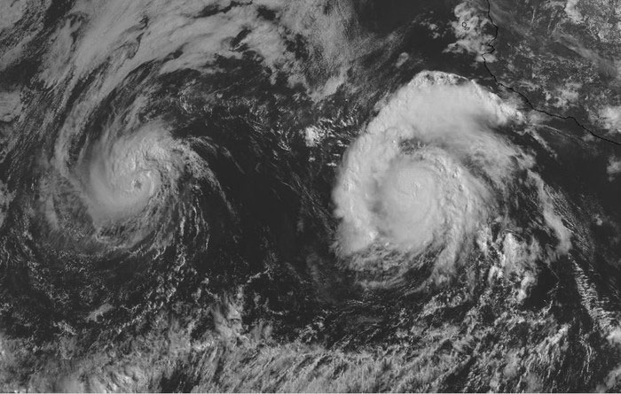
Due to the simultaneous impact of a cold air system and a newly formed storm circulation in the East of the Philippines, the movement direction of storm No. 6 - storm Tra Mi will continue to change abnormally. In the photo: The phenomenon of interference between 2 or more storms will occur when they form close together. Photo: NCHMF.
Possibility of unusual change?
According to Mr. Nguyen Van Huong, in the coming days, due to the simultaneous impact of the cold air system and the newly formed storm circulation in the East of the Philippines, the direction of movement of storm No. 6 will continue to have unusual changes, especially when passing through the Hoang Sa archipelago, reaching the sea off the Central coast.
"After October 26, storm No. 6 is likely to slow down, weaken and change direction. The possibility of making landfall is still unclear and needs to be monitored," said Mr. Huong.
Due to the complicated path of storm No. 2, Mr. Huong recommends the following immediate notes for the next 2 days: It is necessary to pay attention to the dangers of strong winds and large waves at sea, including in the northern and central areas of the East Sea, the sea area of Hoang Sa island district from today onwards will have strong winds of level 6-7, the area near the storm center will have levels 8-9, then will increase sharply as the storm intensifies; even the southern area of the East Sea is also affected by the strong southwest monsoon of level 6 causing rough seas.
The impact of strong winds on coastal areas will be monitored further in the next bulletin.
Source: https://danviet.vn/khan-them-mot-hoan-luu-bao-moi-hinh-thanh-duong-di-cua-bao-so-6-se-rat-kho-doan-20241024190333515.htm


Comment (0)