

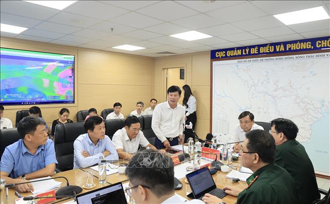
Ensuring safety on land and at sea
According to forecasts, in the early morning of September 23, the storm will enter the East Sea, in the morning of September 25, the storm will enter the Gulf of Tonkin with winds of level 9-10, gusts of level 13-14; in the afternoon and evening of the same day, the storm will make landfall with strong winds of level 8-9, gusts of level 11-12. Assessing this as the strongest storm in history when it makes landfall in the East Sea with strong winds of level 17 and above (super typhoon level), in order to proactively respond, ensure safety of people and property on land and at sea, and minimize damage caused by the storm, Deputy Minister Nguyen Hoang Hiep requested ministries, branches and localities to focus on early and remote implementation according to the direction of the Prime Minister in Official Dispatch No. 170/CD-TTg dated September 22.
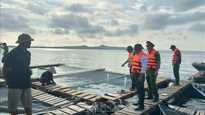
Deputy Minister Nguyen Hoang Hiep requested the Border Guard force to coordinate with the Ministry of Construction and localities affected by the storm to closely monitor the storm's developments; organize the counting and strict management of vehicles going out to sea; use all measures to notify owners of vehicles, captains of ships and boats operating at sea of the location, direction of movement and developments of the storm so that they can proactively avoid it, not move into dangerous areas or return to safe shelters. Depending on the developments of the storm, localities will decide on sea bans.
"According to forecasts, due to the impact of the storm, the Northern and North Central regions will have heavy rain. This is very worrying. Therefore, relevant ministries, branches and localities need to closely monitor the storm's developments to proactively respond to rain and manage inter-reservoirs (including irrigation and hydropower reservoirs). Along with that, it is necessary to pay attention to thunderstorms before, during and after the storm on land and at sea, to avoid cases like the one in Quang Ninh recently," Deputy Minister Nguyen Hoang Hiep emphasized.
Along with that, Deputy Minister Nguyen Hoang Hiep requested localities to proactively drain buffer water, prevent flooding to protect agricultural production, urban areas and industrial zones at risk of flooding; control and limit traffic during storms causing strong winds and heavy rains to limit incidents and ensure people's safety. Proactively organize the harvesting of agricultural products and aquaculture areas according to the motto "green house is better than old field".
The Department of Dyke Management and Natural Disaster Prevention and Control coordinates with the Department of Hydrometeorology and press agencies to provide the fastest disaster forecast and warning information to people so that they can proactively respond and minimize damage.
The National Center for Hydro-Meteorological Forecasting closely monitors storm developments, issues timely and realistic forecasts and warnings every 3 hours to serve the direction, operation and propaganda of storm response.
No sign of falling below level 17 in the next 6 hours
Regarding the storm situation, Associate Professor, Doctor, Director of the National Center for Hydro-Meteorological Forecasting Mai Van Khiem said that the storm cloud organization is developing, with no signs of decreasing below level 17 in the next 6 hours. On September 23, the wind intensity will remain at level 16-17.
Due to the influence of the storm circulation in the northern area of the East Sea, strong winds of level 8-9, then increasing to level 10-14, near the eye of the storm level 15-17, gusts above level 17, waves over 10m high, rough seas. From September 24, the sea area of the Gulf of Tonkin has strong storm winds of level 8, near the eye of the storm level 10-12, gusts level 15-16.
In the North East Sea, waves are 6-8m high, near the storm center, waves are very large, over 10m high. In the offshore area of Bac Bo Gulf (including Bach Long Vy special zone), waves are 2-4m high, near the storm center, waves are 5-7m high.
Coastal waters of Quang Ninh-Thanh Hoa provinces (including Van Don, Co To and Cat Hai special economic zones) have waves 2-4m high.
"The strongest storm winds are in the area from Quang Ninh - Thanh Hoa (coastal winds are strong at level 7-9, gusts 10-12, storm center at level 9-10, gusts 14, deeper inland winds are level 6-7, gusts 9-10). The period of strong winds is from the morning of September 25 to the night of September 25. If the storm moves further north, the impact of strong winds on the Gulf of Tonkin and the mainland will be less dangerous," Director Mai Van Khiem warned.
Mr. Mai Van Khiem stated that with the current forecast scenario of the storm moving, the heavy rain area will be the North and the area from Thanh Hoa - Ha Tinh with rainfall of about 70-150 mm. The rain center will be the provinces of Thai Nguyen, South Tuyen Quang, Lao Cai, Phu Tho; the Northern Delta, Thanh Hoa, Nghe An, Ha Tinh will have rain from 150-250 mm, locally over 450 mm.
Referring to the flood situation caused by storms, the Director of the National Center for Hydro-Meteorological Forecasting said that on the night of September 25-27, on rivers in the Northern region, from Thanh Hoa and Nghe An, there was a flood, the flood peak on the Thao River, Lo River, the upper Thai Binh River, and Hoang Long River reached alert level 1-alarm 2 and above alert 2; the lower Red River and Thai Binh River were still below alert 1. On small rivers, it reached alert level 2 - alert 3.
In Thanh Hoa area: Buoi River, upstream Ma River, Chu River at alert level 1- alert level 2 and above alert level 2, downstream Ma River at alert level 1.
The upstream of Ca River (in Nghe An) has reached alert level 1-2 and above alert level 2, the downstream of Ca River has reached alert level 1. High risk of flooding in low-lying areas along the river, urban areas, and densely populated areas in the provinces and cities of Thai Nguyen, Bac Ninh, Hanoi, Hung Yen, Ninh Binh, Thanh Hoa, Nghe An and flash floods and landslides on steep slopes in mountainous areas of the provinces from the North, from Thanh Hoa to Nghe An.
Proactive measures to respond to storms
At the meeting, Director of the Department of Dike Management and Natural Disaster Prevention and Control Pham Duc Luan requested localities to proactively take safety measures before the storm enters the East Sea and then the mainland, such as counting and ensuring the safety of boats, reviewing key areas to prepare plans and proactively evacuate people from unsafe houses, areas at risk of deep flooding, river mouths, and coastal areas; directing the work of ensuring the safety of sea dykes and river dykes, especially at vulnerable locations or those under construction.
Localities organize tree trimming; brace and reinforce signs, houses, public works, industrial parks, factories, warehouses, and projects under construction; check, review, and take measures to ensure the safety of telecommunications systems and power grid systems; and prepare forces, materials, and means to overcome the consequences immediately after the storm.
For mountainous areas, localities deploy shock forces to inspect and review residential areas along rivers, streams, low-lying areas at risk of flooding, flash floods, and landslides to proactively clear the flow of blocked and obstructed areas; proactively organize the relocation and evacuation of people in areas at risk to safe places, especially areas that have just experienced heavy rain; organize forces to guard, control, support, and guide to ensure safe traffic for people and vehicles, especially at culverts, spillways, deeply flooded areas, areas with fast-flowing water, areas where landslides have occurred or are at risk of landslides; resolutely not allow people and vehicles to pass if safety is not ensured; arrange forces, materials, and means to overcome incidents, ensuring smooth traffic on main traffic axes when landslides occur.
In addition, localities need to direct inspection, review, and prepare plans to ensure the safety of mines, reservoirs, and downstream areas, especially small reservoirs, vulnerable reservoirs, and reservoirs that are full of water; arrange permanent forces to operate and regulate and be ready to handle possible situations.
To respond to the storm, Major General Pham Hai Chau, Deputy Director of the Department of Rescue and Relief, General Staff, Vietnam People's Army informed: Currently, units in the area expected to be affected by the storm have prepared plans and strategies. More than 300,000 militia and self-defense officers and soldiers, 8,000 vehicles and six aircraft are ready to respond when situations arise.
The Ministry of National Defense has directed the Border Guard Command at sea routes to call, notify, and transmit information about the storm's direction. Currently, more than 54,000 vehicles and more than 200,000 fishermen have been called, counted, and instructed to know the storm's direction to take safe shelter.
Previously, the Prime Minister issued Official Dispatch No. 170/CD-TTg dated September 22, 2025 directing the Secretaries and Chairmen of the People's Committees of provinces and cities from Quang Ngai to the North and the Ministries and branches to deploy storm response measures with the most drastic spirit, early, from afar, proactively taking response measures at the highest level, anticipating the worst scenario.
On September 19, the National Civil Defense Steering Committee issued Document No. 03/BCĐ-BNNMT to the People's Committees of provinces and cities from Quang Ninh to Lam Dong on proactively responding to storm RAGASA near the East Sea.
The Ministries of National Defense, Construction, Industry and Trade, and Education and Training have issued telegrams directing storm response.
On September 22, 2025, the Consular Department (Ministry of Foreign Affairs) sent diplomatic notes to embassies of countries in the region requesting to create conditions for Vietnamese ships to take shelter and support rescue and repair of ships if necessary.
The National Center for Hydro-Meteorological Forecasting has issued a storm forecast bulletin since September 19 when the storm is near the East Sea; regularly updates the storm's developments to serve response direction.
The Department of Dyke Management and Natural Disaster Prevention and Control has organized a serious 24/7 duty, closely monitoring the developments of storms, strong winds at sea, local heavy rains, the situation of reservoirs and dykes to promptly advise on direction and response work; coordinated with Zalo Vietnam to send 7.8 million messages of recommendations and instructions on storm response skills.
News agencies and newspapers have closely followed and promptly reported on storm developments so that authorities at all levels and people can proactively respond...
Source: https://baotintuc.vn/xa-hoi/thu-truong-nguyen-hoang-hiep-chu-dong-ung-pho-mua-lon-do-bao-va-dam-bao-an-toan-ho-chua-20250922203741116.htm

![[Photo] Prime Minister Pham Minh Chinh chairs the 14th meeting of the Steering Committee on IUU](https://vphoto.vietnam.vn/thumb/1200x675/vietnam/resource/IMAGE/2025/9/23/a5244e94b6dd49b3b52bbb92201c6986)

![[Photo] Editor-in-Chief of Nhan Dan Newspaper Le Quoc Minh received the working delegation of Pasaxon Newspaper](https://vphoto.vietnam.vn/thumb/1200x675/vietnam/resource/IMAGE/2025/9/23/da79369d8d2849318c3fe8e792f4ce16)
![[Photo] The 1st Congress of Party Delegates of Central Party Agencies, term 2025-2030, held a preparatory session.](https://vphoto.vietnam.vn/thumb/1200x675/vietnam/resource/IMAGE/2025/9/23/e3a8d2fea79943178d836016d81b4981)
![[Photo] General Secretary To Lam meets voters in Hanoi city](https://vphoto.vietnam.vn/thumb/1200x675/vietnam/resource/IMAGE/2025/9/23/d3d496df306d42528b1efa01c19b9c1f)


Comment (0)