According to the National Center for Meteorological and Hydrological Forecasting, due to the influence of Typhoon Ragasa (Typhoon No. 9), the Bach Long Vi Special Economic Zone experienced strong winds of level 7, gusting to level 8.
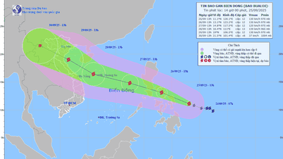
At 6:00 AM on September 25th, Typhoon Ragasa (Typhoon No. 9) was approximately 120km east of Mong Cai ( Quang Ninh ). The strongest winds near the center of the typhoon reached level 9 (75-88km/h), with gusts up to level 11. The forecast for the next 3 hours is that the typhoon will move westward at a speed of approximately 20km/h.
By 4 PM on the same day, Typhoon Ragasa (Typhoon No. 9) was over land in the Northeast region of Northern Vietnam, continuing to move westward at a speed of approximately 20 km per hour, gradually weakening into a tropical depression with maximum wind speeds of level 6, gusting to level 8.

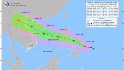
Map showing the predicted path and affected areas of Typhoon Ragasa (Typhoon No. 9). (Source: NCHMF)
At 4:00 AM on September 26th, the tropical depression over land in the Northwest region of Vietnam, moving westward at a speed of approximately 20 km/h, gradually weakened into a low-pressure area.
Due to the impact of Typhoon Ragasa (Typhoon No. 9), the northwestern sea area of the North East Sea will experience strong winds of force 6-8, gusting to force 10, with waves 3-5 meters high and rough seas.
In the northern Gulf of Tonkin (including the Bach Long Vy, Van Don, Co To, Cat Hai special zones and Hon Dau island), winds will be strong at level 6-7, with waves 2-3m high. Near the storm's center, winds will reach level 8-9, gusting to level 11, with waves 3-4m high, resulting in very rough seas.
Ships, boats, and aquaculture farms in the aforementioned hazardous zone are all severely affected by strong winds, high waves, and storm surges.
Inland, along the coastal areas from Quang Ninh to Hai Phong, winds will gradually strengthen to level 6-7, reaching level 8 near the storm's center, with gusts of level 9-10. Further inland in the Northeast, winds will be strong at level 5, reaching level 6 in some places, with gusts of level 7-8.
From early morning on September 25th until the end of the night of September 26th, Northern Vietnam, Thanh Hoa, and Nghe An will experience heavy to very heavy rain with rainfall amounts generally ranging from 150-300mm, and locally exceeding 450mm. Be prepared for heavy rainfall causing urban flooding.
In Hanoi, convective clouds are currently developing and causing rain in Kim Anh, Trung Gia, Thu Lam, and Da Phuc communes. These convective clouds will continue to move and expand into the inner city area.
Over the next 30 minutes to 3 hours, these convective clouds will bring thunderstorms to the aforementioned wards/communes, then spread to other wards/communes within Hanoi's inner city.
The meteorological agency warns that due to the wide-ranging influence of the storm's circulation, there is a risk of thunderstorms, tornadoes, and strong gusts of wind both before and during the storm's landfall.
Additionally, from September 25th to 27th, a flood is likely to occur on rivers in Northern Vietnam, Thanh Hoa, and Nghe An. Flood peaks on the Thao River and smaller rivers may reach alarm levels 2-3; flood peaks on the Lo River, the upper reaches of the Thai Binh River, the Hoang Long River, the Buoi River, and the upper reaches of the Ma River may reach alarm levels 1-2, with some rivers exceeding alarm level 2. Heavy rainfall poses a risk of flooding in low-lying areas; flash floods on small rivers and streams; and landslides on slopes.
Information on a new storm heading towards the South China Sea.
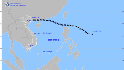
At 7 PM on September 24th, the center of Typhoon Bualoi was located at approximately 10.7 degrees North latitude and 131.0 degrees East longitude. The strongest winds near the center of the typhoon were at level 10 (89-102 km/h), with gusts up to level 12, moving in a west-northwest direction at a speed of 15-20 km/h.
Forecasts indicate that around the night of September 26th, Typhoon Bualoi will enter the eastern part of the central South China Sea, becoming the 10th typhoon of 2025.
Source: https://vtcnews.vn/tin-bao-so-9-ragasa-moi-nhat-giat-cap-11-cach-quang-ninh-120km-ar967303.html



![[Image] Nearly 125,000 Hanoi students completed the Literature exam for the 10th grade entrance exam.](https://vphoto.vietnam.vn/thumb/1200x675/vietnam/resource/IMAGE/2026/05/30/1780117233041_ndo_br_thiet-ke-chua-co-ten-2-png.webp)
































![[Photo] Admire the coral "masterpiece" amidst the million-year-old heritage of Dak Lak province.](https://vphoto.vietnam.vn/thumb/1200x675/vietnam/resource/IMAGE/2026/05/30/1780107638639_y25-jpg.webp)








































































Comment (0)