

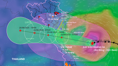
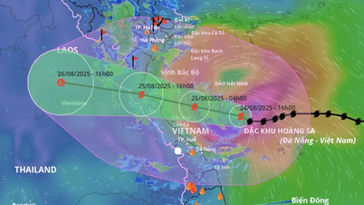
At 4:00 a.m. on August 24 , the center of the storm was located at about 17.6 degrees North latitude; 111.7 degrees East longitude, in the sea north of Hoang Sa special zone, about 660km East Southeast of Nghe An, about 640km East of Ha Tinh. The strongest wind near the center of the storm was level 12 (118-133km/h), gusting to level 15; moving west at a speed of about 20km/h.
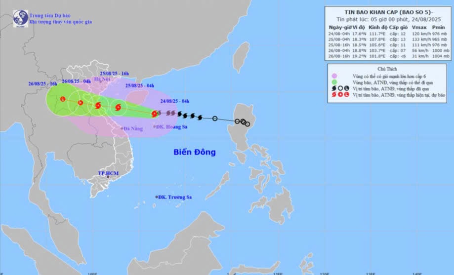
Storm development forecast ( in the next 24 to 60 hours ) :
| Forecast time | Direction , speed | Location | Intensity | Danger zone | Disaster Risk Level ( Affected Area ) |
| 04:00 August 25 | West Northwest, about 20km/h | 18.3N-107.8E; in the southern area of the Gulf of Tonkin; about 230km from Nghe An, about 210km from Ha Tinh to the East | 12-13, jerk 15; and can be stronger | Latitude 16.0N- 20.0N; longitude 106.5E- 114.5E | Level 3 : Western sea area of the North East Sea (including Hoang Sa special zone), Bac Bo Gulf, Southern sea area of Quang Tri-Hue City (including Hon Ngu island, Con Co special zone ) |
| 04:00 August 26 | West Northwest, 15-20km/h and gradually weakening | 18.8N-103.7E; in the Upper Laos area | 6-7, jerk 9 | Latitude 16.0N- 20.0N; West of longitude 108.5E | Level 3 : Gulf of Tonkin, sea area of Southern Quang Tri-Hue City (including Hon Ngu Island, Con Co special zone) Level 4 : Coastal waters from Thanh Hoa to Quang Tri, mainland provinces from Thanh Hoa to the north of Quang Tri |
| 4:00 p.m. August 26 | West Northwest, 15-20km/h and gradually weakens into a low pressure area. | 19.2N-101.8E; on land in Upper Laos | < level 6 | Latitude 16.5N- 20.0N; West of longitude 105.5E |
Forecast of storm impact : From noon and afternoon of August 24, the sea area of Nghe An province (including Hon Ngu island) will have winds gradually increasing to level 6-8, then increasing to level 9-10, near the storm center level 11-13, gusting to level 15; waves 4.0-6.0m high, near the center 7.0-9.0m. The sea will be very rough.
Coastal areas of Nghe An province have storm surges of 0.5-1.5m high. Water levels at Hon Ngu (Nghe An) are 3.5-4.0m high.
Warning : The weather at sea and in coastal areas during the storm is extremely dangerous and unsafe for any vehicles or structures operating in the danger zone such as: cruise ships, passenger ships, cargo ships, cages, rafts, aquaculture areas, dykes, embankments, coastal routes. Vehicles are at high risk of capsizing, destruction, and flooding due to strong winds, large waves, and rising sea levels.
On land : From the night of August 24, on land in Nghe An province , winds will gradually increase to level 7-9, near the storm center level 10-12, gusting to level 14-15.
From the night of August 24 to the end of August 26, in Nghe An province, there is a possibility of heavy to very heavy rain with common rainfall of 150-350mm, locally over 500mm. Warning of the risk of heavy rain (>200mm/3 hours).
Source: https://baonghean.vn/tin-moi-nhat-ve-con-bao-so-5-10305052.html


Comment (0)