
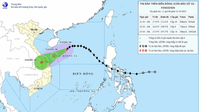
According to the Provincial Hydrometeorological Station, at 1:00 p.m. on October 20, the center of the storm was at about 18.3 degrees North latitude; 115.9 degrees East longitude, about 460 km East Northeast of Hoang Sa special zone. The strongest wind near the center of the storm was level 9-10 (75-102 km/h), gusting to level 12. Moving in the West Northwest direction, speed about 20 km/h.
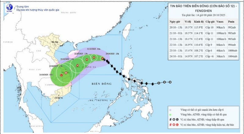 |
| Forecast map of storm No. 12's trajectory and intensity issued at 2:00 p.m. on October 20, 2025. |
In the next 72-84 hours, the tropical depression will move mainly in the southwest direction, about 10km per hour, go deep inland and gradually weaken into a low pressure area.
Sea forecast: The North East Sea area (including Hoang Sa special zone) has strong winds of level 7-8; the area near the storm's eye will have strong winds of level 9-11, gusting to level 13; waves 3-5m high, the area near the storm's eye will have waves of 5-7m high. The sea will be rough. All ships and boats operating in the above-mentioned dangerous areas are likely to be affected by storms, whirlwinds, strong winds, and large waves.
On land: Due to the influence of storm circulation and cold air combined with East wind disturbances, terrain effects and East wind after the storm, from the night of October 22-26, the area from Ha Tinh to Quang Ngai is likely to have widespread heavy rain. Forecast level of natural disaster risk due to floods: level 3.
* Weather in Vinh Long province: in the next 24 hours, the clouds will change, the day will be mostly sunny, especially in areas near the sea where the sun will be intermittent, with rain in 1/3 of the province in the afternoon and at night. Rain will be concentrated near the sea, mainly at forecast points. Coastal points will have showers and thunderstorms in the afternoon and at night. Rain will be concentrated mainly at forecast points: Long Chau, Tra Cu, Duyen Hai, Thanh Phu and Cho Lach. Light wind.
Weather in Vinh Long sea area: in the next 24 hours, the clouds will change, there will be scattered showers and thunderstorms concentrated at night, morning and noon. Northeast wind level 3-4, waves 0.5-1.5m high. The sea is normal. All vessels operating in the waters of Vinh Long province are at risk of being affected by tornadoes, strong gusts of wind and large waves during thunderstorms. Vessels operating at sea should regularly monitor and update the location and path of the storm to have direction of movement and find safe shelter.
News and photos: THAO LY
Source: https://baovinhlong.com.vn/thoi-su/202510/tu-72-84-gio-toi-ap-thap-nhiet-doi-di-sau-vao-dat-lien-va-suy-yeu-dan-9fd2617/

![[Photo] Prime Minister Pham Minh Chinh received Mr. Yamamoto Ichita, Governor of Gunma Province (Japan)](https://vphoto.vietnam.vn/thumb/1200x675/vietnam/resource/IMAGE/2025/10/21/1761032833411_dsc-8867-jpg.webp)


![[Photo] National Assembly Chairman Tran Thanh Man holds talks with Hungarian National Assembly Chairman Kover Laszlo](https://vphoto.vietnam.vn/thumb/1200x675/vietnam/resource/IMAGE/2025/10/20/1760952711347_ndo_br_bnd-1603-jpg.webp)
![[Photo] Prime Minister Pham Minh Chinh meets with Speaker of the Hungarian National Assembly Kover Laszlo](https://vphoto.vietnam.vn/thumb/1200x675/vietnam/resource/IMAGE/2025/10/20/1760970413415_dsc-8111-jpg.webp)


Comment (0)