
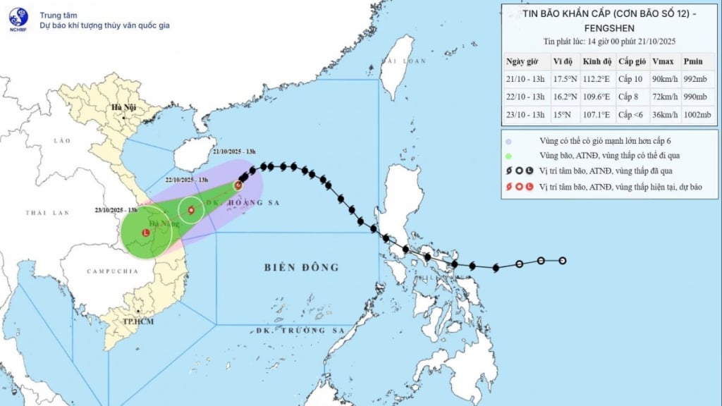
The strongest wind near the storm center is level 9-10 (75-102 km/h), gusting to level 12. The storm moves southwest at a speed of 10-15 km/h.
Forecast for the next 48 hours:
By 1 p.m. on October 22: The storm continues to move west-southwest at a speed of 10-15 km/h. The center of the storm is expected to be at about 16.2°N-109.6°E, about 145km east-northeast of Da Nang . Wind force is level 8, gusting to level 10, continuing to weaken.
Danger zone in the East Sea: from 15.0°-18.5°N; 108.5°-113.5°E.
Disaster risk level: Level 3 (Northwest sea area of the East Sea, including Hoang Sa; sea area from South Quang Tri to Quang Ngai ).
At 1:00 p.m. on October 23: The storm continued to move West Southwest, with unchanged speed, entering the mainland through the area from Quang Tri to Da Nang, then weakened into a tropical depression, then into a low pressure area over the Southern Laos area (about 15.0°N - 107.1°E).
Wind force below level 6.
Danger zone: from 14.5°-18.0°N, west of longitude 111.0°E.
Disaster risk level: Level 3 (sea area from South Quang Tri to Quang Ngai, including Con Co, Cu Lao Cham, Ly Son; coastal mainland of provinces from Quang Tri to Da Nang).
Storm impact warning:
At sea : The Northwestern sea area of the East Sea, including Hoang Sa, has strong winds of level 7-8, near the storm center level 9-10, gusting to level 12; waves 3-5m high, near the storm center 5-7m; very rough seas.
The sea area from Quang Tri to Quang Ngai (including Con Co, Cu Lao Cham, Ly Son) has strong winds of level 6, increasing to level 7 from the morning of October 22, near the storm center level 8, gusting to level 10; waves 3-5m high, rough seas.
Storm surges along the coast from Quang Tri to Da Nang could reach 0.3-0.5m.
Vessels operating in danger zones are at high risk of being affected by storms, tornadoes, strong winds and large waves.
On land : From the afternoon of October 22, coastal provinces from Quang Tri to Da Nang will have winds gradually increasing to level 6, sometimes level 7, gusting to level 8-9.
Warning of widespread heavy rain: Due to the influence of storm circulation combined with cold air and East wind, from noon on October 22 to October 27, the area from Ha Tinh to Quang Ngai will have heavy to very heavy rain, concentrated from the afternoon of October 22 to the end of October 23:
Ha Tinh - Northern Quang Tri and Quang Ngai: 200-400mm, some places over 500mm.
South Quang Tri - Da Nang: 500-700mm, some places over 900mm.
Warning: Heavy rain (>200mm in 3 hours) can cause flash floods, landslides in mountainous areas; flooding in low-lying and urban areas.
Heavy rains in the Central region are likely to last until the end of October 2025. Disaster risk level due to rain, floods and inundation: Level 3.
Localities need to proactively operate reservoirs and be ready to respond when river water levels from Quang Tri to Quang Ngai can reach or exceed alert level 3.
Thunderstorm and Tornado Risk : Throughout the storm-affected area, watch out for thunderstorms, tornadoes, and strong gusts of wind, both before and during the storm's landfall.
People and local authorities from Ha Tinh to Quang Ngai need to regularly monitor weather forecast information, take measures to prevent storms, floods and ensure safety for people and property.
Source: https://quangngaitv.vn/bao-so-12-tren-vung-bien-phia-bac-quan-dao-hoang-sa-cach-da-nang-khoang-450km-6508961.html


![[Photo] Da Nang residents "hunt for photos" of big waves at the mouth of the Han River](https://vphoto.vietnam.vn/thumb/1200x675/vietnam/resource/IMAGE/2025/10/21/1761043632309_ndo_br_11-jpg.webp)
![[Photo] Prime Minister Pham Minh Chinh meets with Speaker of the Hungarian National Assembly Kover Laszlo](https://vphoto.vietnam.vn/thumb/1200x675/vietnam/resource/IMAGE/2025/10/20/1760970413415_dsc-8111-jpg.webp)
![[Photo] Prime Minister Pham Minh Chinh received Mr. Yamamoto Ichita, Governor of Gunma Province (Japan)](https://vphoto.vietnam.vn/thumb/1200x675/vietnam/resource/IMAGE/2025/10/21/1761032833411_dsc-8867-jpg.webp)


Comment (0)