
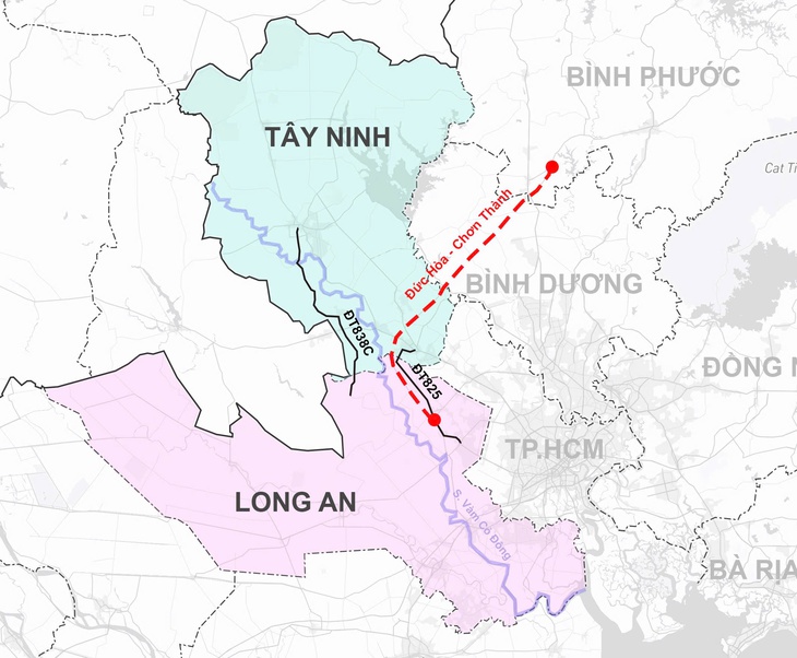
Long An and Tay Ninh with the continuous Vam Co Dong river, two routes DT838C, DT825 and Duc Hoa - Chon Thanh expressway will be the main connecting axis in the future - Graphics: PHUONG NHI
The draft submission on the resolution of the National Assembly Standing Committee on administrative unit arrangement stated: "Prioritize the arrangement of mountainous and delta units with coastal administrative units; harmoniously and reasonably combine adjacent units in line with development orientation requirements to support each other."
Tay Ninh and Long An are adjacent, Tay Ninh is located deep inland without a sea, while Long An has a sea route. And with the above criteria, according to experts' analysis, the possibility of Long An and Tay Ninh "coming together" has many foundations, complementing each other's development.
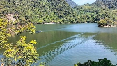
Vam Co Dong from Tay Ninh flows out to the sea
As many experts have analyzed on Tuoi Tre Online about the plan to merge the Southeast provinces, Binh Duong, Ba Ria - Vung Tau merging into Ho Chi Minh City and Binh Phuoc merging into Dong Nai are two proposals that are being discussed and highly supported.
Thus, the Southeast region only has Tay Ninh left and according to the criteria: "Prioritize the arrangement of mountainous and plain units with coastal administrative units; harmoniously and reasonably combine adjacent units...", Long An will be the choice to merge with Tay Ninh to form a new province with plains, facing the sea, adjacent to support each other.
Historically, Tay Ninh and Long An were “under the same roof” when they, along with Saigon, belonged to Phien Tran Palace during the Nguyen Lords’ time. On the map, Tay Ninh is located deep inland, Long An is adjacent to the sea, however, both share the Vam Co Dong River basin.
This river originates from Cambodia and flows into Vietnam at Chau Thanh (Tay Ninh), through the districts and towns of Ben Cau, Hoa Thanh, Go Dau, Trang Bang (Tay Ninh) with a waterway of about 98km.
Then, the Dong Vam Co River “hesitates” for about 6km between the border of the two provinces, before flowing deep into Long An province through Duc Hoa, Duc Hue, Ben Luc, Can Duoc for about 86km. And at the end of its source, it will combine with the Tay Vam Co River to form the Vam Co River to flow into the Soai Rap River and out to the East Sea.
Thus, Vam Co Dong is a continuous thread, from the source of the border to the East Sea, flowing completely through Tay Ninh and Long An with a waterway of 190km.
The unifying thread of Vam Co Dong has also entered poetry with the familiar song “You are at the head of the river, I am at the end of the river” by poet Hoai Vu, set to music by musician Phan Huynh Dieu. It includes the following passage: “You are at the head of the river, I am at the end of the river / Drinking the same water of Vam Co Dong / Loving each other for three rice seasons / Not having met again, I miss you so much / Oh, the boundless horizon of the Summer / Purple love, purple wishes”.
The “head of the river” of Vam Co Dong is Tay Ninh. And the “lower region” according to historical researcher - Dr. Nguyen Thi Hau is mainly the two districts of Can Giuoc and Can Duoc of Long An, at the end of the source of Vam Co Dong river.
How is the traffic connection between Tay Ninh and Long An?
To go from Long An to Tay Ninh, there are currently two routes. The first is provincial road 838C, separated from road 838 going from the center of Duc Hue district, passing Duong Xuong bridge connecting with provincial road 786 in Tay Ninh.
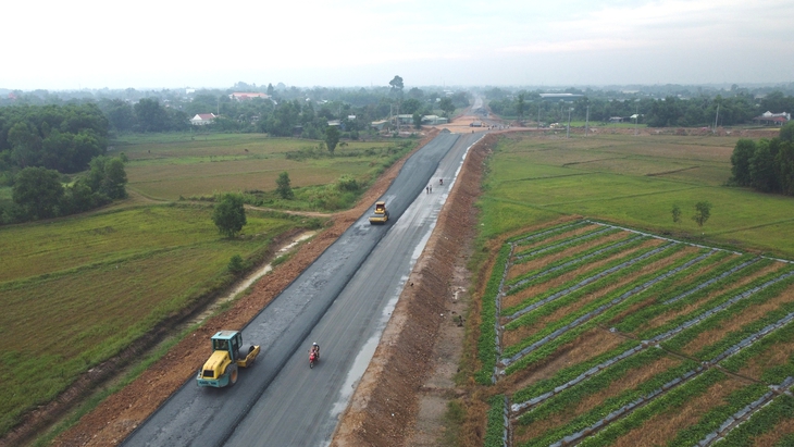
Chon Thanh - Duc Hoa Expressway is expected to open to traffic this year - Photo: SON LAM
Road 838C has been upgraded and renovated by Long An, but because this is a border area, located quite far from the main traffic routes, it currently only plays a main role in connecting the two main border gate areas of My Quy Tay (Long An) to Moc Bai international border gate (Tay Ninh).
The scale of the road when renovated is only a level IV plain road, design speed 60km/h, axle load 10 tons.
The second route is Provincial Road 825, connecting from the center of Duc Hoa district, through Loc Giang commune and connecting to Thanh Cong Industrial Park in Tay Ninh. After being renovated and upgraded from the center of Duc Hoa district to Loc Giang commune, this route has been chosen more by light truck drivers and people traveling between the two provinces.
However, the fact that both of the above routes have only recently been invested in and upgraded shows their rather "secondary" position in the traffic connecting Long An and Tay Ninh.
Most large freight vehicles and long-distance vehicles between two provinces often choose provincial road 7 or provincial road 8 to go from Duc Hoa district to national highway 22. Of course, to travel on these two routes, one must "borrow Ho Chi Minh City roads".
Expectations for Chon Thanh - Duc Hoa Expressway
A leader of the Long An Department of Construction said that the Chon Thanh - Duc Hoa expressway is nearing completion. And this will be the largest connecting route between Long An and Tay Ninh. This route is located between provincial roads 838C and 825, also known as the Western North-South expressway, and is expected to open to traffic in 2025.
The route is 72.75km long, starting at Tru Van Tho commune (Bau Bang district, Binh Duong) and ending at the intersection with National Highway N2 in Hoa Khanh Dong commune, Duc Hoa district. The total investment of the project is over VND 2,292 billion.
Long An has also proposed to soon upgrade and renovate National Highway N2 to connect with Chon Thanh - Duc Hoa Expressway to My An - Cao Lanh Expressway (Dong Thap).
When this route is available, more traffic between Long An and Tay Ninh will be diverted here, reducing the load on National Highway 22 and Provincial Roads 7 and 8, which are often under heavy traffic pressure and moving slowly.
Source: https://tuoitre.vn/uong-chung-dong-nuoc-vam-co-dong-tay-ninh-co-sap-nhap-long-an-de-noi-duong-ra-bien-20250401164711093.htm


![[Maritime News] More than 80% of global container shipping capacity is in the hands of MSC and major shipping alliances](https://vphoto.vietnam.vn/thumb/402x226/vietnam/resource/IMAGE/2025/7/16/6b4d586c984b4cbf8c5680352b9eaeb0)


Comment (0)