
Accordingly, at 7:00 a.m. this morning (September 19), storm Ragasa was active in the sea east of the Philippines, with the center of the storm at about 15.7 degrees North latitude - 131.9 degrees East longitude, about 1,000km east of Luzon Island (Philippines).
The strongest wind is level 8 (62–74 km/h), gusting to level 10. The storm is moving northwest at a speed of about 10 km/h.
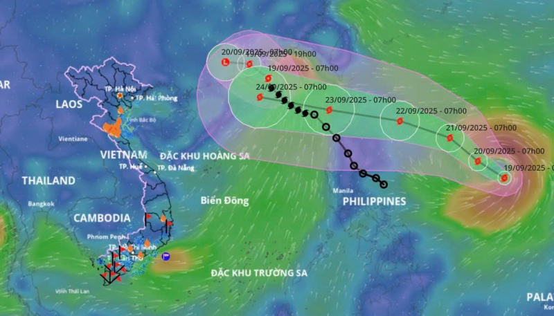
Today, Ragasa storm is moving northwest at about 10km per hour and continues to strengthen. At 7am tomorrow morning, the center of the storm will be at about 16.8 degrees North latitude - 130.1 degrees East longitude, storm intensity level 10, gust level 12.
According to the long-term forecast, in the next few days, storm Ragasa will maintain its moving direction and enter the East Sea, continue to strengthen to level 14-15, gusting above level 17 and accelerating.
From the afternoon and night of September 22, the northeastern sea area of the East Sea had strong winds of level 6-7, then increased to level 8-9. From September 23, the northern East Sea area (including Hoang Sa special zone) was directly affected by storm Ragasa with very strong intensity, level 14-16, gusting over level 17. Waves were over 10m high, the sea was rough, especially dangerous for ships operating in the northern and central East Sea.
Meanwhile, regarding storm No. 8, Mr. Nguyen Van Huong, Head of Weather Forecasting Department, National Center for Hydro-Meteorological Forecasting, said that around this afternoon to tonight (September 19), storm No. 8 will make landfall in Guangdong province (China), then move further inland, weakening into a tropical depression and then a low pressure area. Storm No. 8 is unlikely to affect the mainland of our country. However, the circulation after storm No. 8 is likely to cause widespread thunderstorms in the North from September 23 to 24.
Source: https://cand.com.vn/Xa-hoi/xuat-hien-bao-gan-bien-dong-co-kha-nang-thanh-bao-so-9-i781824/
![[Photo] Opening of the World Cultural Festival in Hanoi](https://vphoto.vietnam.vn/thumb/1200x675/vietnam/resource/IMAGE/2025/10/10/1760113426728_ndo_br_lehoi-khaimac-jpg.webp)

![[Photo] Ho Chi Minh City is brilliant with flags and flowers on the eve of the 1st Party Congress, term 2025-2030](https://vphoto.vietnam.vn/thumb/1200x675/vietnam/resource/IMAGE/2025/10/10/1760102923219_ndo_br_thiet-ke-chua-co-ten-43-png.webp)
![[Photo] Unique Phu Gia horse hat weaving craft](https://vphoto.vietnam.vn/thumb/1200x675/vietnam/resource/IMAGE/2025/10/10/1760084018320_ndo_br_01-jpg.webp)


Comment (0)