
At 4:00 a.m. on September 18, the center of the tropical depression was at about 16.7 degrees North latitude; 113.8 degrees East longitude, about 250km east of Hoang Sa; it is forecast to possibly strengthen into a storm.

According to the National Center for Hydro-Meteorological Forecasting, the tropical depression is approaching the East Sea. At 4:00 a.m. on September 18, the center of the tropical depression was at about 16.7 degrees North latitude; 113.8 degrees East longitude, about 250km east of Hoang Sa. The strongest wind near the center of the tropical depression is level 7 (50-61km/h), gusting to level 9; moving mainly west at a speed of about 25km/h. It is forecasted that in the next 24 hours, the tropical depression will likely strengthen into a storm, with intensity of level 8, gusting to level 10.
At 4:00 a.m. on September 19, the tropical depression moved in a West-Southwest direction, traveling 15-20km per hour, strengthening into a storm; the center of the storm was about 340km east-southeast of the mainland from Quang Binh to Da Nang provinces; the strongest wind near the center of the storm was level 8, gusting to level 10. Natural disaster risk level 3.
At 4:00 a.m. on September 20, the storm moved in the West Northwest direction, at a speed of about 15km/h; on the coastal areas from Quang Binh to Da Nang provinces; the strongest wind near the storm center was level 8, gusting to level 10. Natural disaster risk level 3.
In the next 48 to 72 hours, the storm will move in the West Northwest direction, traveling 10-15km per hour and weaken into a low pressure area in the Central Laos region. Due to the influence of the tropical depression, the North East Sea area (including Hoang Sa area), the sea area from Nghe An to Quang Ngai (including Ly Son island district, Cu Lao Cham, Con Co, Hon Ngu) will have strong winds of level 6-7, the area near the storm center will have level 8 (62-74km/h), gusts of level 10 (89-102km/h), waves 2-4m high, the area near the storm center will have 3-5m high, rough seas.
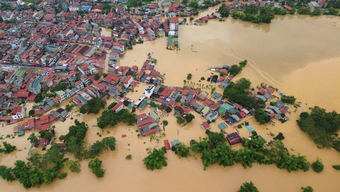
Ships operating in the above-mentioned dangerous areas are likely to be affected by storms, whirlwinds, strong winds, and large waves. On land, from early morning and on September 19, coastal mainland areas from Ha Tinh to Quang Ngai will have winds gradually increasing to level 6-7, areas near the storm's center will have winds of level 8 (62-74 km/h), gusting to level 10 (89-102 km/h); deep inland there will be gusts of level 6-7. From September 18-20, the North and Central Central regions will have heavy to very heavy rain with common rainfall from 100-300mm, locally over 500mm.
From September 18-19, the Central Highlands and the South will have moderate rain, heavy rain and thunderstorms, locally very heavy rain with common rainfall from 40-80mm, some places over 150mm; rain will concentrate in the afternoon and at night.
Experts also warned that from noon on September 18 to night on September 19, the area from Ha Tinh to Quang Ngai will have heavy rain and scattered thunderstorms, locally very heavy rain with common rainfall of 100-250mm, locally over 400mm.
From the night of September 18 to 19, Thanh Hoa and Nghe An areas will have moderate to heavy rain and scattered thunderstorms, with some places experiencing very heavy rain with common rainfall of 50-100mm, and some places experiencing over 180mm.
From September 18-19, the Central Highlands and the South will have moderate rain, heavy rain and thunderstorms, locally very heavy rain with rainfall of 30-70mm, locally over 120mm, rain concentrated in the afternoon and at night. In addition, on the evening of September 18, the Southern region of the Northern Delta will have scattered showers and thunderstorms, locally heavy rain with rainfall of 10-30mm, locally over 50mm.
On September 18, the North Central region will have rain, moderate rain and scattered thunderstorms, locally heavy to very heavy rain with rainfall from 10-30mm, locally over 80mm.
During the day and night of September 18, the South Central region will have scattered showers and thunderstorms, locally heavy rain with rainfall from 10-30mm, locally over 70mm, rain concentrated in the afternoon and evening; thunderstorms may have tornadoes, lightning and strong gusts of wind.
From the day and night of September 20, the North Central region will continue to have moderate to heavy rain, and locally very heavy rain with common rainfall of 50-100mm, and in some places over 200mm. Heavy rain in the North and Central Central regions is likely to last until around September 21. From September 20, heavy rain in the Central Highlands and the South will tend to decrease. Warning of natural disaster risk due to heavy rain, tornadoes, and lightning level 1.
Heavy rain and localized heavy rain are likely to cause flooding in low-lying areas; flash floods in small rivers and streams, and landslides on steep slopes.
Weather forecast for the day and night of September 18, the Northwest region is cloudy, with scattered showers and thunderstorms in the morning, some places with heavy rain, then showers and thunderstorms in some places; light wind; in thunderstorms there is a possibility of tornadoes, lightning and strong gusts of wind. Lowest temperature 23-26 degrees Celsius, some places below 22 degrees Celsius. Highest temperature 31-34 degrees Celsius.
The Northeast region is cloudy, with scattered showers and thunderstorms during the day, with some heavy rain in some places, followed by showers and thunderstorms in some places. North to Northwest wind level 2-3; during thunderstorms there is a possibility of tornadoes, lightning and strong gusts of wind. Lowest temperature 24-27 degrees Celsius. Highest temperature 30-33 degrees Celsius, some places above 33 degrees Celsius.
Hanoi capital is cloudy, with occasional showers and thunderstorms during the day, no rain at night. North wind level 2-3; during thunderstorms there is a possibility of tornadoes, lightning and strong gusts. Lowest temperature 25-27 degrees Celsius. Highest temperature 31-33 degrees Celsius.
Provinces from Thanh Hoa to Thua Thien-Hue are cloudy, in the North there will be rain, moderate rain and scattered thunderstorms during the day, locally heavy to very heavy rain; at night there will be moderate rain, heavy rain and thunderstorms, locally very heavy rain; in the South there will be heavy rain and thunderstorms, locally very heavy rain. North to Northwest wind level 3-4; in thunderstorms there is a possibility of tornadoes, lightning and strong gusts of wind. Lowest temperature 23-26 degrees Celsius. Highest temperature 27-30 degrees Celsius.
Provinces and cities from Da Nang to Binh Thuan, the North is cloudy with heavy rain and scattered thunderstorms, locally very heavy rain; the South is cloudy with scattered showers and thunderstorms; in the late afternoon and evening there are scattered showers and thunderstorms, locally heavy rain. West to Southwest wind level 3-4; in thunderstorms there is a possibility of tornadoes, lightning and strong gusts. Lowest temperature 24-27 degrees Celsius. Highest temperature 29-32 degrees Celsius.
The Central Highlands region is cloudy with moderate to heavy rain and scattered thunderstorms, locally very heavy rain (rain concentrated in the afternoon and night). West to Southwest wind level 3; in thunderstorms there is a possibility of tornadoes, lightning and strong gusts. Lowest temperature 20-23 degrees Celsius. Highest temperature 26-29 degrees Celsius, some places above 29 degrees Celsius.
The Southern region is cloudy with moderate to heavy rain and scattered thunderstorms, with some places experiencing very heavy rain (rain concentrated in the afternoon and at night). Southwest wind level 3; thunderstorms are likely to produce tornadoes, lightning, and strong gusts of wind. Lowest temperature 24-27 degrees Celsius. Highest temperature 28-31 degrees Celsius, some places above 31 degrees Celsius.
(Source: VNA/Vietnam+)
Source: https://baophutho.vn/ap-thap-nhiet-doi-cach-hoang-sa-khoang-250km-co-kha-nang-manh-len-thanh-bao-219260.htm
![[Photo] Opening of the World Cultural Festival in Hanoi](https://vphoto.vietnam.vn/thumb/1200x675/vietnam/resource/IMAGE/2025/10/10/1760113426728_ndo_br_lehoi-khaimac-jpg.webp)


![[Photo] Ho Chi Minh City is brilliant with flags and flowers on the eve of the 1st Party Congress, term 2025-2030](https://vphoto.vietnam.vn/thumb/1200x675/vietnam/resource/IMAGE/2025/10/10/1760102923219_ndo_br_thiet-ke-chua-co-ten-43-png.webp)
![[Photo] Unique Phu Gia horse hat weaving craft](https://vphoto.vietnam.vn/thumb/1200x675/vietnam/resource/IMAGE/2025/10/10/1760084018320_ndo_br_01-jpg.webp)


Comment (0)