
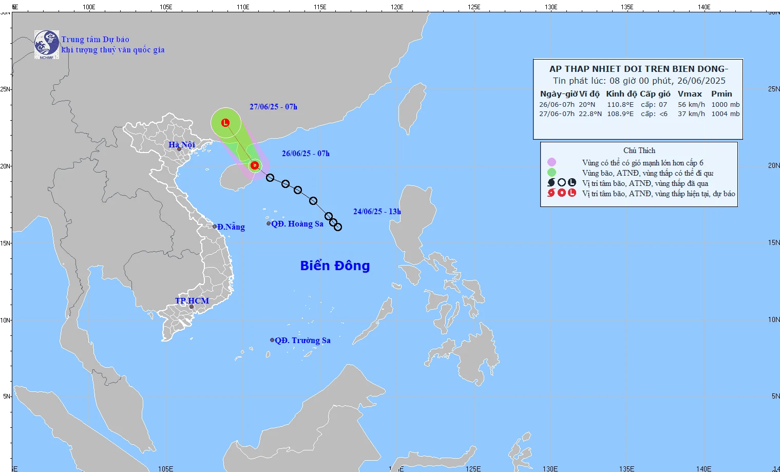
(Illustration photo: National Center for Hydro-Meteorological Forecasting)
According to the National Center for Hydro-Meteorological Forecasting, at 1:00 a.m. on July 17, the center of the tropical depression was at about 14.7 degrees North latitude; 128.5 degrees East longitude, in the sea east of the Philippines.
The strongest wind near the center of the tropical depression is level 6-7 (39 - 61 km/h), gusting to level 9; moving in the West Northwest direction at a speed of about 20 km/h.
At 1:00 a.m. on July 18, the tropical depression moved west-northwest over the sea east of Luzon Island (Philippines) at a speed of about 20 km/h and was likely to strengthen into a storm. The strongest wind of the tropical depression was level 8, gusting to level 10.
At 1:00 a.m. on July 19, the tropical depression moved northwestward over the eastern sea of the North East Sea at a speed of about 20 - 25 km/h and was likely to strengthen.
The strongest wind of the tropical depression is level 10, gusting to level 12. The affected area is the sea area east of the North East Sea. Disaster risk level 3.
From the next 48 to 72 hours, the storm will move mainly in the West Northwest direction, traveling 15-20 km per hour and is likely to strengthen.
At sea, currently in the southeastern sea of the North East Sea, the central and southern East Sea, the sea from Lam Dong to Ca Mau, from Ca Mau to An Giang and the Gulf of Thailand there are scattered showers and thunderstorms.
In Phu Quy special zone, there are southwest winds gusting at level 7, and in Huyen Tran special zone (south of Truong Sa special zone), there are winds gusting at level 10.
Forecast, day and night of July 17, in the Southeast sea area of the North East Sea and the East sea area of the central East Sea; the South East Sea area (including Truong Sa special zone), the sea area from Lam Dong to Ca Mau , from Ca Mau to An Giang and the Gulf of Thailand, there will be scattered showers and thunderstorms. During thunderstorms, there is a possibility of tornadoes, strong gusts of wind level 6-8 and waves over 2m high.
In addition, in the sea area from Lam Dong to Ho Chi Minh City, the central and southern East Sea area (including Truong Sa special zone) there are strong southwest winds of level 5, sometimes level 6, gusting to level 7.
All vessels operating in the above areas are at risk of being affected by tornadoes and strong gusts of wind.
Weather in regions day and night 7/17:
- In the Northwest, it is hot and sunny during the day, with showers and thunderstorms in some places in the late afternoon and at night. During thunderstorms, there is a possibility of tornadoes, lightning, hail and strong gusts of wind. The lowest temperature is from 24-27 degrees Celsius, in some places below 23 degrees Celsius. The highest temperature is from 33-36 degrees Celsius, in some places above 36 degrees Celsius.
- In the Northeast, it is hot and sunny during the day; in the evening and at night, there will be showers and thunderstorms in some places, with the possibility of tornadoes, lightning, hail and strong gusts of wind. The lowest temperature is 26-29 degrees Celsius. The highest temperature is 33-36 degrees Celsius, some places will be over 36 degrees Celsius.
- In Hanoi, in the late afternoon and at night, there will be showers and thunderstorms in some places, with the possibility of tornadoes, lightning, hail and strong gusts of wind; hot and sunny during the day. Light wind. Lowest temperature from 27-29 degrees Celsius. Highest temperature from 35-37 degrees Celsius, some places above 37 degrees Celsius.
- Provinces and cities from Thanh Hoa to Hue will have hot days, some places will be very hot; in the evening and at night there will be showers and thunderstorms in some places, with the possibility of tornadoes, lightning and strong gusts of wind. Southwest wind level 2-3. Lowest temperature from 26-29 degrees Celsius. Highest temperature from 34-37 degrees Celsius, some places will be over 37 degrees Celsius.
- The South Central Coast region is hot and sunny during the day, with some places experiencing severe heat; in the evening and at night, there will be showers and thunderstorms in some places, with the possibility of tornadoes, lightning and strong gusts of wind during thunderstorms. Southwest wind level 2-3. Lowest temperature from 25-28 degrees Celsius. Highest temperature from 34-37 degrees Celsius, with some places above 37 degrees Celsius.
- The Central Highlands region has scattered showers and thunderstorms, with scattered showers and thunderstorms in the afternoon and evening, with localized heavy rain. There is a possibility of tornadoes, lightning and strong gusts of wind during thunderstorms. Southwest wind level 2-3. Lowest temperature from 21-24 degrees Celsius. Highest temperature from 28-31 degrees Celsius, with some places above 32 degrees Celsius.
- The Southern region has scattered showers and thunderstorms, with scattered showers and thunderstorms in the afternoon and evening, with localized heavy rain. Thunderstorms are likely to cause tornadoes, lightning, and strong gusts of wind. Southwest wind level 2-3. Lowest temperature from 23-26 degrees Celsius. Highest temperature from 29-32 degrees Celsius, with some places above 32 degrees Celsius.
- Ho Chi Minh City has scattered showers and thunderstorms, in the afternoon and evening there will be scattered showers and thunderstorms, locally heavy rain, in thunderstorms there is a possibility of tornadoes, lightning and strong gusts of wind. Southwest wind level 2-3. Lowest temperature from 24-26 degrees Celsius. Highest temperature from 30-32 degrees Celsius.
According to VNA
Source: https://baothanhhoa.vn/ap-thap-nhiet-doi-di-chuyen-kha-nang-manh-len-thanh-bao-255054.htm


Comment (0)