
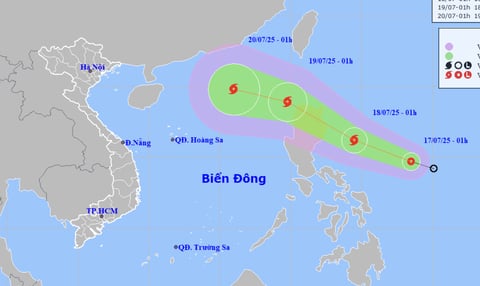
According to the National Center for Hydro-Meteorological Forecasting, at 1:00 a.m. this morning, the center of the tropical depression is in the sea east of the Philippines. The strongest wind near the center of the tropical depression is level 6-7 (39 - 61 km/h), gusting to level 9.
Forecast today and tonight (next 24 hours), the tropical depression will move rapidly in the west-northwest direction at a speed of 20km/h and is likely to strengthen into a storm. During tomorrow day and night, the storm will continue to move rapidly in the northwest direction, passing north of Luzon Island and then entering the East Sea, the storm's intensity is likely to strengthen. This will likely be the third storm in the East Sea in 2025.
At 1:00 a.m. on July 19, the storm center was in the eastern sea of the northern East Sea, the storm intensity was now level 10 (89 - 102 km/h), gusting to level 12. During the day and night of July 19, the storm moved mainly in the West Northwest direction, traveling 15-20 km per hour and still has the potential to strengthen.
The meteorological agency said that after moving into the East Sea, the storm may move west-northwest, towards the northern Gulf of Tonkin in the following days with a probability of about 50 - 60%.
Source: https://quangngaitv.vn/ap-thap-nhiet-doi-gan-bien-dong-kha-nang-thanh-bao-6504966.html


Comment (0)