
 |
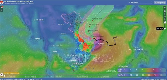
The movement of storm No. 1 seen by satellite, at 10:00 a.m. on June 12, 2025. Photo: VNA |
Commenting specifically on the developments, Dr. Hoang Phuc Lam, Deputy Director of the National Center for Hydro-Meteorological Forecasting, said that by 10:00 a.m. on June 13, the storm was moving northwestward in the southwest area of Hainan Island (China) at a speed of about 10 km/h. The storm's strongest wind was level 10, gusting to level 13. The dangerous areas were the west of the North East Sea (including the Hoang Sa area), the offshore waters from Quang Tri to Quang Ngai , and the waters of the Gulf of Tonkin. Disaster risk warning level 3.
At 10:00 a.m. on June 14, the storm moved north then changed direction to north-northeast, over the Leizhou area (China) at a speed of about 10-15 km/h. The storm's strongest wind is level 8, gusting to level 10. The dangerous area is the northwest of the North East Sea, the offshore waters from Quang Tri to Hue, and the waters of the Gulf of Tonkin. Disaster risk warning level 3.
By 10:00 a.m. on June 15, the storm was moving northeast over southern China at a speed of about 20-25 km/h. Winds were below level 6 and gradually weakened into a low pressure area.
Due to the impact of the storm, the western part of the North East Sea (including the waters of Hoang Sa archipelago), the offshore waters from Quang Tri to Quang Ngai have strong winds of level 6-8, near the eye of the storm level 9-10, gusts of level 13, waves 3-5m high, near the eye of the storm 4-6m, very rough seas. From the night of June 12, the waters of the Gulf of Tonkin have gradually increased to level 6-7, near the eye of the storm level 8-9, gusts of level 11, waves 2-4m high, very rough seas.
Ships operating in the above mentioned dangerous areas are likely to be affected by storms, whirlwinds, strong winds and large waves.
For coastal areas, due to the influence of high tides and storm surges, provinces and cities from Hai Phong to Nghe An are likely to experience abnormally high sea levels (Hon Dau 3.9m, Hon Ngu 2.8m) causing flooding in some low-lying coastal areas and river mouths between 5-7pm on June 12 and 13.
Beware of flash floods and landslides in 13 provinces
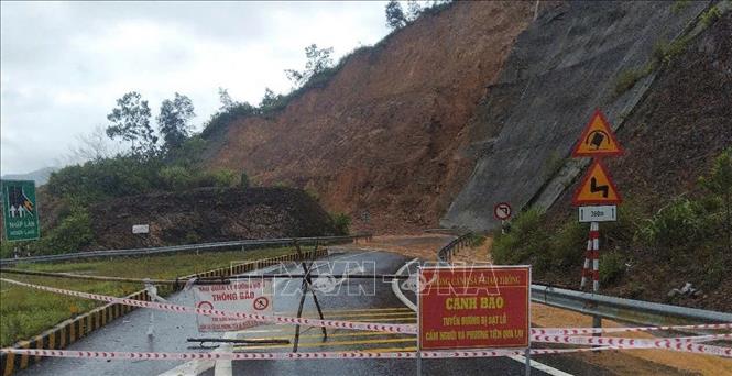 |
| Blockade and warning signs placed on a landslide-hit road section due to heavy rain in Hue. Photo: VNA |
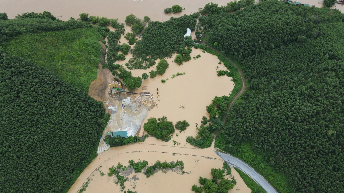
According to the National Center for Hydro-Meteorological Forecasting, from 9:40 a.m. to 2:40 p.m. on June 12, the provinces from Ha Tinh to Binh Dinh will continue to have rain with accumulated rainfall ranging from 40-90mm, in some places over 180mm; the provinces in the Central Highlands will generally have rainfall from 20-50mm, in some places over 70mm. There is a risk of flash floods on small rivers and streams, landslides on steep slopes in the above provinces, especially in the districts: Cam Xuyen, Huong Khe, Ky Anh, Ky Anh town (Ha Tinh province); Bo Trach, Le Thuy, Minh Hoa, Quang Ninh, Quang Trach, Dong Hoi city, Tuyen Hoa, Ba Don town (Quang Binh province); Cam Lo, Dakrong, Gio Linh, Hai Lang, Huong Hoa, Trieu Phong, Quang Tri town, Vinh Linh (Quang Tri province); A Luoi, Phu Loc, Phu Xuan, Huong Thuy town, Huong town
Tra, Phong Dien town (Hue city); Hoa Vang, Cam Le, Lien Chieu, Ngu Hanh Son.Son Tra (Da Nang city); Bac Tra My, Dai Loc, Dong Giang, Duy Xuyen, Hiep Duc, Nam Giang, Nam Tra My, Nui Thanh, Phu Ninh, Phuoc Son, Que Son, Tay Giang, Thang Binh, Tien Phuoc (Quang Nam province); Ba To, Binh Son, Minh Long, Mo Duc, Nghia Hanh, Son Ha, Son Tay, Son Tinh, Tra Bong, Tu Nghia, Duc Pho town (Quang Ngai province); An Lao, Hoai An, Hoai Nhon town (Binh Dinh province); Dak Glei, Dak Ha, Dak To, Ia H' Drai, Kon Plong, Kon Ray, Ngoc Hoi, Sa Thay, Kon Tum city, Tu Mo Rong (Kon Tum province); Chu Pah, Chu Prong, Ia Grai, KBang, Mang Yang (Gia Lai province); Ea H'leo, Ea Sup, Krong Buk, Krong Nang, Lak (Dak Lak province); Cu Jut, Dak Glong, Dak Mil, Dak R'Lap, Dak Song, Krong No, Gia Nghia city, Tuy Duc (Dak Nong province); Bao Lam, Dam Rong (Lam Dong province). Warning level of natural disaster risk due to flash floods, landslides, land subsidence due to heavy rain or water flow level 1, especially Hue city, Da Nang city and Quang Nam province level 2.
From 8:00 a.m. on June 11 to 8:00 a.m. on June 12, in the provinces from Ha Tinh to Binh Dinh and the Central Highlands, there was moderate to heavy rain, including: Ky Lien (Ha Tinh) 88mm; Quang Minh (Quang Binh) 157.6mm; La To Hydropower Dam (Quang Tri) 230.6mm; Bach Ma (Hue city) 641.6mm; Hoa Hai (Da Nang city) 510.4mm; Dai Hiep (Quang Ngai) 390.4mm; Dung Quat Khi Tuong (Quang Ngai) 222.8mm; Ho Can Hau (Binh Dinh) 71.6mm; Dak Ha (Kon Tum) 1 176.2mm; Cu Ne (Lam Dong) 102.2mm; Dam Rong (Lam Dong) 102.6mm;...
Soil moisture models show that some areas in the above provinces are close to saturation (over 85%) or have reached saturation.
Flash floods and landslides can have very negative impacts on the environment, threaten people's lives; cause local traffic congestion, affect the movement of vehicles; destroy civil and economic works, causing damage to production and socio-economic activities.
The Hydrometeorological Agency recommends that local authorities pay attention to reviewing bottlenecks and vulnerable locations in the area to take preventive and response measures.
Flood peaks of rivers from Quang Binh - Quang Ngai are at alert level 1 and above alert level 1.
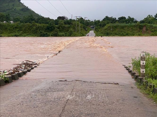 |
| Heavy rain caused the spillway in A Ngo commune to be deeply submerged in water. Photo: VNA |
The National Center for Hydro-Meteorological Forecasting said that from June 12 to June 14, there will be a flood on rivers from Quang Binh to Quang Ngai. During this flood, the peak water level on rivers will fluctuate at alert level 1 and above alert level 1; Vu Gia River (Quang Nam) will rise to alert level 1 to alert level 2. There is a high risk of flooding in low-lying areas along rivers, flash floods and landslides on steep slopes in provinces from Quang Binh to Quang Ngai (real-time warning information on areas at risk of flash floods and landslides is provided online on the website of the Department of Hydro-Meteorological Forecasting at: https://luquetsatlo.nchmf.gov.vn and in separate bulletins warning of flash floods and landslides).
Flood disaster risk level 1 warning.
Floods on rivers and streams can cause flooding in low-lying areas along rivers, affecting activities such as water transport, aquaculture, agricultural production, people's lives and socio-economic activities.
Currently, water levels on rivers in Hue and Quang Nam are rising with an amplitude of 1-3m; water levels on rivers in Quang Binh, Quang Tri, Quang Ngai are fluctuating. Water levels on rivers are still below alert level 1.
Central Central region has some places with rain over 350mm
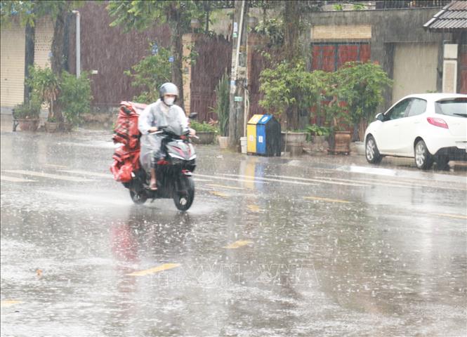 |
| People travel in heavy rain in Dong Ha city, Quang Tri province on the afternoon of June 11. Photo: Nguyen Ly/VNA |
According to the National Center for Hydro-Meteorological Forecasting, from June 12 to June 13, the Central Central region will have heavy to very heavy rain with common rainfall from 100-200mm, locally over 350mm.
During the day and night of June 12, the areas of Southern Nghe An, Ha Tinh, Northern Central Highlands and Binh Dinh will have moderate rain, heavy rain and thunderstorms, locally very heavy rain with common rainfall from 30-80mm, locally over 150mm.
Warning of risk of localized heavy rain over 200mm in 6 hours.
From the night of June 13, heavy rain in the above areas will decrease. During thunderstorms, there is a possibility of tornadoes, lightning and strong gusts of wind. The risk of natural disasters due to heavy rain is level 1.
Heavy rains are likely to cause flooding in low-lying areas, urban and industrial areas; flash floods on small rivers and streams, landslides on steep slopes (real-time warning information on areas at risk of flash floods and landslides is provided online on the website of the Department of Hydrometeorology at: https://luquetsatlo.nchmf.gov.vn and in separate bulletins warning of flash floods and landslides).
On the night of June 11 and the morning of June 12, the Central Central region will have heavy to very heavy rain and thunderstorms, the Central Highlands will have moderate rain, heavy rain and thunderstorms, and some places will have very heavy rain. The rainfall from 7:00 p.m. on June 11 to 8:00 a.m. on June 12 was over 300mm in some places, such as: Bach Ma (Hue) 551mm, Suoi Luong (Da Nang) 407.2mm, Dai Hiep (Quang Nam) 343.8mm...
Source: https://huengaynay.vn/chinh-tri-xa-hoi/bao-so-1-di-chuyen-ve-phia-tay-nam-dao-hai-nam-trung-quoc-154596.html


![[Photo] Signing of cooperation between ministries, branches and localities of Vietnam and Senegal](https://vphoto.vietnam.vn/thumb/1200x675/vietnam/resource/IMAGE/2025/7/24/6147c654b0ae4f2793188e982e272651)


Comment (0)