Storm No. 10 Bualoi enters the East Sea, heavy rain in the North
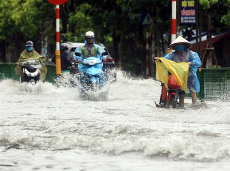
According to information from the National Center for Hydro-Meteorological Forecasting, last night and early this morning (September 26), the area from Ha Tinh to Da Nang and the Central Highlands had scattered showers and thunderstorms, locally heavy to very heavy rain with rainfall over 80mm such as: Vinh Tu station (Quang Tri) 122.2mm; Quan Tuong Dai station (Hue City) 185.6mm; Ho Thai Xuan station (Da Nang) 83.6mm...
Báo Công an Nhân dân•25/09/2025
It is forecasted that this morning until the morning of September 27, the Northeast region and Southern Phu Tho will continue to have moderate rain, heavy rain and thunderstorms, locally very heavy rain, with common rainfall of 30-70mm, locally over 150mm. Warning of the risk of heavy rain (>100mm/3 hours).
Heavy rain in the North.
In addition, the Northwest region, from Thanh Hoa to Da Nang , the Central Highlands and the South, will see rainfall of 10-30mm, with some places experiencing heavy to very heavy rain of over 80mm. During thunderstorms, there is a possibility of tornadoes, lightning, hail and strong gusts of wind.
Heavy rain can cause flooding in low-lying areas, urban and industrial areas; flash floods in small rivers and streams; and landslides on steep slopes.
Weather nationwide on Friday (September 26), Hanoi capital is cloudy, with moderate rain, heavy rain and thunderstorms, locally very heavy rain. East wind level 2-3. During thunderstorms there is a possibility of tornadoes, lightning and strong gusts of wind. Lowest temperature 23-25 degrees. Highest temperature 28-30 degrees.
The Northwest region is cloudy with scattered showers and thunderstorms, some places have heavy rain; in the South of Phu Tho, there will be moderate rain, heavy rain and thunderstorms in the evening and at night, some places have very heavy rain. Light wind. During thunderstorms, there is a possibility of tornadoes, lightning and strong gusts of wind. The lowest temperature is 22-25 degrees, some places below 21 degrees. The highest temperature is 27-30 degrees.
Northeast region is cloudy with moderate to heavy rain and scattered thunderstorms, locally very heavy rain. East wind level 2-3. During thunderstorms, there is a possibility of tornadoes, lightning and strong gusts of wind. Lowest temperature 23-26 degrees. Highest temperature 27-30 degrees, some places over 30 degrees.
From Thanh Hoa to Hue, it is cloudy with scattered showers and thunderstorms, locally heavy to very heavy rain. Light wind. During thunderstorms, there is a possibility of tornadoes, lightning, hail and strong gusts of wind. Lowest temperature 23-26 degrees. Highest temperature 27-30 degrees.
The South Central Coast is cloudy with scattered showers and thunderstorms, with some heavy rain in some places. West to southwest winds at level 2-3. During thunderstorms, there is a possibility of tornadoes, lightning, hail and strong gusts of wind. Lowest temperature 24-27 degrees. Highest temperature 30-33 degrees.
Central Highlands cloudy, scattered showers and thunderstorms, locally heavy rain (rain concentrated in the afternoon and night). Southwest wind level 2-3. During thunderstorms, there is a possibility of tornadoes, lightning, hail and strong gusts of wind. Lowest temperature 19-22 degrees. Highest temperature 25-28 degrees.
The South is cloudy with scattered showers and thunderstorms, with some places experiencing heavy rain (rain is concentrated in the afternoon and evening). Southwesterly winds level 2-3. During thunderstorms, there is a possibility of tornadoes, lightning, hail and strong gusts of wind. Lowest temperature 24-27 degrees. Highest temperature 30-33 degrees.
Ho Chi Minh City is cloudy with scattered showers and thunderstorms; in the late afternoon and evening there will be scattered showers and thunderstorms, with some heavy rain in some places. Southwest wind level 2-3. During thunderstorms there is a possibility of tornadoes, lightning, hail and strong gusts of wind. Lowest temperature 24-26 degrees. Highest temperature 31-33 degrees.
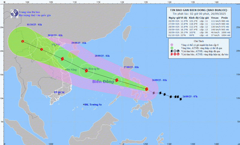
Update on Storm No. 10 (BUALOI), at 1:00 a.m. on September 26, the center of the storm was at about 11.9 degrees North latitude; 125.2 degrees East longitude, in the central region of the Philippines. The strongest wind near the center of the storm is level 11 (103-117 km/h), gusting to level 14. Moving in the West Northwest direction at a speed of 25-30 km/h. It is forecasted that around the night of September 26, storm BUALOI will enter the eastern sea area of the Central East Sea, becoming storm No. 10 in 2025.
It is forecasted that in the next 24 hours, storm No. 10 will move in the West-Northwest direction at a speed of 25-30km/h and move into the East Sea with a strong intensity of level 11, gusting to level 14.


![[Photo] Students of Binh Minh Primary School enjoy the full moon festival, receiving the joys of childhood](https://vphoto.vietnam.vn/thumb/1200x675/vietnam/resource/IMAGE/2025/10/3/8cf8abef22fe4471be400a818912cb85)
![[Photo] Prime Minister Pham Minh Chinh chairs meeting to deploy overcoming consequences of storm No. 10](https://vphoto.vietnam.vn/thumb/1200x675/vietnam/resource/IMAGE/2025/10/3/544f420dcc844463898fcbef46247d16)


![[Infographic] What are the growth targets of Dong Nai province in the first 9 months of 2025?](https://vphoto.vietnam.vn/thumb/402x226/vietnam/resource/IMAGE/2025/10/3/45f9330556eb4c6a88b098a6624d7e5b)


Comment (0)