
Strongest wind: Level 9 (75-88 km/h), gust level 11.
Due to the impact of storm No. 3, in Bach Long Vi special zone, there were strong winds of level 10, gusting to level 12; Co To special zone had strong winds of level 8, gusting to level 11; Cat Ba (Cat Hai special zone) had strong winds of level 6, gusting to level 8; Cua Ong had strong winds of level 9, gusting to level 12; Bai Chay had strong winds of level 8, gusting to level 9; Quang Ha had strong winds of level 8; Tien Yen had strong winds of level 7, gusting to level 9; Thai Binh station had strong winds of level 7, gusting to level 8; Mong Cai had strong winds of level 6, gusting to level 9; Phu Lien had strong winds of level 6, gusting to level 8... In the plains and coastal areas of the North, Thanh Hoa, Nghe An had moderate rain, heavy rain, some places had very heavy rain with common rainfall of 50-100mm, some places over 130mm.
Forecast in the next 3 hours, the storm moves in the West Southwest direction, speed about 15km/hour.
Storm forecast (in the next 12 to 48 hours):
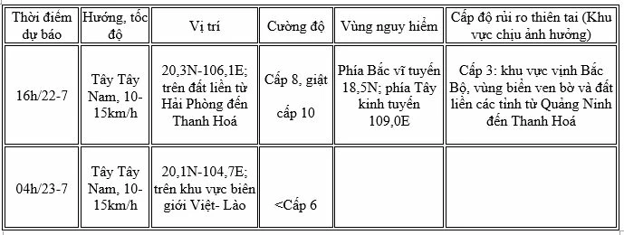 |
The coastal areas of Hung Yen - Quang Ninh have storm surges of 0.5-1.0m high. Water levels in Ba Lat (Hung Yen) are 2.4-2.6m high, Hon Dau ( Hai Phong ) are 3.9-4.1m high, in Cua Ong (Quang Ninh) are 4.6-5.0m high and in Tra Co (Quang Ninh) are 3.6-4.0m high. There is a high risk of flooding in coastal areas and river mouths at noon and afternoon on July 22.
Warning: Coastal mainland areas during storms are extremely dangerous and unsafe for any vehicles or structures operating in dangerous areas such as: cruise ships, passenger ships, cargo ships, cages, rafts, aquaculture areas, dykes, embankments, coastal routes. Vehicles are at high risk of capsizing, destruction, and flooding due to strong winds, storms, whirlwinds, large waves, and rising sea levels.
On the mainland, coastal areas from Quang Ninh to Nghe An have strong winds of level 7-8, near the storm center level 9-10, gusting to level 13; inland areas of the provinces/cities of Hai Phong, Hung Yen, Bac Ninh, Hanoi, Ninh Binh and Thanh Hoa have strong winds of level 6, gusting to level 7-8. Winds of level 9-10 can break trees, electric poles, and blow off roofs, causing very heavy damage.
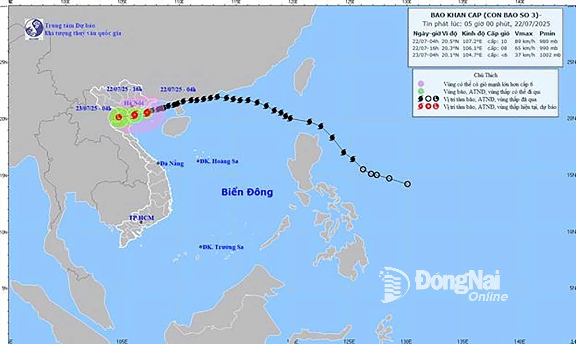 |
| Map of forecast trajectory and intensity of storm No. 3, released at 5:00 a.m., July 22. |
Storm No. 3 does not directly affect the weather in Dong Nai province. The weather in the province is cloudy to cloudy, with intermittent sunshine during the day, with scattered showers and thunderstorms in the afternoon and evening, with moderate to heavy rain in some places. During thunderstorms, be on guard against thunder, strong gusts of wind and tornadoes.
Kim Lieu
Source: https://baodongnai.com.vn/xa-hoi/202507/bao-so-3-khong-anh-huong-truc-tiep-den-thoi-tiet-khu-vuc-tinh-dong-nai-3e9007f/


Comment (0)