
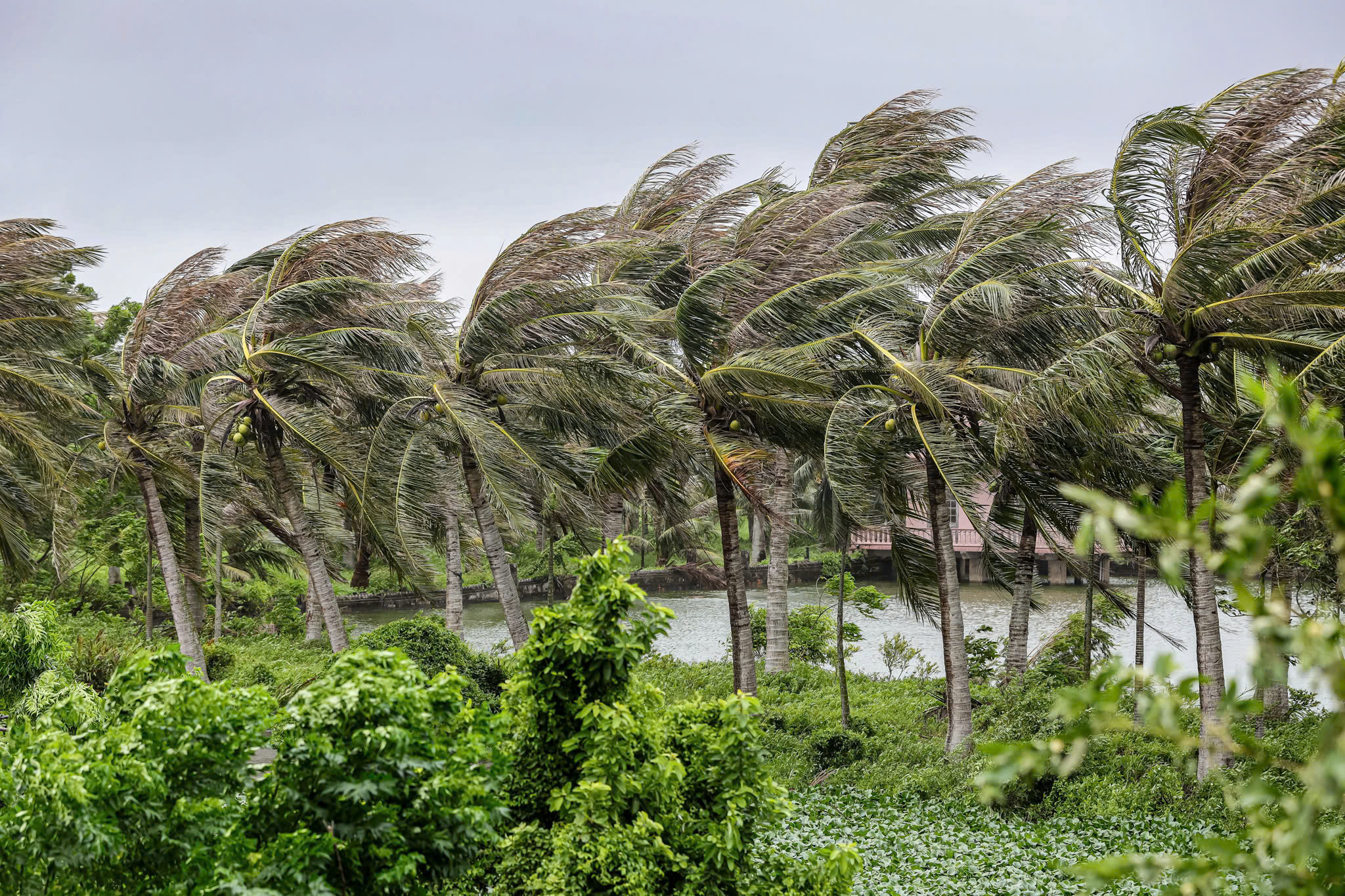
At noon on July 22, strong storm winds blew along the coast of Giao Phuc commune (Ninh Binh, formerly part of Nam Dinh province) - Photo: DANH KHANG
According to the National Center for Hydro-Meteorological Forecasting at 1:00 p.m. on July 22, the center of storm No. 3 was on land in Ninh Binh - Thanh Hoa, the strongest wind near the center of the storm was level 8 (62-74 km/h), gusting to level 10.
Nghe An , Thanh Hoa still have heavy rain
Forecast on the afternoon of July 22, storm No. 3 (Wipha) continues to move west-southwest and weakens into a tropical depression. Then it continues to weaken into a low pressure area over upper Laos.
The meteorological agency forecasts that in the afternoon of July 22, the Bac Bo Gulf area (including the special zones of Bach Long Vi, Co To, Van Don, Cat Hai, Hon Dau and Hon Ngu islands) will have strong winds of level 6-7, near the storm center of level 8, gusting to level 10, waves 2-4m high, rough seas.
In the coastal area of Ninh Binh - Quang Ninh, the storm surge is 0.4-0.8m high. The coastal water level continues to rise this afternoon following the tide and storm surge. In Ba Lat (Hung Yen), the water level is 2.8-3.1m high, in Hon Dau (Hai Phong), it is 3.9-4.2m high, and in Cua Ong (Quang Ninh), it is 4.4-4.8m high. There is a high risk of flooding in coastal areas and river mouths.
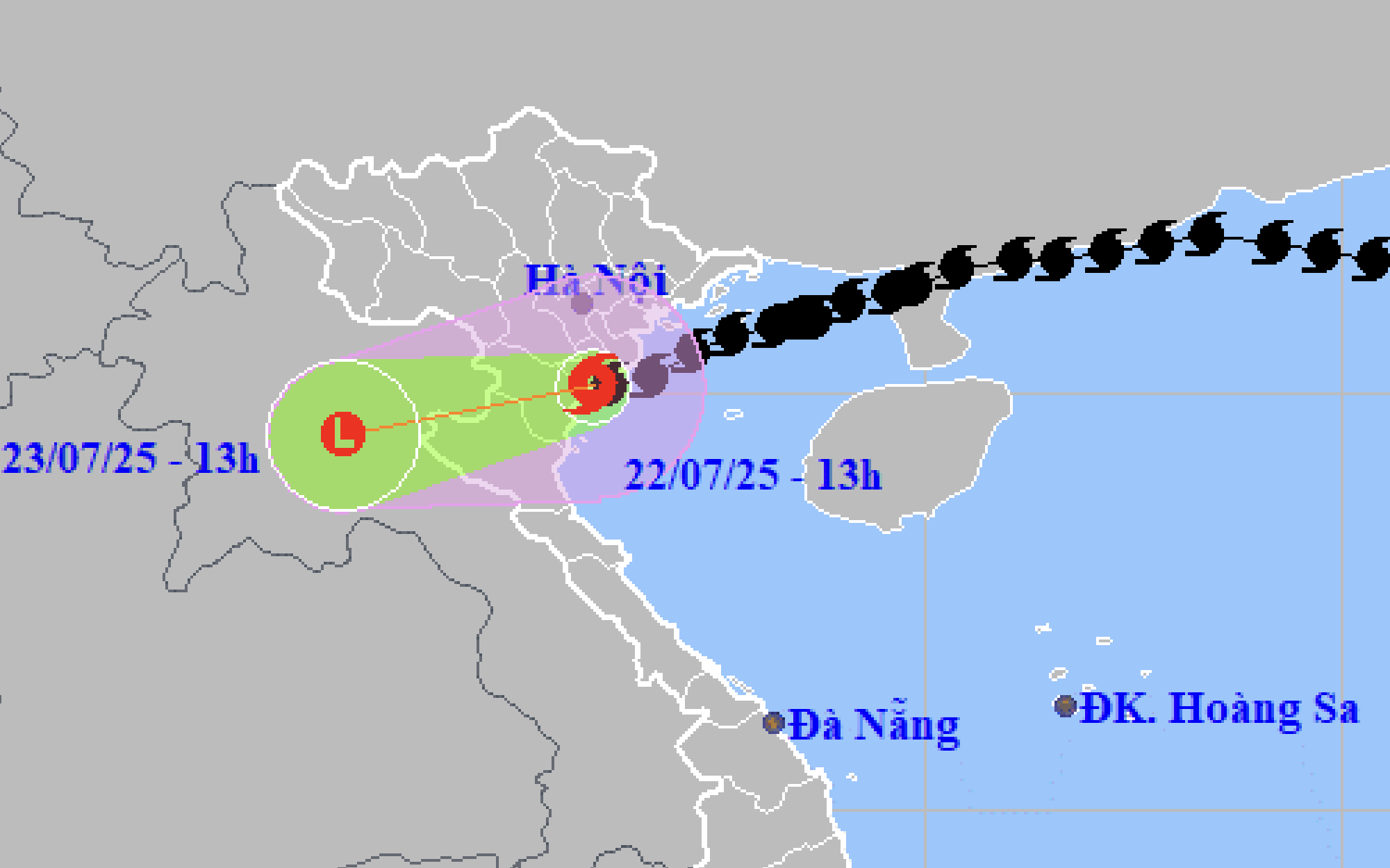
Forecast of location and direction of storm No. 3 at 1:00 p.m. this afternoon - Photo: NCHMF
Coastal areas from Quang Ninh to Nghe An have strong winds of level 6-7, near the storm center level 8, gusting to level 10. Inland areas of the provinces and cities of Hai Phong, Hung Yen, Bac Ninh, Hanoi, Ninh Binh and Thanh Hoa have gusts of level 6-8.
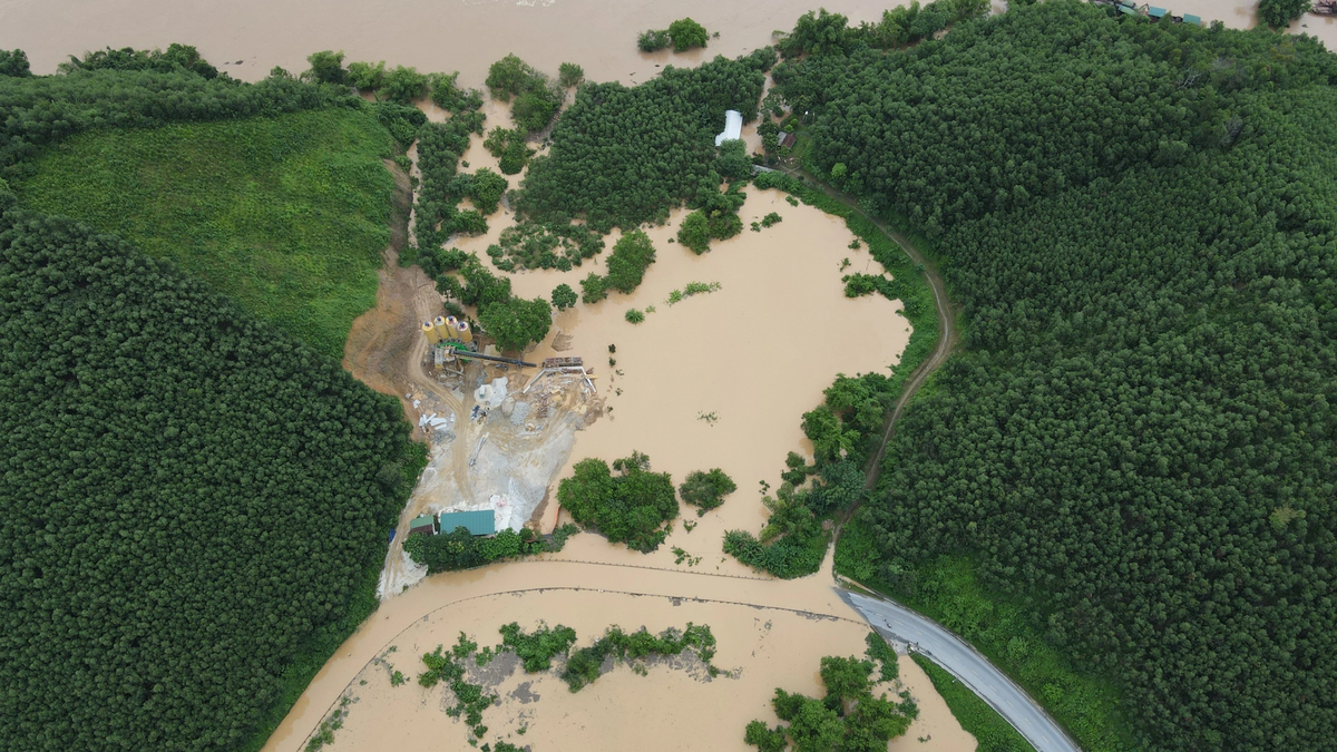
From this afternoon to the morning of July 23, Thanh Hoa, Nghe An, southern Phu Tho and Son La will have heavy to very heavy rain and thunderstorms. Rainfall is generally 60-120mm, locally over 200mm.
Other places in the Northern region and Ha Tinh have rain, moderate rain, locally heavy rain and thunderstorms with rainfall of 20-40mm, locally over 100mm.
Beware of heavy rain over 150mm in 3 hours causing flash floods, landslides in mountainous areas, and flooding in low-lying areas.
Co To Island: record high tide, water level rises more than 4m
At 2:20 p.m., Ms. Le Ngoc Han, Party Secretary of Co To Special Zone (Quang Ninh Province), said that the circulation after storm No. 3 caused a record high tide. The water level was about 4.2 meters in the sea area in front of the Uncle Ho monument square.
"This is something that has never happened in this area. Locals call this the "Southern wave" phenomenon, where the South wave meets the South wind. The high tide starts at 12:30 p.m., and the water rises to create the highest waves at around 2 p.m.," said Ms. Han.
Currently, there is no rain on the island, but there are still strong winds, with waves hitting the embankment at times as high as 2-3 meters. The authorities of the Co To Special Zone are constantly patrolling the coastal road, deploying plans to ensure the safety of the people.
"According to local people's experience, the water will recede after 1 hour. The phenomenon of high tide is an unusual development that risks affecting the sea dike in this area.
Faced with the above developments, Co To special economic zone has taken immediate action to assess the impact and propose solutions to ensure safety," Ms. Han informed.
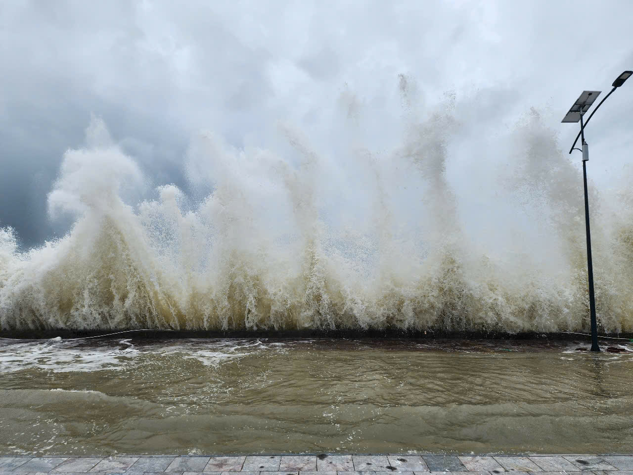
Rising water combined with high tides caused sea levels to rise more than 4m in Co To - Photo: THU BAU
Water level in Hung Yen coastal estuary rises, surpassing historical record
According to the National Center for Hydro-Meteorological Forecasting, due to the impact of storm No. 3, sea levels are rising, and in addition, the coastal area of Hung Yen province is experiencing strong southeast winds, pushing water from the sea to the shore.
At coastal stations and coastal estuaries, water levels have risen from 0.5-0.8m.
At Ba Lat hydrological station (Hung Yen, former Thai Binh province), the water level rose 0.8m, the highest water level at 2:50 p.m. reached 2.97m - exceeding the 2017 historical level by about 0.26m.
At Dong Quy hydrological station (Hung Yen, former Thai Binh province), the water level rose 0.6m, the water level was 2.44m and continued to rise.
Storm No. 3 caused waves 3.5m high at Bach Long Vi at 7pm on July 21, and 2.5m at Co To (Quang Ninh) at 7am on July 22. Storm surge at 10am on July 22 at Hon Dau (Hai Phong) was 0.6m and at Ba Lat (Hung Yen) was 0.8m.
According to the National Center for Hydro-Meteorological Forecasting, due to the impact of storm No. 3, in Bach Long Vi special zone (Hai Phong) and Cua Ong (Quang Ninh), there were strong winds of level 10, gusting to level 12; Tien Yen (Quang Ninh) strong winds of level 10, gusting to level 14; Co To and Quang Ha special zone (Quang Ninh) strong winds of level 9, gusting to level 11; Bai Chay (Quang Ninh) strong winds of level 8, gusting to level 10;
Ba Lat (Hung Yen) has strong winds of level 8, gusts of level 9; Thai Binh (Hung Yen) has strong winds of level 7, gusts of level 8;
Hon Dau (Hai Phong) has strong winds of level 9; Phu Lien (Hai Phong) has strong winds of level 6, gusts of level 8; Cat Ba (Hai Phong) has strong winds of level 6, gusts of level 8...
In Thanh Hoa and Nghe An, there is heavy to very heavy rain with common rainfall of 100-200mm, some places over 300mm. Storm surge at Hon Dau (Hai Phong) is 0.6m high and at Ba Lat (Hung Yen) is 0.8m high.
Tuoitre.vn
Source: https://tuoitre.vn/bao-so-3-tren-dat-lien-ninh-binh-thanh-hoa-nuoc-bien-o-co-to-dang-hon-4m-20250722143844862.htm


![[Photo] Signing of cooperation between ministries, branches and localities of Vietnam and Senegal](https://vphoto.vietnam.vn/thumb/1200x675/vietnam/resource/IMAGE/2025/7/24/6147c654b0ae4f2793188e982e272651)


Comment (0)