
The National Center for Hydro-Meteorological Forecasting said the tropical depression's wind force is level 7, gusting to level 9 in the Ninh Binh - Thanh Hoa area.
Explaining why the storm reached the shore at level 8-9, not strong but lasting for up to 9 hours, Mr. Nguyen Van Huong, Head of Weather Forecasting Department (National Center for Hydro-Meteorological Forecasting) said that because the storm was located on the tropical convergence zone, it was energized and motivated to maintain its intensity.
At the same time, when the storm first enters the East Sea, the subtropical high pressure tongue determines the direction and speed of the storm's movement, causing the storm to move quickly. When entering the Gulf of Tonkin, the subtropical high pressure tongue weakens, causing the storm to slow down.
At the same time, when the storm first enters the East Sea, the subtropical high pressure tongue encroaches, causing the storm to move quickly. However, when the storm enters the Gulf of Tonkin, the subtropical high pressure tongue weakens, causing the storm to slow down.
"From this afternoon until now, the storm has been moving very slowly. Because it is moving slowly and has not penetrated far into the mainland, the storm's intensity has been maintained longer, and the wind in coastal areas has also lasted longer," Mr. Huong added.
Storm No. 3 caused strong winds in the coastal areas of the North and North Central regions from 1:00 p.m. yesterday to noon today. The strongest winds on land were recorded at Tien Yen station ( Quang Ninh ) at level 10, gusting to level 14. Coastal stations such as Cua Ong ( Quang Ninh ) at level 10, gusting to level 12; Quang Ha ( Quang Ninh ) at level 9, gusting to level 11; Bai Chay ( Quang Ninh ) at level 8, gusting to level 10.
Stations such as Mong Cai (Quang Ninh) wind level 7, gust level 9; Thai Binh level 7, gust level 8; Ba Lat (Hung Yen) level 8, gust level 9; Hon Dau (Hai Phong) level 8, gust level 9; Phu Lien (Hai Phong) level 6, gust level 8.
From 7am yesterday to 1pm today, the storm caused 100-200mm of rain, many places over 300mm in the North, Thanh Hoa, Nghe An. The heaviest rain was recorded in Nga Son (Thanh Hoa) 412mm, Sam Son 379mm, Trieu Son 336mm, Nhu Thanh 327mm. Hai Anh, Giao Linh, Tam Diep stations (Ninh Binh) had over 260mm of rain.

Storm No. 3 caused waves 3.5 m high at Bach Long Vi at 7 pm yesterday, and 2.5 m high at Co To at 7 am today. Storm surge at 10 am at Hon Dau (Hai Phong) was 0.6 m and at Ba Lat (Hung Yen) was 0.8 m.
Although the storm has weakened, the circulation and tropical convergence zone will still cause rain in many provinces and cities. In particular, Lao Cai, Son La, Ha Tinh provinces will have 20-40 mm of rain, some places will have over 70 mm; Thanh Hoa, Nghe An and southern Phu Tho will have heavier rain of 40-60 mm, some places will have over 180 mm. There is a high risk of flash floods and landslides in the above areas, especially the mountainous areas of Thanh Hoa and Nghe An.
Since the beginning of the year, the East Sea has seen three storms, two of which have affected Vietnam. The meteorological agency predicts that from now until October, the East Sea will see about seven storms, three of which will affect the mainland.
The Department of Dyke Management and Natural Disaster Prevention said that by 5 p.m., authorities had evacuated nearly 11,800 people due to the storm, with the highest number in Hai Phong with nearly 5,000 people and Ninh Binh with more than 4,700 people. About 730 others in Thanh Hoa and Nghe An had to be evacuated due to flooding and landslides.
Initial statistics show that 79 houses in Nghe An had their roofs blown off, and more than 107,000 hectares of rice were flooded, mainly in Ninh Binh with more than 74,000 hectares. Some dike incidents occurred in Da Phuc (Hanoi); Nghia Son (Ninh Binh) and Hoang Chau (Thanh Hoa).
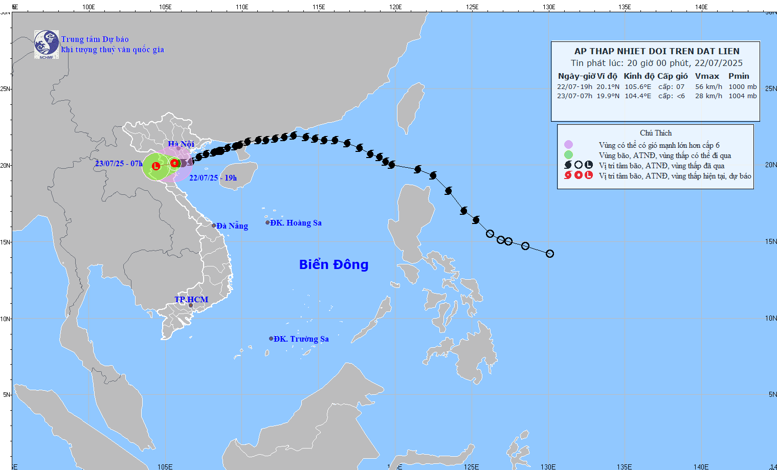
At 7:00 a.m. on July 23 , the tropical depression continued to move in the West Southwest direction, at a speed of about 10 km/h and gradually weakened into a low pressure area.
Forecast location is approximately 19.9°N – 104.4°E, over Upper Laos.
Dangerous area at sea: North of latitude 18.5°N; West of longitude 107.5°E.
On the night of July 22, the sea area west of the Gulf of Tonkin (including the special zones of Bach Long Vi, Co To, Van Don, Cat Hai, Hon Dau and Hon Ngu islands): Strong winds level 6-7, gusting to level 8-9; waves 2.0-4.0m high; rough seas.
Source: https://baohaiphongplus.vn/bao-so-3-suy-yeu-thanh-ap-thap-nhiet-doi-tiep-tuc-gay-mua-to-cho-thanh-hoa-nghe-an-417007.html


![[Infographic] Vietnam-Senegal traditional friendship](https://vphoto.vietnam.vn/thumb/1200x675/vietnam/resource/IMAGE/2025/7/23/4c96a604979345adb452af1d439d457b)


Comment (0)