

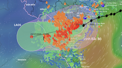
Latest developments of storm No. 3 - Photo: National Center for Hydro-Meteorological Forecasting
At 1:00 p.m. on July 22, the center of the storm was at about 20.1 degrees North latitude; 106.0 degrees East longitude, on the mainland of Ninh Binh - Thanh Hoa provinces. The strongest wind near the center of the storm was level 8 (62-74 km/h), gusting to level 10; moving west at a speed of 10-15 km/h. West Southwest, 10-15 km/h and weakening into a tropical depression before continuing to weaken into a low pressure area.
On the afternoon of July 22, the Bac Bo Gulf area (including the special zones of Bach Long Vi, Co To, Van Don, Cat Hai, Hon Dau and Hon Ngu islands) had strong winds of level 6-7, near the storm center of level 8, gusting to level 10; waves 2.0-4.0m high; rough seas.
Storm surge and coastal flooding warning: Coastal areas of Ninh Binh- Quang Ninh have storm surges of 0.4-0.8m high.
Coastal water levels continue to rise this afternoon following the tide and storm surge. In Ba Lat (Hung Yen), the water level is 2.8-3.1m, in Hon Dau ( Hai Phong ), it is 3.9-4.2m and in Cua Ong (Quang Ninh), it is 4.4-4.8m. There is a high risk of flooding in coastal areas and river mouths.
According to the National Center for Hydro-Meteorological Forecasting, in the next 24 hours, storm No. 3 will move in the West-Southwest direction, at a speed of 10-15km/h and weaken into a tropical depression, then continue to weaken into a low pressure area.
From July 22 to July 23, in the southern region of the Northern Delta, Thanh Hoa and Nghe An, there will be heavy to very heavy rain and thunderstorms with common rainfall of 100-200mm, locally over 300mm; other places in the Northern region and Ha Tinh will have moderate rain, locally heavy rain and thunderstorms with rainfall of 20-50mm, locally over 100mm.
Warning of risk of heavy rain (>150mm/3h). Heavy rain in a short period of time can cause flash floods, landslides in mountainous areas, and flooding in low-lying areas.
Causes of different weather in storm circulation number 3
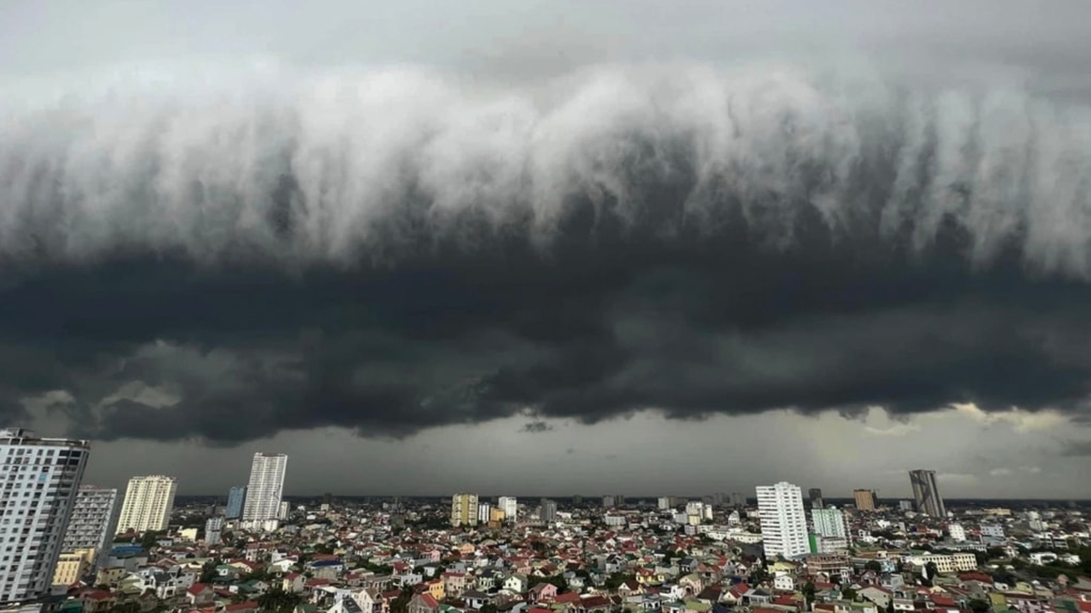
On the morning of July 22, although all areas were affected by storm No. 3, the weather in different areas was clearly different: Some places had heavy rain and strong winds, while others were sunny.
Mr. Hoang Phuc Lam, Deputy Director of the National Center for Hydro-Meteorological Forecasting (Department of Hydro-Meteorology, Ministry of Agriculture and Environment) explained: Not all clouds in the storm circulation cause rain. In the storm cloud system, there are many layers of clouds, in which high-level clouds sometimes only block the sun. Therefore, there are areas that are covered by clouds but still have no rain or sometimes the rain is intermittent and then stops.
In the coastal areas where the storm made landfall, Hung Yen and Ninh Binh, before the storm hit, the sky was sunny for a while, then there were strong winds, heavy rain, and waves several meters high.
Mr. Hoang Phuc Lam said: Storm No. 3 has the characteristic of thunderstorms causing rain concentrated in the South, so when the storm center has moved inland, the storm circulation still causes heavy to very heavy rain, especially in the southern provinces such as Thanh Hoa and Nghe An. The common rainfall here during the day and tonight can reach 150-300mm, or even higher.
Meanwhile, in localities located in the northern part of the storm circulation such as Hanoi and the Northeast region, the rain has gradually decreased compared to the day and night of July 21. Note that the rain continues but is intermittent: Sometimes it rains lightly, sometimes it stops, and in some places it does not rain for many hours.
To know if there is a thunderstorm in their area, Mr. Hoang Phuc Lam recommends that people follow the weather radar map on the website https://iweather.gov.vn/. On the radar, areas with strong thunderstorms, heavy rain and lightning will appear orange or red. Gray-black areas have almost no radar response, indicating that the sky is sunny or just cloudy. Blue and light blue areas are light rain and moderate rain.
In particular, the current weather radar system updates new data every 10 minutes, allowing people to monitor in almost real time. In addition to rain radar, satellite data also shows the location and density of lightning within the past hour - a very important factor in identifying areas at risk of strong thunderstorms, heavy rain with dangers such as tornadoes or lightning strikes.
Thu Cuc
Source: https://baochinhphu.vn/bao-so-3-suy-yeu-thanh-ap-thap-nhiet-doi-trong-24h-toi-10225072215043835.htm


Comment (0)