
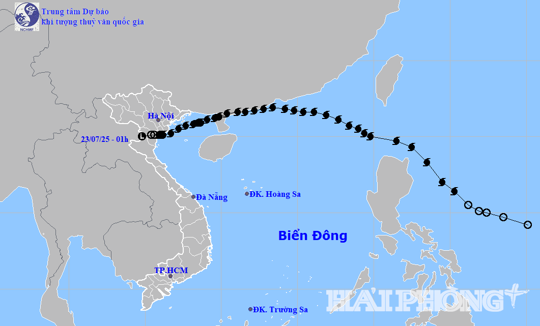
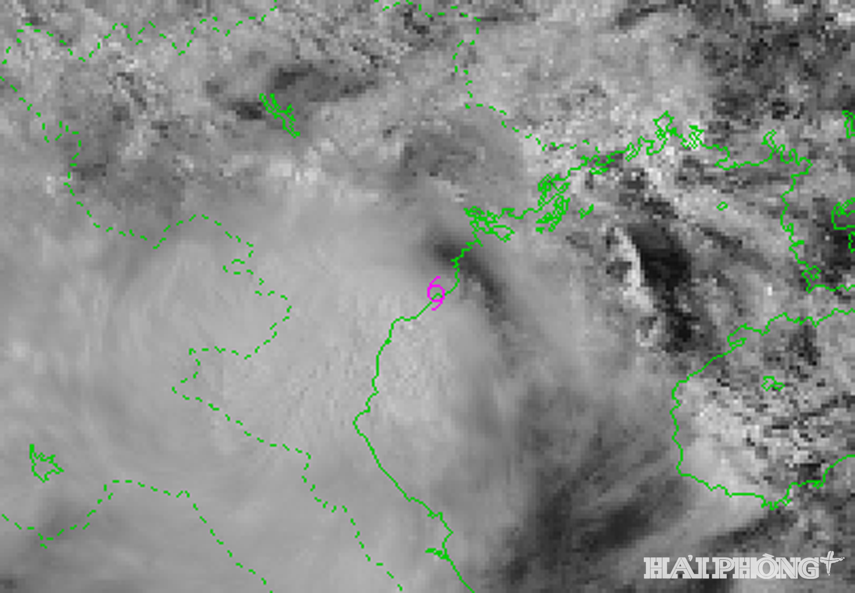
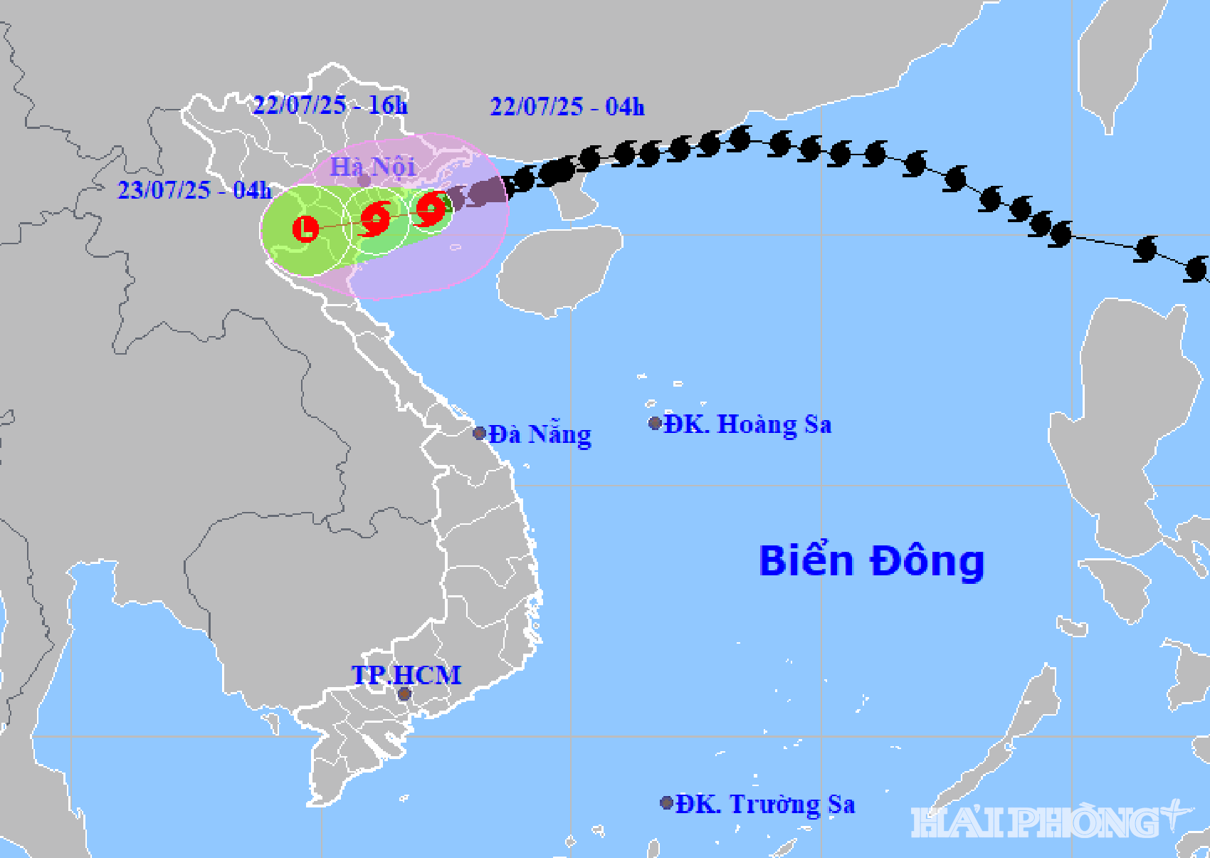
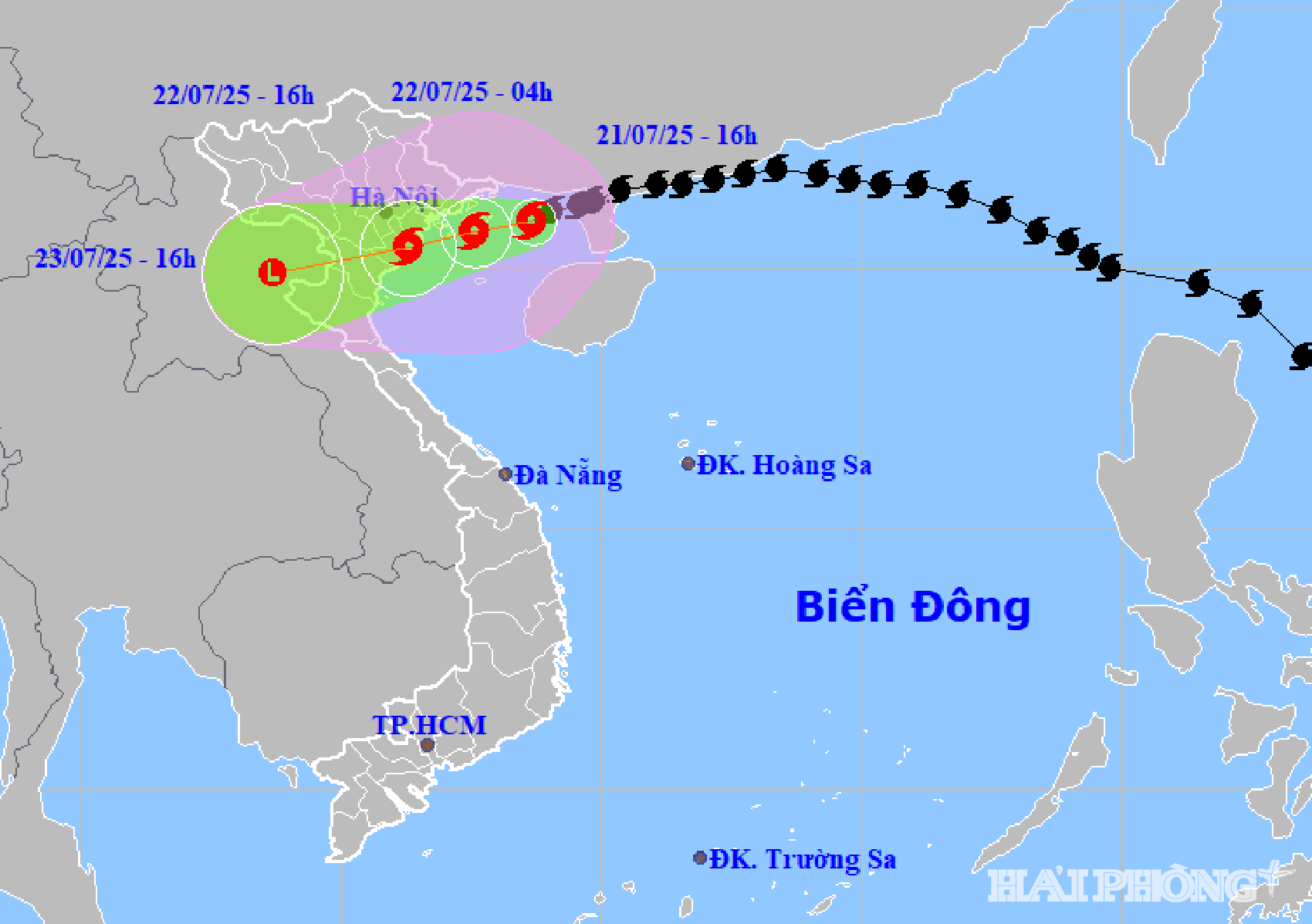
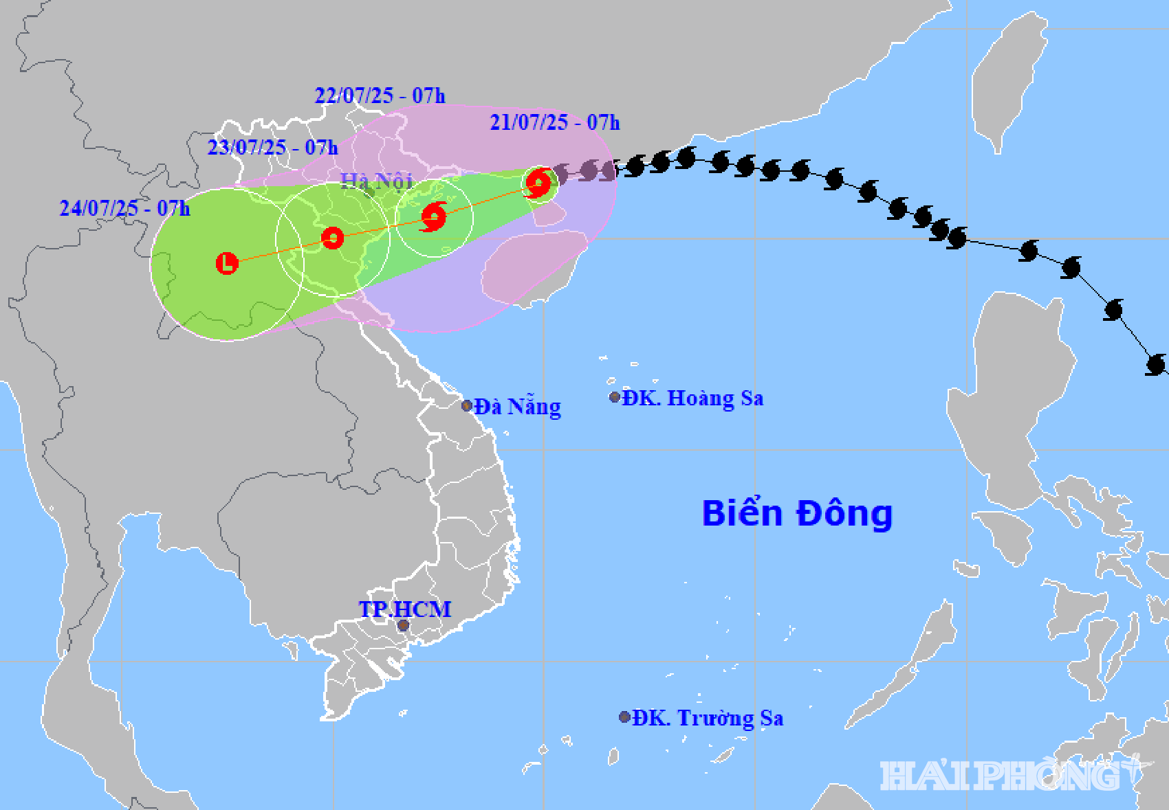
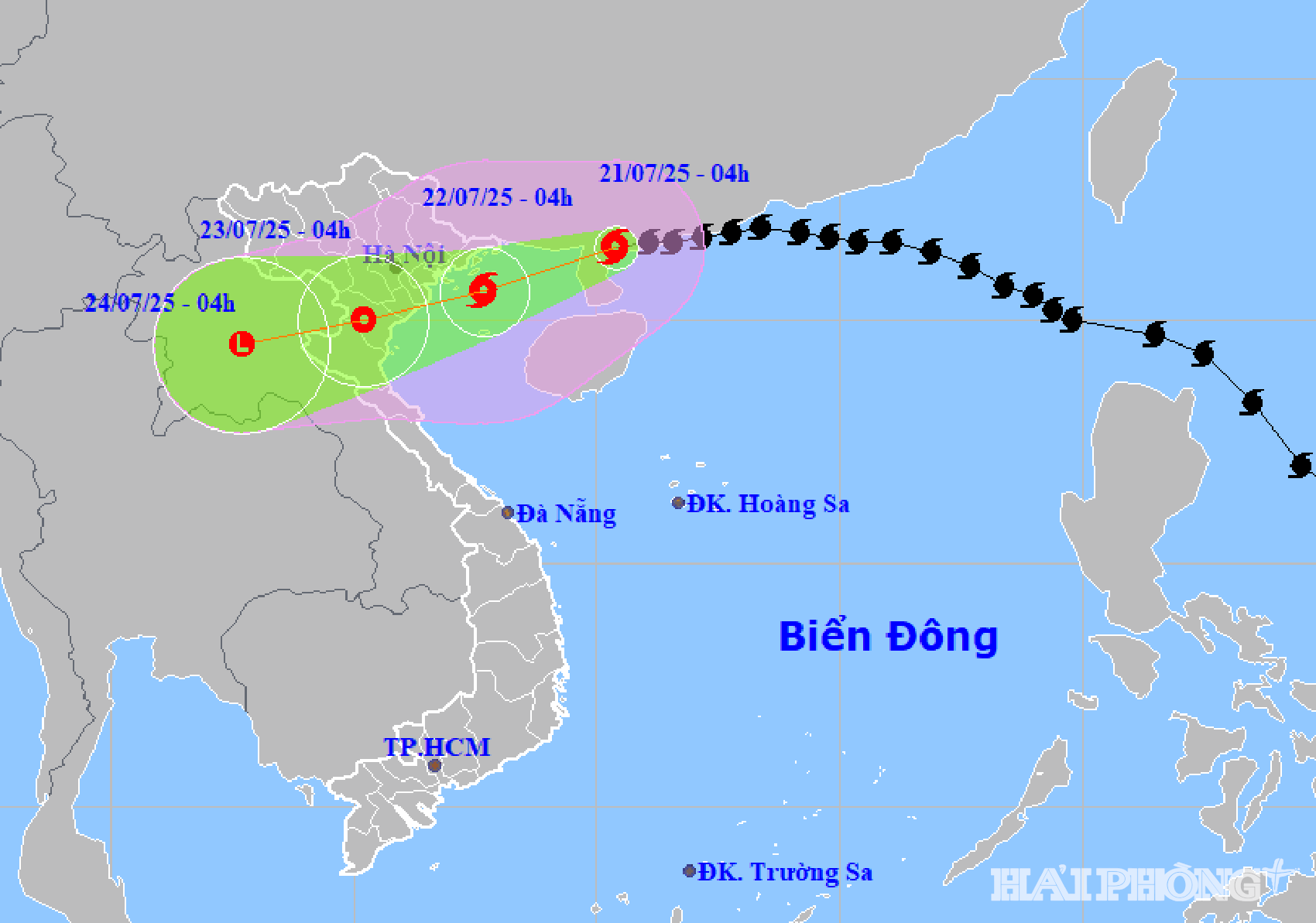
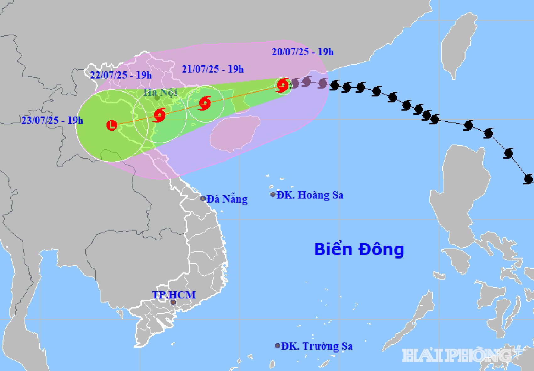
At 1:00 a.m. on July 23, the low pressure area was located at about 20 degrees North latitude; 104.8 degrees East longitude. The strongest wind in the center of the low pressure area was below level 6 (below 39 km/h).
Forecast in the next 12 hours, the low pressure area will continue to move mainly in the West Southwest direction, weakening and gradually dissipating. This is the last news about storm number 3.
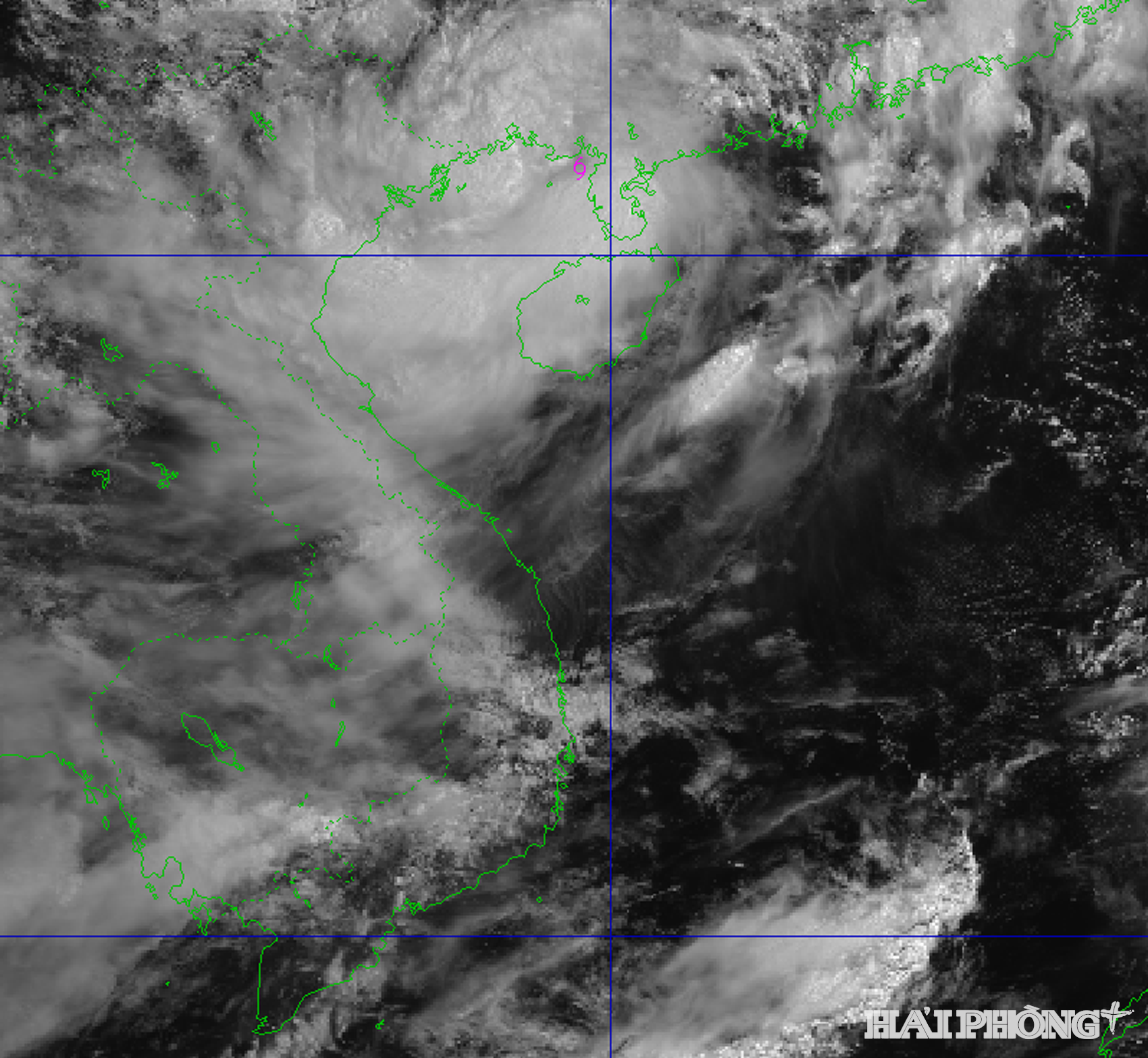
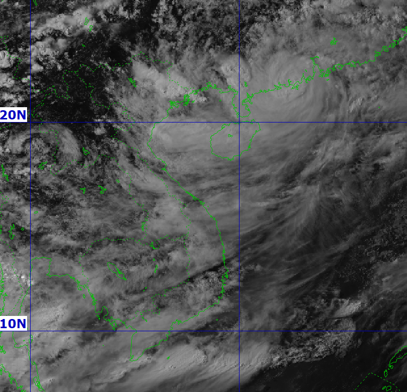
Previously, from the evening of July 22, when it made landfall in the provinces from Hung Yen to Ninh Binh, storm No. 3 (storm WIPHA) moved very little, causing strong winds and heavy rain on land.
Explaining why storm No. 3 made landfall at level 8-9, not strong but lasting for up to 9 hours, Mr. Nguyen Van Huong, Head of Weather Forecast Department (National Center for Hydro-Meteorological Forecasting) said that because the storm is located on the tropical convergence zone, it is energized and motivated to maintain its intensity.
Along with that, when the storm first enters the East Sea, the subtropical high pressure tongue determines the direction and speed of the storm's movement, causing the storm to move quickly. When entering the Gulf of Tonkin, the subtropical high pressure tongue weakens, slowing down the storm, so the storm's intensity is retained longer, and the wind in the coastal area is therefore also longer.
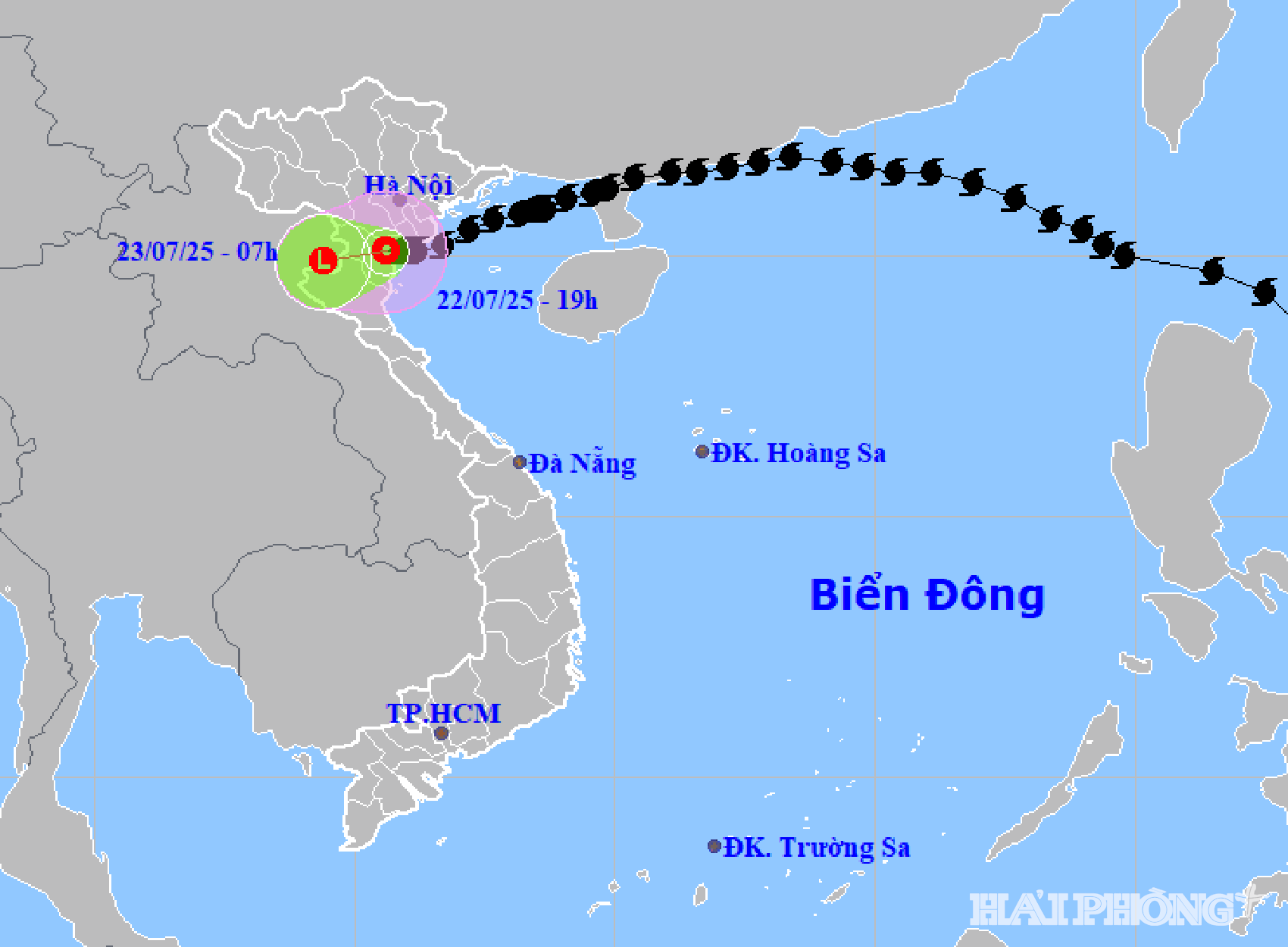
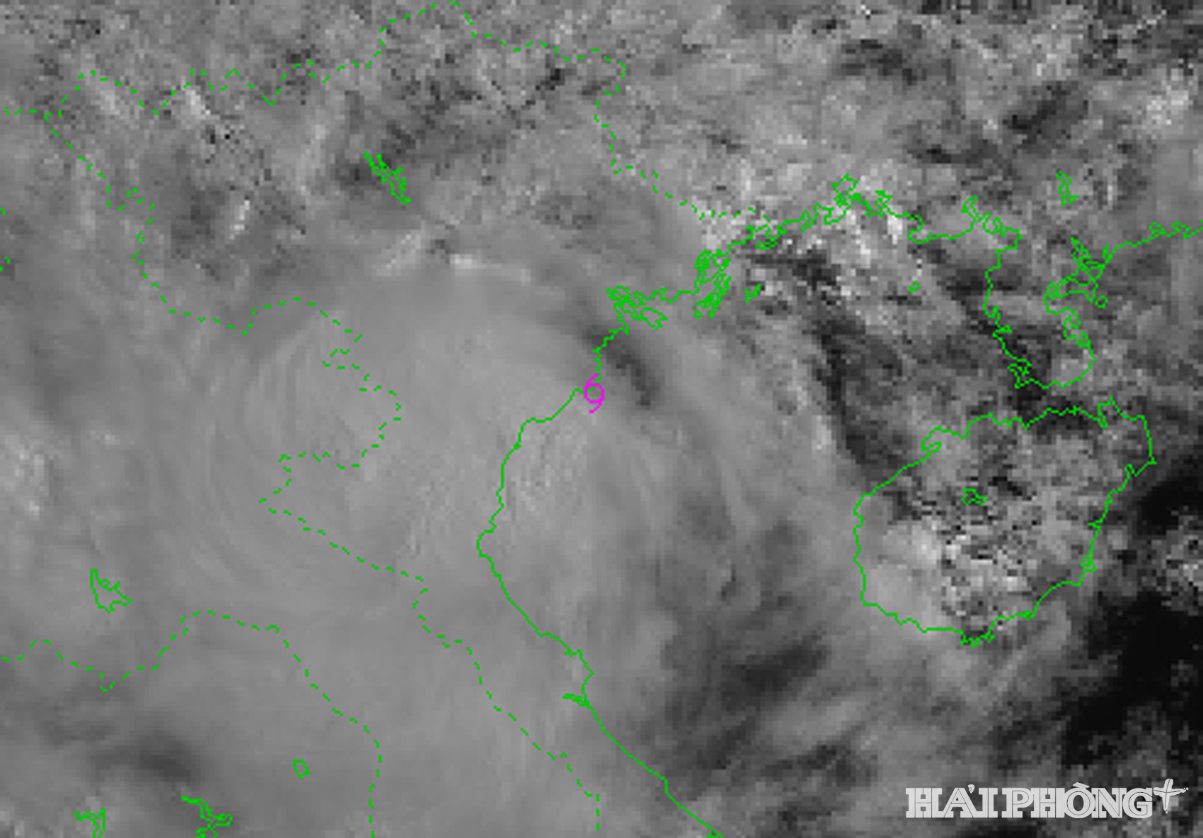
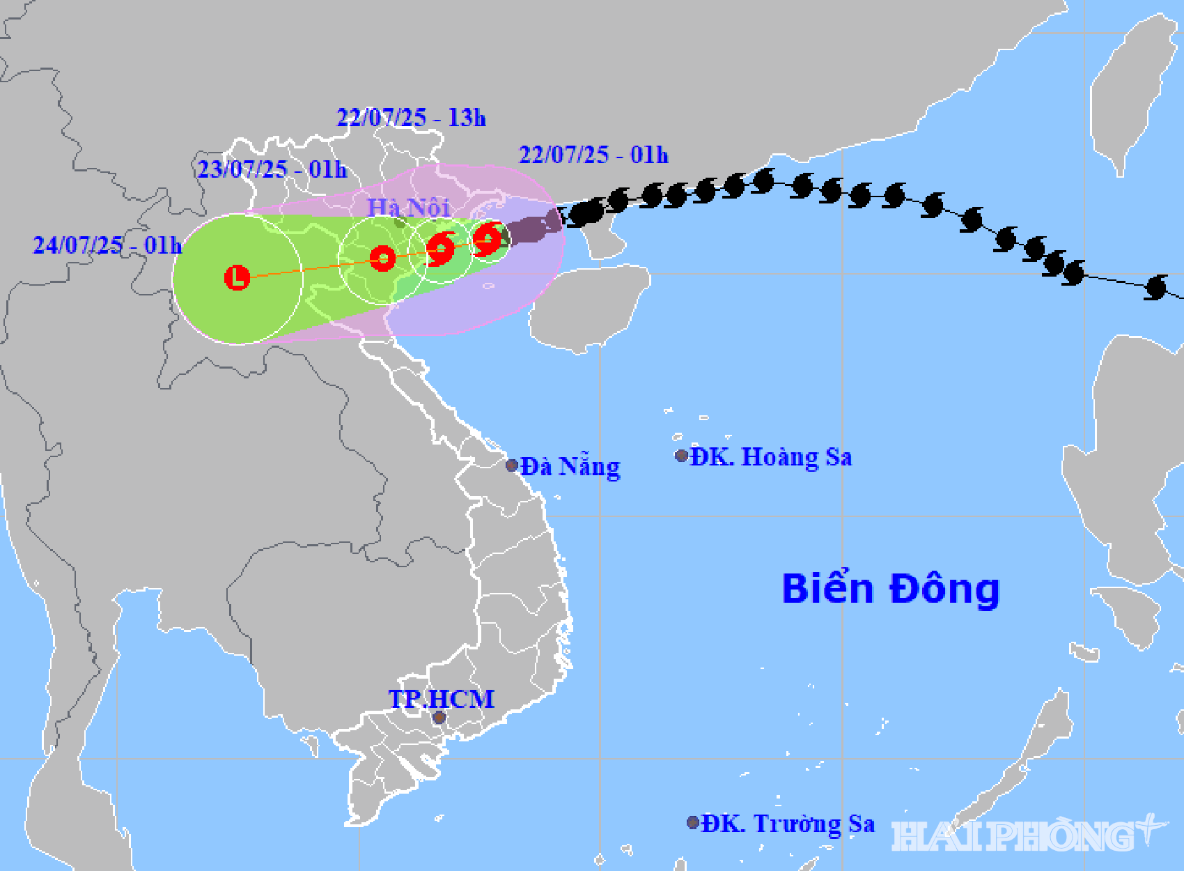
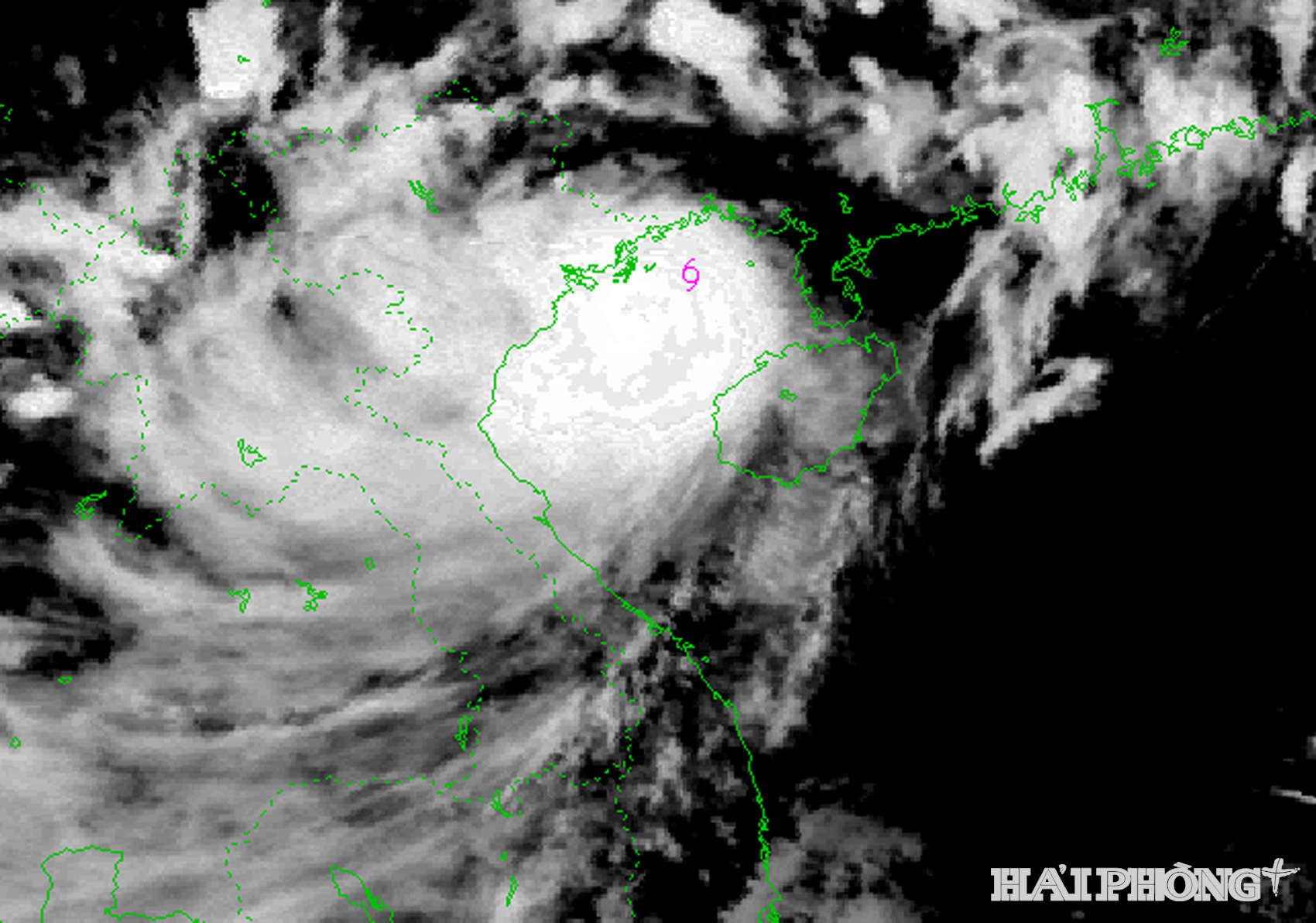
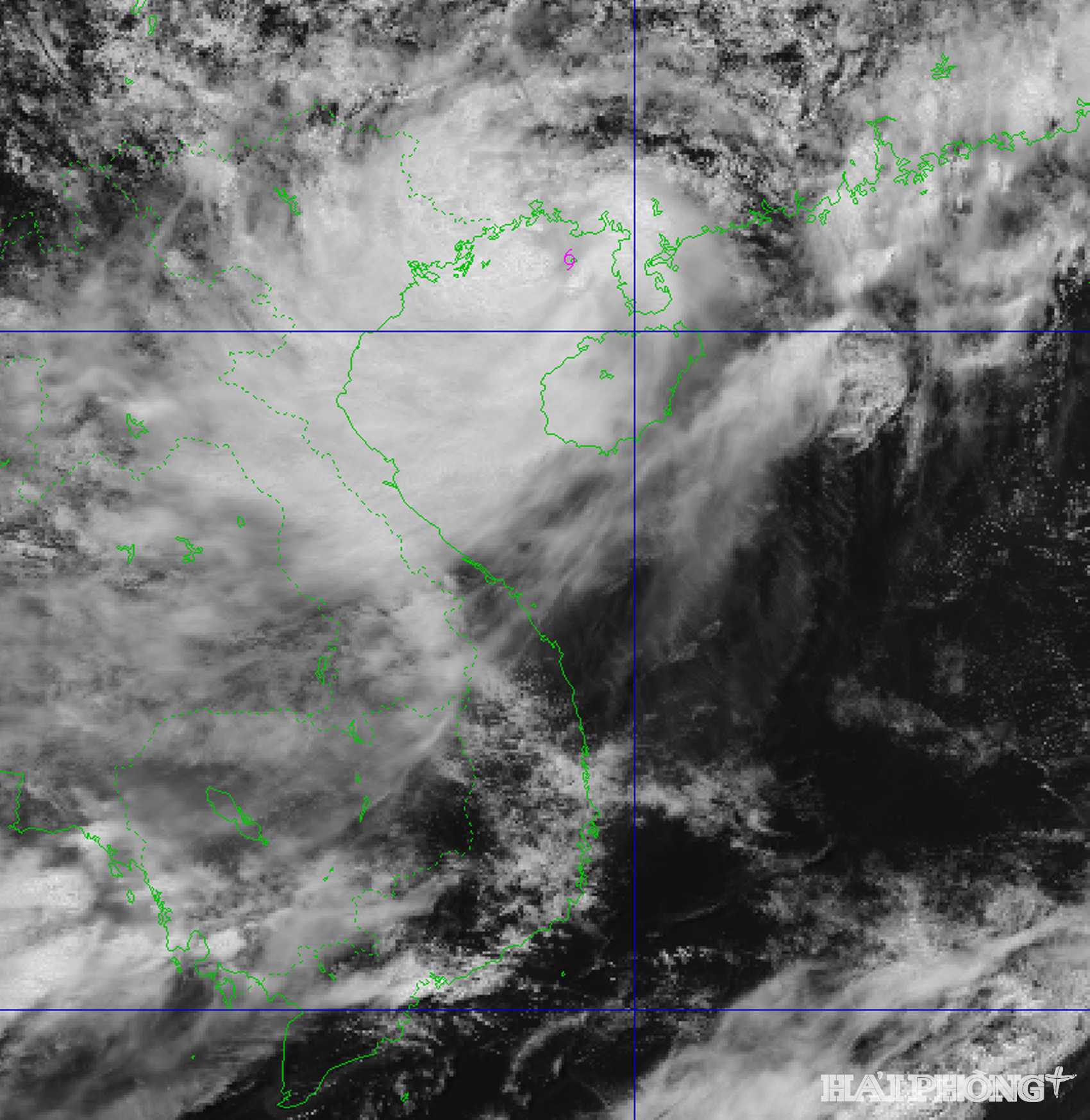
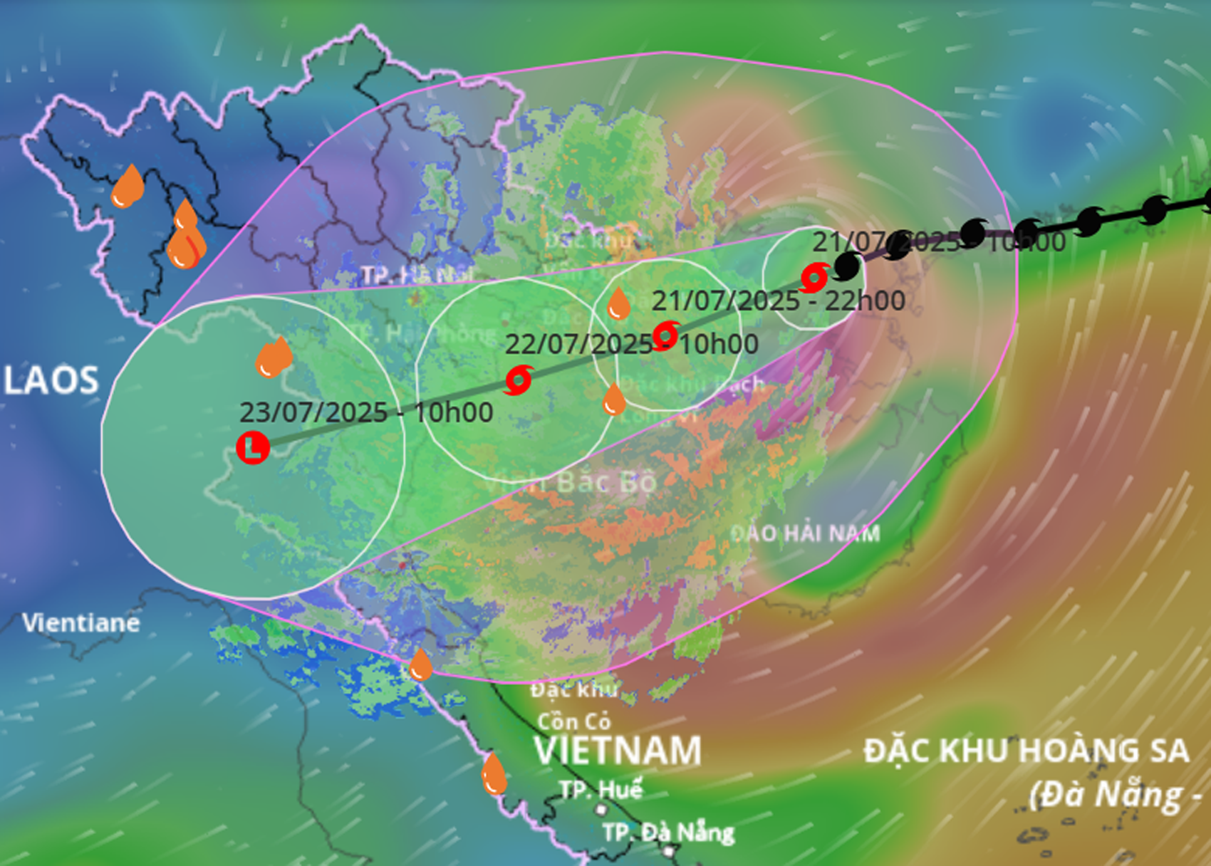
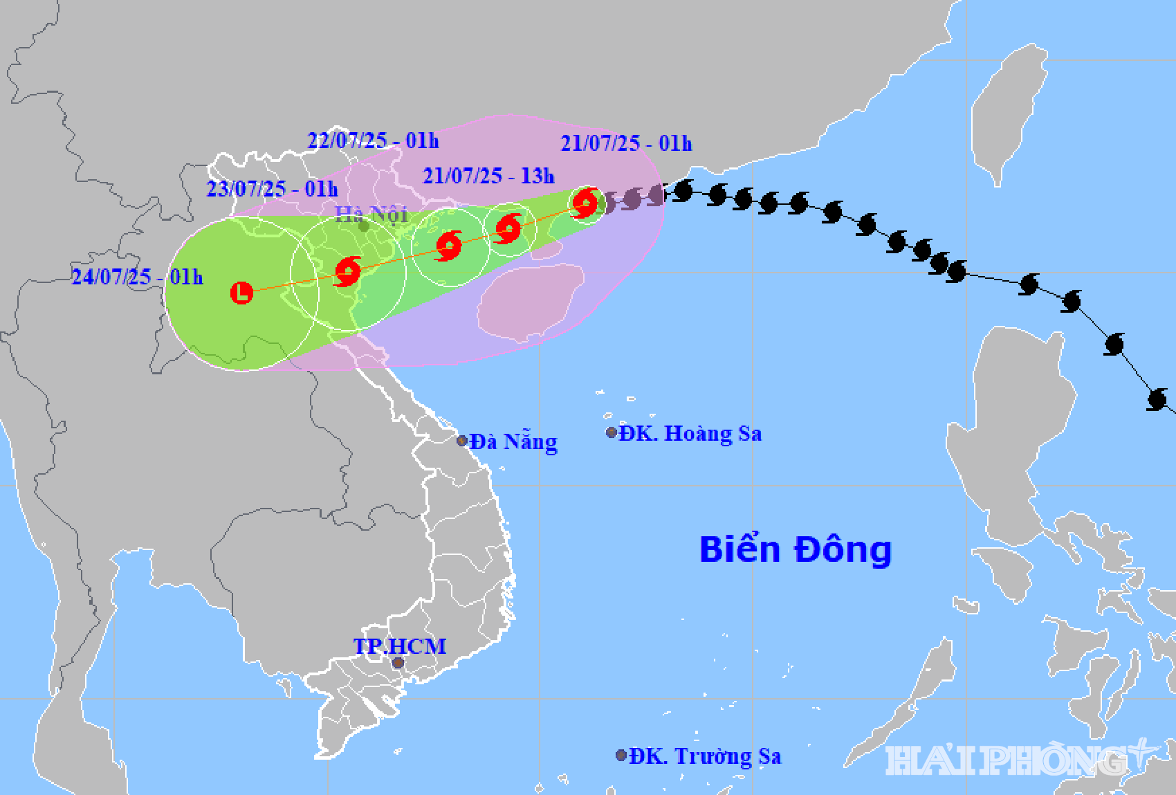
According to the National Center for Hydro-Meteorological Forecasting, at 7:00 p.m. on July 22 , the center of the tropical depression was at about 20.1 degrees north latitude, 105.6 degrees east longitude, on the mainland of the Ninh Binh - Thanh Hoa area. The strongest wind near the center of the tropical depression was level 6 - 7, gusting to level 9.
The tropical depression is forecast to move west-southwest at a speed of about 10 km/h and gradually weaken. By 7:00 a.m. on July 23, the tropical depression weakened into a low pressure area over Upper Laos.
Forecast from tonight and tonight, July 22, in the Gulf of Tonkin (including Bach Long Vi special zone); in the sea of Hai Phong (Cat Hai special zone, Do Son); inland areas including: Thuy Nguyen, Le Chan, Hai An, Duong Kinh, An Duong, An Lao, Kien An, Tien Lang, Vinh Bao, Hai Duong , Chi Linh, Thanh Ha, Kim Thanh, Ninh Giang, Thanh Mien, Cam Giang, Kinh Mon and Tu Ky, there will be rain, moderate rain, locally heavy rain and thunderstorms with common rainfall of 10 - 30 mm. In thunderstorms, there is a possibility of tornadoes, lightning and strong gusts of wind.
.png)
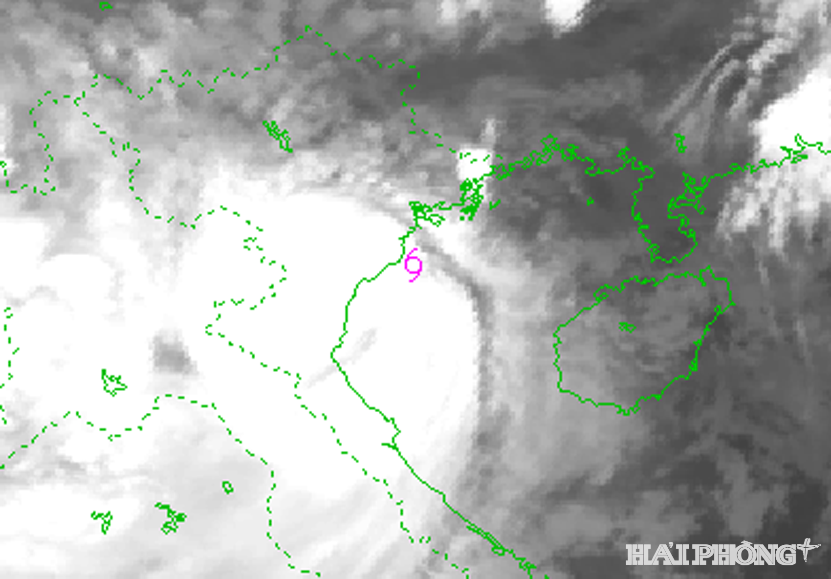
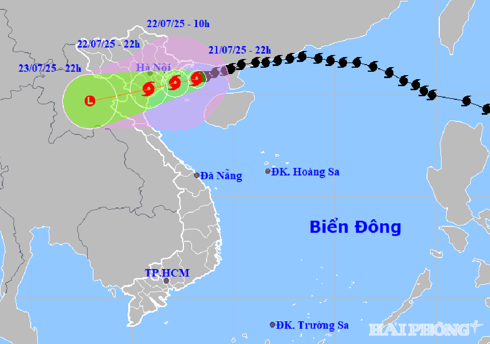
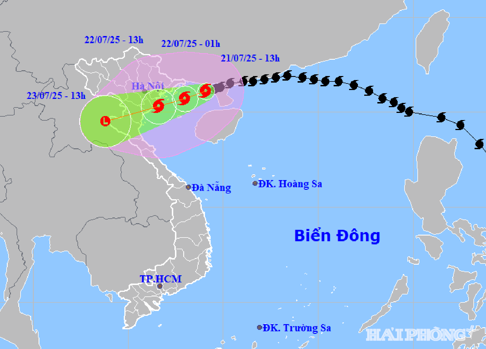
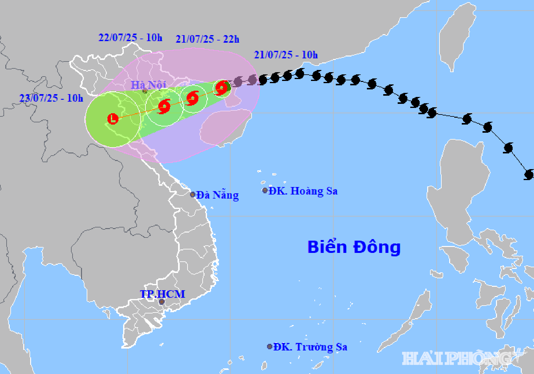
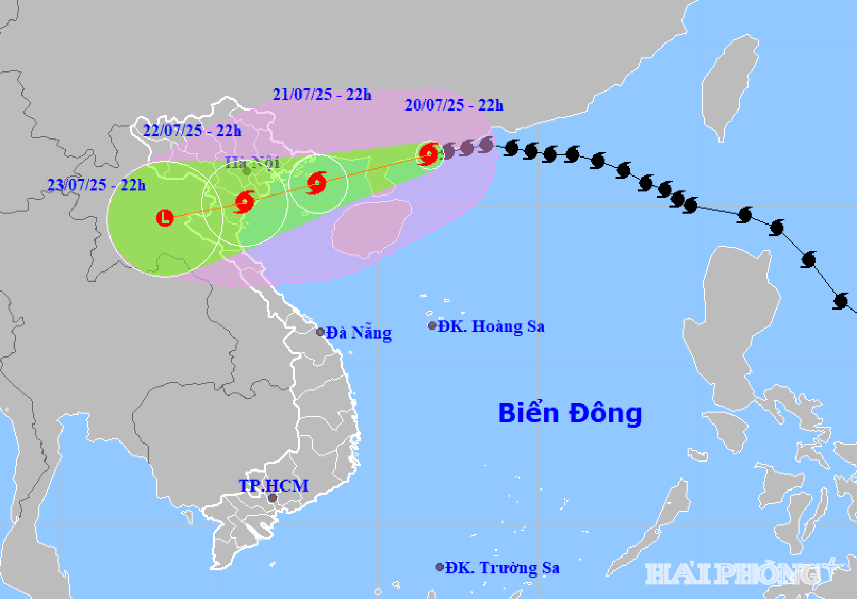
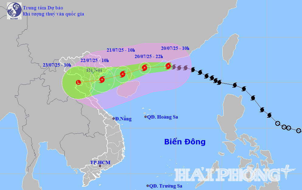
At 4:00 p.m. on July 22 , the center of storm No. 3 (storm WIPHA) was located at about 20.1 degrees north latitude, 105.9 degrees east longitude, on the mainland of Ninh Binh - Thanh Hoa provinces. The strongest wind near the storm center was level 8 (62 - 74 km/h), gusting to level 10.
It is forecasted that in the next 12 hours, storm No. 3 will move slowly in a west-southwest direction and gradually weaken into a tropical depression. By 4:00 p.m. on July 23, the tropical depression will weaken into a low pressure area over the Upper Laos region.
Due to the influence of storm No. 3, at Hon Dau (Hai Phong) at 4:00 p.m. there were strong winds of level 8, gusting to level 10.
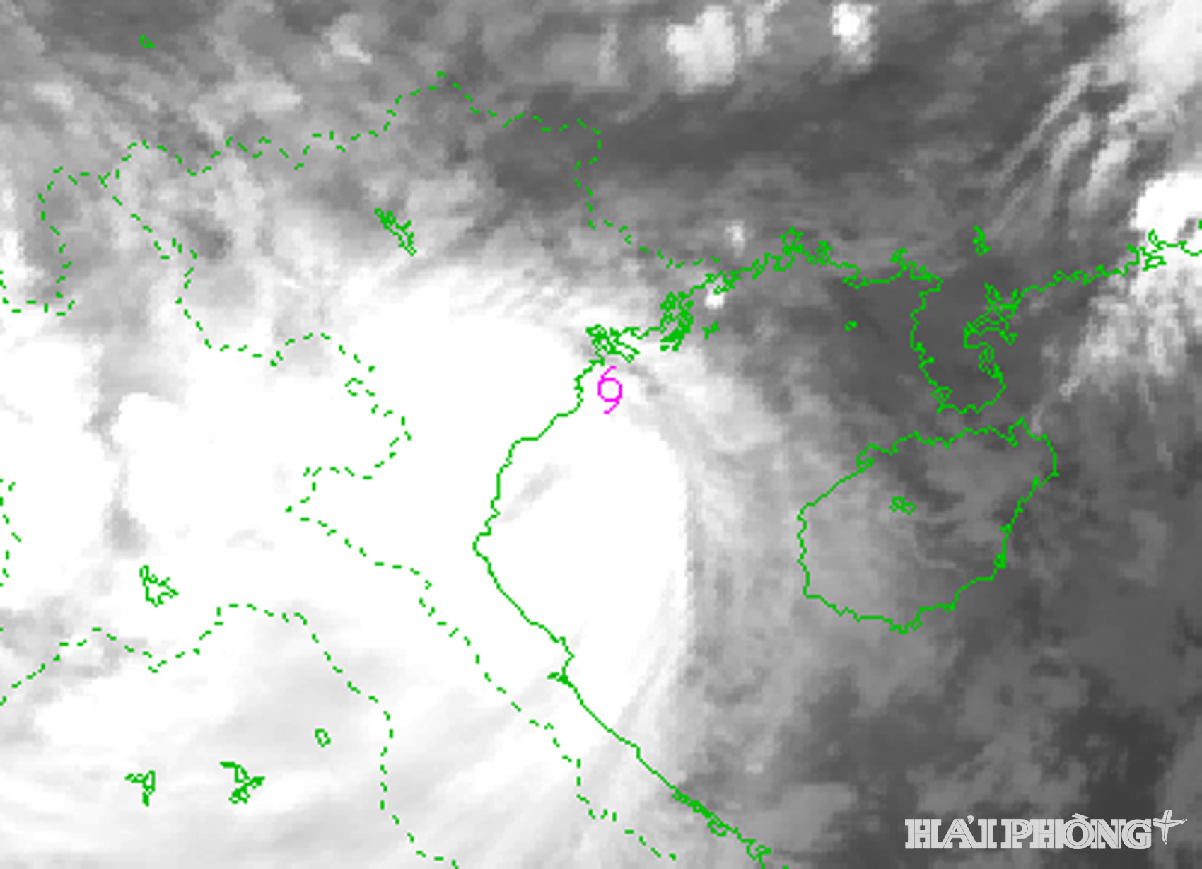
At 1:00 p.m. on July 22 , the center of storm No. 3 was located at about 20.1 degrees north latitude, 106 degrees east longitude, on the mainland of Ninh Binh - Thanh Hoa provinces. The strongest wind near the center of the storm was level 8 (62 - 74 km/h), gusting to level 10, moving west at a speed of 10 - 15 km/h.
It is forecasted that in the next 12 hours, storm No. 3 will move west-southwest at a speed of about 10-15 km/h and gradually weaken into a tropical depression. By 1:00 p.m. on July 23, the tropical depression weakened into a low pressure area over the Upper Laos region.
At 11:00 a.m. on July 22 , the center of storm No. 3 (storm WIPHA) was at about 20.1 degrees north latitude, 106.2 degrees east longitude, on the mainland of Hung Yen - Ninh Binh provinces. The strongest wind near the storm center was level 8 (62 - 74 km/h), gusting to level 10.
It is forecasted that in the next 12 hours, storm No. 3 will move west-southwest at a speed of about 10-15 km/h and gradually weaken into a tropical depression. By 11:00 a.m. on July 23, the tropical depression weakened into a low pressure area over the Upper Laos region.
At 10:00 a.m. on July 22 , the center of storm No. 3 was located at about 20.2 degrees north latitude, 106.4 degrees east longitude, on the mainland along the coast between Hung Yen and Ninh Binh. The strongest wind near the storm center was level 8 - 9 (62 - 88 km/h), gusting to level 11.
It is forecasted that in the next 12 hours, storm No. 3 will move west-southwest at a speed of about 10-15 km/hour and gradually weaken into a tropical depression.
At 9:00 a.m. on July 22 , the center of storm No. 3 was at about 20.2 degrees north latitude, 106.5 degrees east longitude, about 10 km east of Hung Yen (formerly Thai Binh), 25 km northeast of Ninh Binh, and 70 km southeast of Hai Phong . The strongest wind near the center of the storm was level 9 (75 - 88 km/h), gusting to level 11.
It is forecasted that in the next 12 hours, storm No. 3 will move west-southwest at a speed of about 10-15 km/hour and gradually weaken into a tropical depression.
.gif)
At 7:00 a.m. on July 22 , the center of storm No. 3 was located at about 20.2 degrees north latitude, 106.7 degrees east longitude, in the coastal waters of Hai Phong - Ninh Binh. The strongest wind near the center of the storm was level 9 (75 - 88 km/h), gusting to level 12. Storm No. 3 moved west-southwest at a speed of about 15 km/h.
It is forecasted that in the next 12-24 hours, storm No. 3 will continue to move west-southwest at a speed of 10-15 km/h and gradually weaken into a tropical depression. By 7:00 p.m. on July 22, the tropical depression will be on land from Hai Phong to Thanh Hoa, with winds of level 6, gusting to level 8.
At 7:00 a.m. on July 23, the tropical depression weakened into a low pressure area over Upper Laos.
At 6:00 a.m. on July 22 , the center of storm No. 3 was located at about 20.4 degrees north latitude, 106.9 degrees east longitude, about 170 km south-southwest of Quang Ninh, 60 km southeast of Hai Phong, 50 km east of Hung Yen and 70 km northeast of Ninh Binh. The strongest wind near the storm center was level 9 - 10 (89 - 102 km/h), gusting to level 13.
Forecast in the next 3 hours, storm number 3 moves in the west southwest direction, speed about 15 km/hour.
At 4:00 a.m. on July 22 , the center of storm No. 3 was located at about 20.5 degrees north latitude, 107.2 degrees east longitude, about 140 km west southwest of Quang Ninh, 70 km east of Hai Phong, 80 km east northeast of Hung Yen and 100 km northeast of Ninh Binh. The strongest wind near the storm center was level 9 - 10 (75 - 102 km/h), gusting to level 13. Storm No. 3 moved west southwest at a speed of about 15 km/h.
It is forecasted that in the next 12 - 24 hours, storm No. 3 will continue to move west-southwest at a speed of 10 - 15 km/hour. By 4:00 p.m. on July 22, storm No. 3 will be on land from Hai Phong to Thanh Hoa, at level 8, gusting to level 10.
At 4:00 a.m. on July 23, storm No. 3 gradually weakened into a low pressure area over the Vietnam - Laos border area.
At 3:00 a.m. on July 22 , the center of storm No. 3 was located at about 20.6 degrees north latitude, 107.4 degrees east longitude, about 120 km south of Quang Ninh, 90 km east of Hai Phong, 100 km east of Hung Yen northeast and 130 km northeast of Ninh Binh. The strongest wind near the storm center was level 10 (89 - 102 km/h), gusting to level 13.
Forecast in the next 3 hours, storm number 3 moves in the west-southwest direction, speed about 10 - 15 km/hour.
At 1:00 a.m. on July 22 , the center of storm No. 3 was at about 20.7 degrees north latitude, 107.7 degrees east longitude, about 90 km from Quang Ninh, 120 km from Hai Phong, 140 km from Hung Yen and 170 km from Ninh Binh. The strongest wind near the storm center was level 10 (89 - 102 km/h), gusting to level 13. Storm No. 3 moved west-southwest at a speed of about 10 - 15 km/h.
It is forecasted that in the next 12 - 48 hours, storm No. 3 will continue to move west-southwest at a speed of 10 - 15 km/hour. At 1:00 p.m. on July 22, storm No. 3 will be in the coastal waters from Quang Ninh to Ninh Binh (20.5 degrees north latitude, 106.7 degrees east longitude), level 10, gusting to level 13.
At 1:00 a.m. on July 23, storm No. 3 weakened on land from Hai Phong to Thanh Hoa, with intensity of level 6, gusting to level 10.
At 1:00 a.m. on July 24, storm No. 3 gradually weakened into a low pressure area over Upper Laos.
At 10:00 p.m. on July 21 , the center of storm No. 3 was at about 20.8 degrees north latitude, 108.2 degrees east longitude, about 80 km east-southeast of Quang Ninh, 180 km east of Hai Phong, 190 km from Hung Yen and 220 km east-northeast of Ninh Binh. The strongest wind near the center of the storm was level 10 (89 - 102 km/h), gusting to level 13. Storm No. 3 moved west-southwest at a speed of about 10 km/h.
It is forecasted that in the next 12-48 hours, storm No. 3 will continue to move west-southwest at a speed of 10 km/h and is likely to strengthen. At 10:00 a.m. on July 22, storm No. 3 will be in the sea area from Quang Ninh to Ninh Binh (20.6 degrees north latitude, 107.1 degrees east longitude), level 11, gusting to level 14.
At 10:00 p.m. on July 22, storm No. 3 on the mainland of Hai Phong - Thanh Hoa provinces, level 8, gust level 10.
By 10 p.m. on July 23, storm No. 3 gradually weakened into a low pressure area over Upper Laos.
At 9:00 p.m. on July 21 , the center of storm No. 3 was at approximately 20.9 degrees north latitude, 108.3 degrees east longitude, approximately 70 km east-southeast of Quang Ninh, 190 km east of Hai Phong, 210 km east of Hung Yen and 240 km east-northeast of Ninh Binh. The strongest wind near the center of the storm was level 10 (89 - 102 km/h), gusting to level 13.
Forecast in the next 3 hours, storm number 3 moves in the west southwest direction, speed about 10 km/hour.
.gif)
At 7:00 p.m. on July 21 , the center of storm No. 3 was at about 20.9 degrees north latitude, 108.5 degrees east longitude, about 90 km from Quang Ninh, 210 km east of Hai Phong; 230 km from Hung Yen, 260 km east northeast of Ninh Binh. The strongest wind near the center of the storm was level 9 - 10 (75 - 102 km/h), gusting to level 13. Storm No. 3 moved west-southwest at a speed of about 10 km/h.
It is forecasted that in the next 12 - 48 hours, storm No. 3 will continue to move west-southwest at a speed of 10 - 15 km/h and is likely to strengthen. At 7:00 a.m. on July 22, storm No. 3 will be in the sea area from Quang Ninh to Ninh Binh (20.7 degrees north latitude, 107.3 degrees east longitude), with winds of level 10 - 11, gusts of level 14.
At 7:00 p.m. on July 22, storm No. 3 on the mainland of Hai Phong - Thanh Hoa provinces, level 9, gust level 11.
By 7:00 p.m. on July 23, storm No. 3 gradually weakened into a low pressure area over Upper Laos.
At 4:00 p.m. on July 21 , the center of storm No. 3 was at about 20.9 degrees north latitude, 108.7 degrees east longitude, about 100 km from Quang Ninh, 220 km east of Hai Phong; 240 km from Hung Yen, 270 km east northeast of Ninh Binh. The strongest wind near the storm center was level 9 - 10 (75 - 102 km/h), gusting to level 12. Storm No. 3 moved west-southwest at a speed of about 15 km/h.
It is forecasted that in the next 12 - 48 hours, storm No. 3 will continue to move west-southwest at a speed of 10 - 15 km/h and is likely to strengthen. At 4:00 a.m. on July 22, storm No. 3 will be in the northern area of Bac Bo Gulf (20.7 degrees north latitude, 107.6 degrees east longitude), with winds of level 10 - 11, gusts of level 14.
At 4:00 p.m. on July 22, storm No. 3 weakened when it made landfall in the coastal area from Hai Phong to Thanh Hoa, with a level 9-10 wind speed, gusting to level 13.
By 4:00 p.m. on July 23, storm No. 3 gradually weakened into a low pressure area over Upper Laos.

At 3:00 p.m. on July 21 , the center of storm No. 3 was at about 20.9 degrees north latitude, 108.8 degrees east longitude, about 110 km from Quang Ninh, 230 km east of Hai Phong; 250 km from Hung Yen, 275 km east northeast of Ninh Binh. The strongest wind near the center of the storm was level 9 - 10 (75 - 102 km/h), gusting to level 12.
Forecast in the next 3 hours, storm number 3 moves in the west southwest direction, speed about 15 km/hour.
At 1:00 p.m. on July 21 , the center of storm No. 3 was at about 21.1 degrees north latitude, 109.1 degrees east longitude, about 120 km from Quang Ninh, 260 km east of Hai Phong; 280 km from Hung Yen, 310 km east-northeast of Ninh Binh. The strongest wind near the center of the storm was level 9 - 10 (75 - 102 km/h), gusting to level 12.
Storm No. 3 moves west southwest, speed about 10 - 15 km/hour.
It is forecasted that in the next 12 - 48 hours, storm No. 3 will continue to move west-southwest at a speed of 10 - 15 km/h and is likely to strengthen. At 1:00 a.m. on July 22, storm No. 3 will be in the northern area of Bac Bo Gulf (20.7 degrees north latitude, 108 degrees east longitude), with winds of level 10 - 11, gusts of level 14.
At 1:00 p.m. on July 22, storm No. 3 was in the sea from Hai Phong to Thanh Hoa, level 10-11, gusting to level 14.
By 1 p.m. on July 23, storm No. 3 gradually weakened into a low pressure area over Upper Laos.
At 12:00 on July 21 , the center of storm No. 3 was at about 21.1 degrees north latitude, 109.3 degrees east longitude, about 140 km from Quang Ninh, 280 km east of Hai Phong; 300 km from Hung Yen, 330 km east-northeast of Ninh Binh. The strongest wind near the center of the storm was level 9 - 10 (75 - 102 km/h), gusting to level 12.
Thus, storm number 3 has increased by 1 level compared to 10:00 a.m. the same day.
Forecast in the next 3 hours, storm number 3 moves in the west southwest direction, speed about 15 km/hour.
At 10:00 a.m. on July 21 , the center of storm No. 3 was at about 21.2 degrees north latitude, 109.6 degrees east longitude, about 190 km from Quang Ninh, 310 km east of Hai Phong; about 340 km from Hung Yen, about 360 km east northeast of Ninh Binh. The strongest wind near the storm center is level 9 (75 - 88 km/h), gusting to level 11. Storm No. 3 moves west-southwest, at a speed of about 10 - 15 km/h.
It is forecasted that in the next 12 - 48 hours, storm No. 3 will continue to move west-southwest at a speed of 10 - 15 km/h and is likely to strengthen. By 10:00 p.m. on July 21, storm No. 3 will be in the northern area of Bac Bo Gulf (20.7 degrees north latitude, 108.2 degrees east longitude), with winds of level 10 - 11, gusts of level 14.
At 10:00 on July 22, storm number 3 was in the sea from Hai Phong - Thanh Hoa, level 10 - 11, gust level 14.
At 10:00 a.m. on July 23, storm No. 3 weakened into a low pressure area over Upper Laos.

At 9:00 a.m. on July 21 , the center of storm No. 3 was located at about 21.3 degrees north latitude, 109.7 degrees east longitude, in the northern area of Leizhou Peninsula (China), about 200 km east of Quang Ninh - Hai Phong. The strongest wind near the center of the storm is level 9 (75 - 88 km/h), gusting to level 11. In the next 3 hours, storm No. 3 will move west-southwest at a speed of about 15 - 20 km/h.
It is forecasted that when entering the Gulf of Tonkin, storm No. 3 will strengthen before weakening near land.
At 7:00 a.m. on July 21 , the center of storm No. 3 was located at about 21.3 degrees north latitude, 109.9 degrees east longitude, in the northern area of Leizhou peninsula (China), about 220 km east of Quang Ninh - Hai Phong. The strongest wind near the center of the storm was level 9 (75 - 88 km/h), gusting to level 11. The storm moved west-southwest at a speed of about 15 - 20 km/h.
It is forecasted that in the next 24 - 72 hours, storm No. 3 will continue to move west-southwest at a speed of 10 - 15 km/h and is likely to strengthen. At 7:00 a.m. on July 22, storm No. 3 will be in the northern area of Bac Bo Gulf, level 10 - 11, gusting to level 14.

At 7:00 a.m. on July 23, storm No. 3 gradually weakened into a tropical depression on the mainland of Thanh Hoa - Nghe An provinces, with winds of level 6 and gusts of level 9.
At 7:00 a.m. on July 24, the tropical depression weakened into a low pressure area over Upper Laos.
At 6:00 a.m. on July 21 , the center of storm No. 3 was located at about 21.3 degrees north latitude, 110 degrees east longitude, in the northern area of Leizhou Peninsula (China), about 233 km east of Quang Ninh - Hai Phong. The strongest wind near the center of the storm was level 9 (75 - 88 km/h), gusting to level 11.
Forecast in the next 3 hours, storm number 3 moves in the west-southwest direction, speed 15 - 20 km/hour.
At 4:00 a.m. on July 21 , the center of storm No. 3 was located at about 21.5 degrees north latitude, 110.4 degrees east longitude, in the northern area of Leizhou peninsula (China), about 275 km east of Quang Ninh - Hai Phong. The strongest wind near the center of the storm was level 9 (75 - 88 km/h), gusting to level 11. The storm moved west-southwest at a speed of 15 - 20 km/h.
It is forecasted that in the next 24 - 72 hours, storm No. 3 will continue to move west-southwest at a speed of 15 km/hour. At 4:00 a.m. on July 22, storm No. 3 will be in the northern area of Bac Bo Gulf, level 10 - 11, gusting to level 14.
At 4:00 a.m. on July 23, storm No. 3 gradually weakened into a tropical depression on the mainland of Hung Yen - Thanh Hoa provinces, with winds of level 6 - 7, gusts of level 9.
At 4:00 a.m. on July 24, the tropical depression weakened into a low pressure area over Upper Laos.
At 1:00 a.m. on July 21 , the center of storm No. 3 was located at about 21.6 degrees north latitude, 111.1 degrees east longitude, on the mainland southwest of Guangdong province (China), about 350 km east of Quang Ninh - Hai Phong. The strongest wind near the center of the storm was level 9 (75 - 88 km/h), gusting to level 11. The storm moved west-southwest at a speed of 15 - 20 km/h.
It is forecasted that in the next 24 - 72 hours, storm No. 3 will continue to move west-southwest at a speed of 15 km/hour. At 1:00 a.m. on July 22, storm No. 3 will be in the northern area of Bac Bo Gulf, level 11, gusting to level 14.
At 1:00 a.m. on July 23, storm No. 3 made landfall in Hung Yen - Thanh Hoa provinces and weakened to level 8, gusting to level 10.
At 1:00 a.m. on July 24, storm No. 3 weakened into a low pressure area over Upper Laos.
At 10:00 p.m. on July 20 , the center of storm No. 3 was located at about 21.6 degrees north latitude, 111.6 degrees east longitude, in the northwest sea of the northern East Sea, about 407 km east of Quang Ninh - Hai Phong. The strongest wind near the storm center is level 10 (89 - 102 km/h), gusting to level 12. In the next 3 hours, the storm will move west-southwest at a speed of about 15 - 20 km/h.
It is forecasted that in the next 24 - 72 hours, storm No. 3 will move west-southwest at a speed of 15 - 20 km/hour. By 10:00 p.m. on July 21, storm No. 3 will be in the northern Gulf of Tonkin, with winds of level 11 - 12, gusting to level 15.
At 10:00 p.m. on July 22, storm No. 3 entered the mainland along the coast of Hai Phong - Thanh Hoa and weakened to level 9, gusting to level 11.
At 10:00 p.m. on July 23, storm No. 3 weakened into a low pressure area over Upper Laos.

At 9:00 p.m. on July 20 , the center of storm No. 3 was located at about 21.6 degrees north latitude, 111.7 degrees east longitude, in the northwest sea of the northern East Sea, about 418 km east of Quang Ninh - Hai Phong. The strongest wind near the storm center is level 10 - 11 (89 - 117 km/h), gusting to level 14. In the next 3 hours, the storm will move west-southwest at a speed of about 20 - 25 km/h.
The Japan Meteorological Agency and Hong Kong Radio both predict that storm No. 3 will pass north of the Leizhou Peninsula (China) and enter the Gulf of Tonkin without weakening, maintaining winds of about 108 km/h. The storm's eye is expected to make landfall in the provinces from Quang Ninh to Ninh Binh, including Hai Phong.
At 7:00 p.m. on July 20 , the center of storm No. 3 was located at about 21.7 degrees north latitude, 112.2 degrees east longitude, in the northwest sea of the northern East Sea, about 480 km east of Quang Ninh - Hai Phong. The strongest wind near the storm center was level 11 (103 - 117 km/h), gusting to level 14. The storm moved westward at a speed of about 20 km/h.
It is forecasted that in the next 24 - 72 hours, storm No. 3 will continue to move west, then turn west-southwest at a speed of 20 - 25 km/hour. At 7:00 p.m. on July 21, storm No. 3 will be in the northern area of Bac Bo Gulf, level 11 - 12, gusting to level 15.
At 7:00 p.m. on July 22, storm No. 3 entered the mainland along the coast of Hai Phong - Thanh Hoa and weakened to level 9 - 10, gusting to level 12.
At 7:00 p.m. on July 23, storm No. 3 weakened into a low pressure area over Upper Laos.

At 6:00 p.m. on July 20 , the center of storm No. 3 was located at about 21.8 degrees north latitude, 112.5 degrees east longitude, in the northern sea area of the North East Sea, about 526 km east of Quang Ninh - Hai Phong. The strongest wind near the center of the storm is level 11 - 12 (103 - 133 km/h), gusting to level 15. In the next 3 hours, the storm will move westward at a speed of 20 - 25 km/h.
.gif)
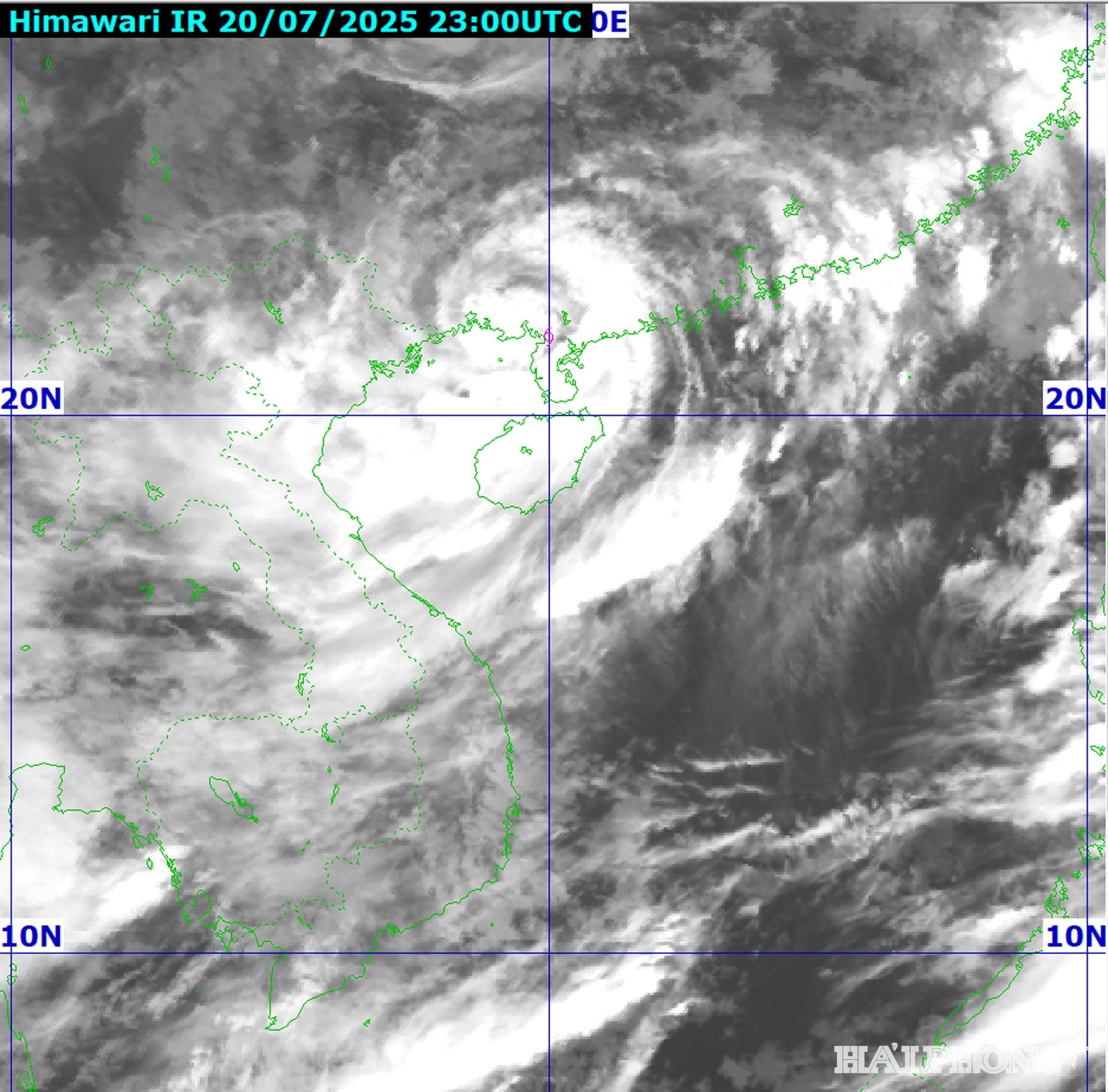
At 4:00 p.m. on July 20 , the center of storm No. 3 (storm WIPHA) was located at about 21.8 degrees north latitude, 112.8 degrees east longitude, in the northern sea area of the North East Sea, about 560 km east of Quang Ninh - Hai Phong. The strongest wind near the storm center is level 12 (118 - 133 km/h), gusting to level 15. The storm is moving westward at a speed of 20 - 25 km/h.
It is forecasted that in the next 24 - 72 hours, storm No. 3 will continue to move west, then turn west-southwest at a speed of 20 - 25 km/hour. At 4:00 p.m. on July 21, storm No. 3 will be in the northern area of Bac Bo Gulf (20.7 degrees north latitude, 108.5 degrees east longitude), with a strength of level 11 - 12, gusting to level 15.
At 4:00 p.m. on July 22, the storm entered the mainland along the coast of Hai Phong - Thanh Hoa and weakened to level 9 - 10, gusting to level 12.
At 4:00 p.m. on July 23, storm No. 3 weakened into a low pressure area over Upper Laos.
At 3:00 p.m. on July 20 , the center of storm No. 3 was located at about 21.8 degrees north latitude, 113 degrees east longitude, in the northern sea area of the North East Sea, about 521 km east of Mong Cai (Quang Ninh). The strongest wind near the center of the storm was level 12 (118 - 133 km/h), gusting to level 15. In the next 3 hours, the storm will move west at a speed of 20 - 25 km/h.
.gif)
At 1:00 p.m. on July 20 , the center of storm No. 3 was located at about 21.9 degrees north latitude, 113.4 degrees east longitude, in the northern sea area of the North East Sea, about 630 km east of Quang Ninh - Hai Phong. The strongest wind near the center of the storm was level 12 (118 - 133 km/h), gusting to level 15. The storm moved west at a speed of 20 - 25 km/h.
It is forecasted that in the next 24 - 72 hours, storm No. 3 will continue to move west, then turn west-west at a speed of 20 - 25 km/hour. At 13:00 on July 21, the storm was at about 20.8 degrees north latitude, 108.9 degrees east longitude, in the eastern sea area of the northern Gulf of Tonkin. Intensity level 11 - 12, gust level 15.
At 1:00 p.m. on July 22, the storm was in the coastal area of Quang Ninh - Thanh Hoa. Intensity level 10 - 11, gust level 14.
At 1:00 p.m. on July 23, storm No. 3 gradually weakened into a low pressure area over Upper Laos.
At 10:00 a.m. on July 20 , the center of storm No. 3 was located at about 21.8 degrees north latitude, 114.2 degrees east longitude, in the northern sea area of the North East Sea, about 680 km east of Quang Ninh - Hai Phong. The strongest wind near the center of the storm was level 11 - 12 (103 - 133 km/h), gusting to level 15. Storm No. 3 is moving west at a speed of 20 - 25 km/h.
It is forecasted that in the next 24 - 72 hours, storm No. 3 will continue to move west, then turn west-southwest at a speed of 20 - 25 km/hour. At 10:00 on July 21, the center of storm No. 3 is in the eastern sea area of the northern Gulf of Tonkin. Winds near the center of the storm are at level 11, gusting to level 14.
At 10:00 a.m. on July 22, the storm center entered the coastal area from Quang Ninh to Thanh Hoa. The storm's wind intensity was level 10 - 11, gusting to level 14.
Ready to respond to heavy rain due to the impact of storm No. 3

Forecasting that storm No. 3 (storm WIPHA) will cause heavy rain, Hai Phong Drainage One Member Co., Ltd. requested units operating pumping stations and tide-prevention sluices to regulate and lower water levels in ditches and lakes; test-run pumps to ensure good operation in all conditions when there is heavy rain caused by the storm.
Clear all drainage outlets, collect garbage at the manholes; remove duckweed and obstacles in the ditches and regulating lakes; prepare auxiliary flaps and sandbags at the tide-preventing sluices; prepare all available equipment, cranes, mobile pumps with a capacity of 1,000 m3/hour; arrange sludge suction trucks and pipeline cleaning trucks to be ready during the storm. Workers at the pumping stations work 24/7 according to assigned shifts...
In order to promptly and quickly direct the work of preventing flooding due to the impact of storm No. 3, the company has developed a detailed plan for each department and unit to deploy the task of operating the urban drainage system during the time the storm affects the mainland and after the storm has dissipated. Establish 3 inspection teams for storm prevention work before, during and after the storm, continuously reviewing and checking key areas for flooding until the storm is over.
Source: https://baohaiphongplus.vn/bao-so-3-tan-tren-bien-gioi-viet-nam-lao-416803.html


![[Infographic] Vietnam-Senegal traditional friendship](https://vphoto.vietnam.vn/thumb/1200x675/vietnam/resource/IMAGE/2025/7/23/4c96a604979345adb452af1d439d457b)


Comment (0)