

Associate Professor, Dr. Mai Van Khiem - Director of the National Center for Hydro-Meteorological Forecasting (Department of Hydro-Meteorology, Ministry of Agriculture and Environment ), said that this morning the flood in all rivers has peaked and is receding.
Sharing with reporters of VietnamPlus Electronic Newspaper, at 7:00 a.m. on October 10, the Director of the National Center for Hydro-Meteorological Forecasting said that in Hanoi , the water level of Cau River peaked at 10.16m at 11:00 p.m. on October 9, Ca Lo River peaked at 9.75m at 4:00 a.m. today (October 10) and is changing slowly.
At 6:00 a.m. this morning, the water level on the Cau River at Luong Phuc station was 10.12 m (2.12 m above alert level 3). The water level on the Ca Lo River at Manh Tan station was 9.74 m (1.74 m above alert level 3).
It is forecasted that in the next 12 - 24 hours, the water level on Cau River and Ca Lo River will slowly decrease and fluctuate at level 3 above alarm level 3 from 1.3 - 1.8m.
With the above developments, the National Center for Hydro-Meteorological Forecasting warns of the risk of flooding and the possibility of other accompanying natural disasters.
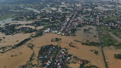
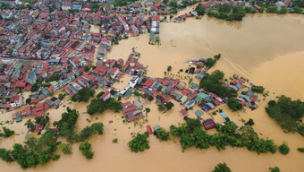
Specifically, the water level on Cau River and Ca Lo River is at a high level, causing flooding in low-lying areas, floating flats in the middle of the river, and riverside areas with a depth of 0.2-0.6m, in some places it is deeper than 0.6m; the flooding period can last 2-4 days, in some places it is longer.
For the "hot spots" of flooding in recent days, such as Thai Nguyen province, the flood on Cau River is also receding.
The water level at 6:00 a.m. on Cau River (Thai Nguyen) at Cha station was 11.50m - 1.50m above alert level 3 (0.48m above historical flood level).
It is forecasted that in the next 12-24 hours, the flood on Cau River at Cha station will continue to decrease and fluctuate at level above alert 3. With this development, the flooding situation is likely to last for the next 2-3 days and the flooding depth will gradually decrease.
In Bac Ninh, the flood on Cau River and Thuong River is currently receding slowly. The water level at 6am on Cau River at Dap Cau station was 7.49m (1.19m above alarm level 3); at Phuc Loc Phuong it was 9.93m (1.93m above alarm level 3; 0.53m above historical level).
Similarly, the water level on the Thuong River at Cau Son at 6:00 a.m. was 17.48 m (1.48 m above alarm level 3); at Phu Lang Thuong it was 7.52 m (1.22 m above alarm level 3).
It is forecasted that in the next 6-24 hours, floods on Cau River and Thuong River will continue to slowly recede and fluctuate at level 3 above alert level, with Phuc Loc Phuong station above historical flood level.
According to the National Center for Hydro-Meteorological Forecasting, the process of flood drainage and reduction on rivers is slow, the water withdrawal time is prolonged. For areas that do not actively drain, the possibility of flooding is longer, so flooding still occurs in low-lying areas, low-lying areas along rivers, and alluvial areas outside the main dike.
In Lang Son province, at 1:00 a.m., Huu Lung station on the Trung River recorded a water level of 22.11 m (3.11 m above alert level 3, 0.41 m below the historical flood level). It is forecasted that in the next 6 - 24 hours, the flood on the Trung River will continue to decrease and fluctuate at a level above alert level 3.
The National Center for Hydro-Meteorological Forecasting said that the flood on the Trung River is receding but remains at a high level, potentially causing flooding in low-lying areas along the river, landslides, riverbank erosion, inundation and affecting the safety of works along rivers, streams and vulnerable points such as high slopes.
Source: https://baolaocai.vn/cac-song-o-bac-bo-lu-da-dat-dinh-dang-xuong-nhung-nguy-co-ngap-van-tiep-dien-post884152.html


![[Photo] "Exposing letters" in the flood center of Lang Son](https://vphoto.vietnam.vn/thumb/1200x675/vietnam/resource/IMAGE/2025/10/10/1760080117518_ndo_br_z7101324112737-07cd4d1c01801a8ccf4ae0cbaf31c4a3-507-jpg.webp)
![[Photo] Standing member of the Secretariat Tran Cam Tu works with the Standing Committee of the Party Committee of the Ministry of Health](https://vphoto.vietnam.vn/thumb/1200x675/vietnam/resource/IMAGE/2025/10/10/1760079818773_image-4-6972-jpg.webp)
![[Photo] Prime Minister Pham Minh Chinh attends the Patriotic Emulation Congress of Hanoi city](https://vphoto.vietnam.vn/thumb/1200x675/vietnam/resource/IMAGE/2025/10/10/1760078918257_dsc-2008-jpg.webp)


![[Photo] President Luong Cuong presents decisions on conferring titles and appointing Vietnamese Ambassadors](https://vphoto.vietnam.vn/thumb/402x226/vietnam/resource/IMAGE/2025/10/10/1760082105623_image-1.jpeg)


Comment (0)