
Weather experts explain that while Thanh Hoa and Nghe An are experiencing torrential rain and many places are isolated due to landslides, the north of the center of storm number 3 is experiencing light rain and sunny skies.
This afternoon, storm number 3 Wipha weakened and made landfall in the provinces of Ninh Binh - Thanh Hoa. The strongest wind near the storm's center is level 8 (62-74km/h), gusting to level 10. In the next 24 hours, the storm will continue to weaken into a tropical depression, then a low pressure area in the Upper Laos region.
This morning, before storm No. 3 made landfall in our country, while Thanh Hoa and Nghe An had torrential rain, many places were isolated due to landslides and flooding, the weather in Hanoi and some northern provinces and cities had light rain and light winds. In the early afternoon, there were times when some places were sunny.
Regarding the rain characteristics of storm No. 3, Mr. Mai Van Khiem - Director of the National Center for Hydro-Meteorological Forecasting said that the cloud area is mainly concentrated in the western circulation and the southwestern part of the storm, so since yesterday, July 21, when the storm was in the northern part of the Gulf of Tonkin, the northeastern provinces, coastal areas, and the southern area of the Northern Delta, including Hanoi, have had heavy rain.
When the eye of the storm moves to the coastal area of Hung Yen - Ninh Binh, the main rain areas will be in the provinces of Ninh Binh, Hung Yen, Thanh Hoa, Nghe An, Ha Tinh, and Hanoi. The provinces in the northern part of the storm's circulation still have intermittent rain but the rainfall is not as heavy as the southern part of the storm's circulation. In Hanoi, there are even times when the weather is sunny.
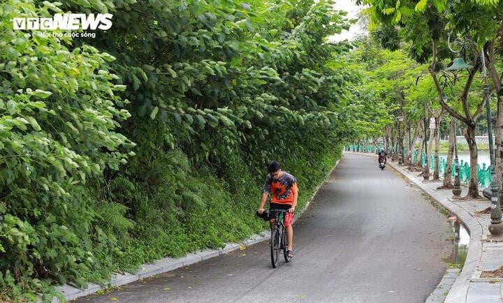
This afternoon, many areas in Hanoi are sunny (Photo: Minh Duc)
However, according to the forecast of the National Center for Hydro-Meteorological Forecasting, satellite imagery, lightning location data and weather radar images show that the cloud area in the north of the storm's circulation continues to exist over wards and communes in Hanoi: Yen Bai, Doai Phuong, Phuc Tho, Ba Vi, O Dien... and Phu Thuong, Xuan Dinh, Dong Ngac, Nghia Do... This cloud area will continue to exist in the next few hours and tends to move with the storm.
In the next 4 hours, the above wards in Hanoi's inner city will have rain, showers and possibly thunderstorms. The thunderstorm area may expand to other wards in Hanoi's inner city. During the rain, there is a possibility of tornadoes, lightning and strong gusts of wind.
It is forecasted that from the evening of July 22 to the morning of July 23, Thanh Hoa, Nghe An, southern Phu Tho and Son La will experience heavy to very heavy rain with common rainfall of 40-100mm, some places over 200mm. There is a risk of heavy rain over 150mm in just 3 hours.
From the evening of July 22 to the afternoon of July 23, other places in the North and Ha Tinh will have rain, moderate rain, locally heavy rain with rainfall of 20-40mm, some places over 100mm.
In the evening and night of July 22, the Central Highlands and the South will have scattered showers and thunderstorms, locally heavy rain with rainfall of 10-30mm, in some places over 70mm.
Source: https://baolangson.vn/chuyen-gia-ly-giai-hien-tuong-phia-bac-tam-bao-so-3-giam-mua-troi-hung-nang-5053921.html


![[Infographic] Vietnam-Senegal traditional friendship](https://vphoto.vietnam.vn/thumb/1200x675/vietnam/resource/IMAGE/2025/7/23/4c96a604979345adb452af1d439d457b)


Comment (0)