
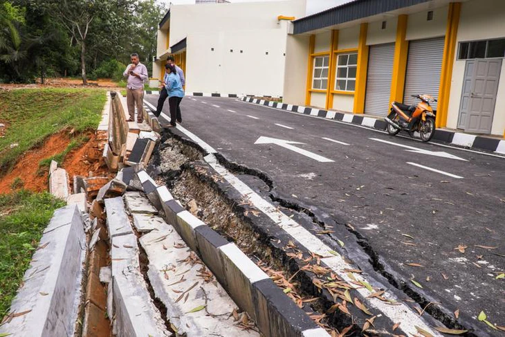
Although not located in the Pacific Ring of Fire, Malaysia is still at risk of earthquakes - Photo: IPROPERTY
According to The Star news site on March 31, Malaysian experts warned that Malaysia is still at risk of being affected by earthquakes even though it is not located in the Pacific Ring of Fire, calling on the government and people to be more vigilant.
Always be alert for earthquakes
Although Malaysia is not located on a collision zone between major tectonic plates, small tremors have been recorded over the decades, so it is important to be vigilant when earthquakes occur in neighboring countries, such as the recent quake in Myanmar, said Abd Rasid Jaapar, president of the Institute of Geology of Malaysia.
In particular, the risk of earthquakes is higher in Sabah state due to the area's proximity to seismically active zones, where the collision of two tectonic plates under the Pacific Ocean frequently occurs, as well as movements along active faults.
History shows that Malaysia has experienced strong earthquakes, especially in Sabah with magnitudes ranging from 6.0 to 6.3 in 1923, 1958, 1976 and 2015. Several earthquakes have also occurred in Peninsular Malaysia, with magnitudes ranging from 1.6 to 4.6 in the period 1984 - 2013.
In response to this warning, Chairman of the Malaysian Bumiputera Contractors Association, Datuk Azman Yusoff, said that most new high-rise buildings in Malaysia in the past decade were built to earthquake-resistant standards, including Eurocode 8.
A notable feature of Eurocode 8 is the use of spring dampers, which allow buildings to “isolate” their foundations from ground movements. This flexibility helps absorb seismic energy and reduces the risk of structural collapse during an earthquake.
In addition, Director-General of the National Disaster Management Agency Datuk Khairul Shahril Idrus said that the Malaysian Special Disaster Assistance and Relief Team (SMART) is always on standby and regularly conducts disaster response drills in high-risk areas such as Mount Kinabalu (Malaysia's highest mountain) in Sabah state.
Earthquake hazard maps and tsunami warning systems
The Malaysian Meteorological Department is currently operating 80 seismic sensors to monitor and detect earthquakes. In addition, 83 tsunami warning sirens (SAATNM) have been deployed in vulnerable areas, capable of relaying earthquake warnings within 8 minutes of detecting a signal.
Dr Khamarrul Azahari Razak, director of the Centre for Disaster Preparedness and Response at the University of Technology Malaysia (UTM), stressed the need to improve coordination between rescue agencies and emergency response teams.
According to him, the Malaysian Government needs to consider effective evacuation strategies, coordinated rapid response and measures to protect the people, especially in moving large numbers of people to safer areas when disasters occur.
Previously in 2015, the 6.0 magnitude earthquake in Sabah, the strongest ever recorded in the region, killed 18 people.
In 2019, the Ministry of Mineral Resources and Earth Sciences (JMG) introduced the earthquake hazard map of Peninsular Malaysia, the states of Sabah and Sarawak (east Malaysia) to mitigate risks associated with earthquakes.
The map serves as a reference for earthquake-resistant building designs by classifying hazard zones based on the peak ground acceleration (PGA) method, thereby ensuring greater safety for construction works in Malaysia.
Source: https://tuoitre.vn/chuyen-gia-malaysia-canh-bao-nong-sau-dong-dat-o-myanmar-20250401093930499.htm
![[Photo] The 1st Government Party Congress held a preparatory session.](https://vphoto.vietnam.vn/thumb/1200x675/vietnam/resource/IMAGE/2025/10/12/1760257471531_dsc-4089-jpg.webp)


![[Photo] Delegation attending the Government Party Congress visited President Ho Chi Minh's Mausoleum](https://vphoto.vietnam.vn/thumb/1200x675/vietnam/resource/IMAGE/2025/10/12/1760240068221_dsc-3526-jpg.webp)
![[Photo] National Assembly Chairman Tran Thanh Man attends the 725th anniversary of the death of National Hero Tran Hung Dao](https://vphoto.vietnam.vn/thumb/1200x675/vietnam/resource/IMAGE/2025/10/12/1760285740475_ndo_br_bnd-8978-jpg.webp)


Comment (0)