
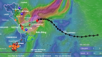
According to information from the National Center for Hydro-Meteorological Forecasting, at 7:00 a.m. on October 20, the center of storm No. 12 was at about 17.8 degrees North latitude, 116.9 degrees East longitude, about 490km East Northeast of Hoang Sa special zone. The strongest wind near the center of the storm was level 9 (75-88km/h), gusting to level 11, the storm moved northwest at a speed of about 25km/h. At 7:00 a.m. on October 21, storm No. 12 was at position 18.4N-112.7E, about 180km north of Hoang Sa special zone, with the potential to strengthen, level 11, gusts of level 13. At 7:00 a.m. on October 22, storm No. 12 was at position 17.2N-110.7E, in the sea northwest of Hoang Sa special zone, intensity of level 10-11, gusts of level 13.
Due to the influence of storm circulation and cold air combined with East wind disturbances and terrain effects, from October 22-27, the area from Ha Tinh to Quang Ngai is likely to have widespread heavy rain, lasting for many days, with some areas having very heavy rain, high risk of flash floods and landslides in mountainous areas, flooding in low-lying areas and urban areas. Localities need to prepare response plans for flood scenarios on rivers from Quang Tri to Quang Ngai that are likely to reach alert level 3 and exceed alert level 3.
Forecasting the level of natural disaster risk due to floods and inundations at level 3. Implementing the direction in Official Dispatch No. 18/CD-BCĐ-BNNMT dated October 19, 2025 of the National Civil Defense Steering Committee on responding to storm No. 12, to proactively respond to the developments of storm No. 12, ensuring the safety of people's lives, property of the State and people, the Minister of Industry and Trade requests Heads of units in the Industry and Trade sector to focus on implementing the following key tasks:
See details of the telegram here .
Source: https://moit.gov.vn/tin-tuc/thong-bao/cong-dien-ve-viec-trien-khai-ung-pho-voi-bao-so-12-fengshen-.html

![[Photo] National Assembly Chairman Tran Thanh Man holds talks with Hungarian National Assembly Chairman Kover Laszlo](https://vphoto.vietnam.vn/thumb/1200x675/vietnam/resource/IMAGE/2025/10/20/1760952711347_ndo_br_bnd-1603-jpg.webp)
![[Photo] Prime Minister Pham Minh Chinh meets with Speaker of the Hungarian National Assembly Kover Laszlo](https://vphoto.vietnam.vn/thumb/1200x675/vietnam/resource/IMAGE/2025/10/20/1760970413415_dsc-8111-jpg.webp)
![[Photo] Chairman of the Hungarian Parliament visits President Ho Chi Minh's Mausoleum](https://vphoto.vietnam.vn/thumb/1200x675/vietnam/resource/IMAGE/2025/10/20/1760941009023_ndo_br_hungary-jpg.webp)


Comment (0)