

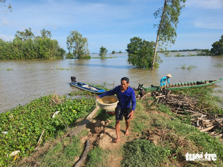
An Giang province's hydrometeorological station forecasts that the flood peak will appear on October 10, with the water level on the Tien River at Tan Chau possibly reaching 3.8m, 0.2m below alert level 1 - Photo: BUU DAU
Accordingly, in the upstream area of Tien River and Hau River (An Giang province), due to the influence of upstream floods and low tides in the downstream area, the water level is rising, the highest water level on October 5 on Tien River at Tan Chau station is 3.53m, 0.03m above alert level 1, on Hau River at Chau Doc station is 3.02m, 0.02m above alert level 1.
It is forecasted that due to the influence of flood water from the upper Mekong River, combined with the high tide of the 15th day of the 8th lunar month, water levels at stations in the upstream areas of the Tien and Hau rivers will continue to rise in the coming days.
The highest water level this time is likely to appear on October 8-10 (from August 17-19 of the lunar calendar). The peak flood level on the Tien River at Tan Chau is likely to reach 3.8m, 0.2m below alert level 2; on the Hau River at Khanh An at 4.9m, 0.2m above alert level 2, and at Chau Doc at 3.5m, equivalent to alert level 2.
It is forecasted that the flood peak may fall on October 10, on the Tien River at Tan Chau, the water level may reach 3.8m, 0.2m below alert level 2. On the Hau River at Chau Doc, the water level may reach 3.5m, equivalent to alert level 2.
Due to the impact of high tides in the lower reaches of the river combined with floods in the upper reaches of the Mekong River and heavy rain in the region, there is a possibility of flooding and local inundation in some low-lying areas, riverside areas, canals, roads and areas with low ground elevation, areas without dike systems, and weak culverts in the urban area in the two wards of Long Xuyen and Binh Duc and the two communes of My Hoa Hung and Cho Moi.
People in Thoi Son ward said that this year's flood season has less fish and shrimp than the same period last year - Photo: BUU DAU
Flood risk warning level, disaster risk level on Tien River at Tan Chau is level 1. Disaster risk level on Hau River at Khanh An is level 2. Disaster risk level on Hau River at Chau Doc is level 1.
Warning of the impact of floods on rivers that can cause flooding in low-lying areas along rivers, riverbank erosion affecting activities such as transportation, aquaculture, agricultural production, people's lives and socio- economic activities.
Source: https://tuoitre.vn/dinh-lu-mien-tay-co-the-dat-3-8m-tren-song-tien-duoi-bao-dong-2-20251006195238936.htm

![[Photo] Parade to celebrate the 50th anniversary of Laos' National Day](/_next/image?url=https%3A%2F%2Fvphoto.vietnam.vn%2Fthumb%2F1200x675%2Fvietnam%2Fresource%2FIMAGE%2F2025%2F12%2F02%2F1764691918289_ndo_br_0-jpg.webp&w=3840&q=75)
![[Photo] Worshiping the Tuyet Son statue - a nearly 400-year-old treasure at Keo Pagoda](/_next/image?url=https%3A%2F%2Fvphoto.vietnam.vn%2Fthumb%2F1200x675%2Fvietnam%2Fresource%2FIMAGE%2F2025%2F12%2F02%2F1764679323086_ndo_br_tempimageomw0hi-4884-jpg.webp&w=3840&q=75)


Comment (0)