
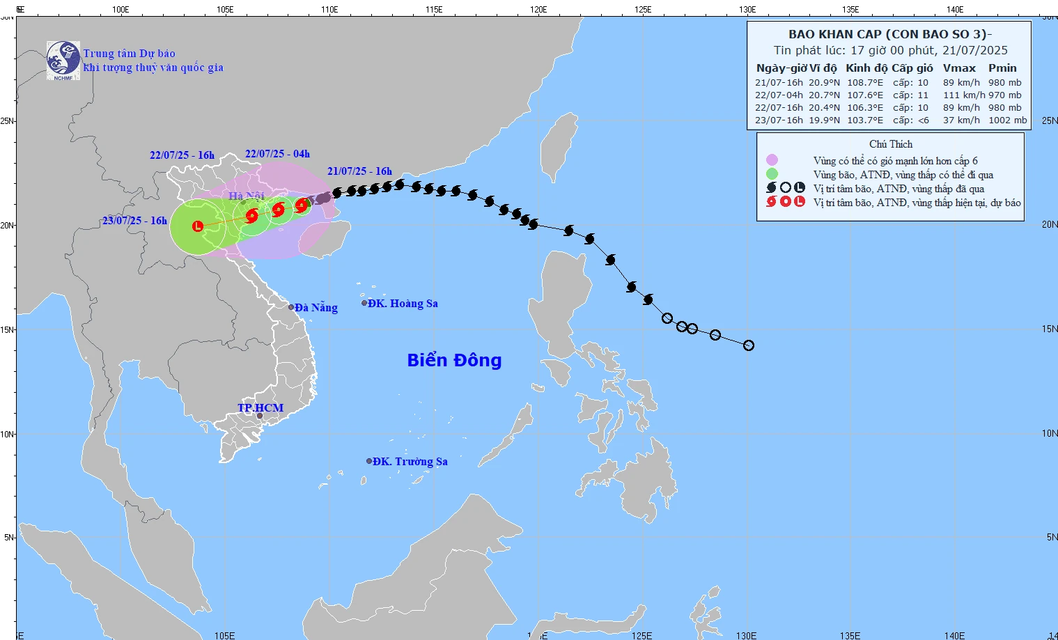
Forecast of storm No. 3's path issued at 5:00 p.m. on July 21, 2025.
Specifically, the center of the storm is located at about 21 degrees North latitude; 108.7 degrees East longitude, about 100km from Quang Ninh, about 220km East of Hai Phong , about 240km from Hung Yen, about 270km East Northeast of Ninh Binh. The strongest wind is level 9-10 (75-102 km/h), gusting to level 12.
Due to the impact of storm No. 3, Bach Long Vi special zone had strong winds of level 8, gusting to level 9; Co To and Cat Hai special zones had strong winds of level 6, gusting to level 7.
Forecast by 4am tomorrow (July 22), the storm center is over the North Gulf of Tonkin, level 10-11, gust level 14, likely to strengthen. By 4pm, the storm center is over the mainland along the coast of Hai Phong - Thanh Hoa , level 9-10, gust level 13
At 4:00 p.m. on July 23, the storm center was over Upper Laos and weakened into a low pressure area.
Forecast of impact of storm number 3 At sea: - Northwest North East Sea: wind level 7-8, gust level 10, waves 3-5m high, rough sea. - Northern Gulf of Tonkin (Bach Long Vi, Co To, Van Don, Cat Hai, Hon Dau): wind level 6-7, increasing to level 8-9, near the storm center level 10-11, gust level 14; waves 2-4m high, near the center 4-6mm; rough seas. - Southern Bac Bo Gulf (Hon Ngu): wind level 6-7, near the storm center level 8-9, gust level 11; waves 2-4m high; very rough seas. On land: From the night of July 21, winds will gradually increase to level 7-9, near the storm center level 10-11, gusting to level 14 on the coast of Quang Ninh - Nghe An . Hai Phong, Hung Yen, Bac Ninh, Hanoi, Ninh Binh, Thanh Hoa have wind level 6, gusting to level 7-8. From the evening of July 21-23, the Northeast, Northern Delta, Thanh Hoa, Nghe An: heavy to very heavy rain, commonly 200-350mm, in some places over 600mm. Other places in the North and Ha Tinh: rain 100-200mm, some places over 300mm. Risk of heavy rain >150mm/3h. Warning: Flash floods, landslides, flooding in low-lying areas. Risk of flooding in coastal areas and river mouths on the afternoon of July 22. Winds of level 10-11 can cause trees, electric poles, and roofs to fall. |
NDS
Source: https://baothanhhoa.vn/du-bao-16h-ngay-22-7-bao-vao-dat-lien-ven-bien-hai-phong-thanh-hoa-255602.htm


![[Photo] National Assembly Chairman Tran Thanh Man visits Vietnamese Heroic Mother Ta Thi Tran](https://vphoto.vietnam.vn/thumb/1200x675/vietnam/resource/IMAGE/2025/7/20/765c0bd057dd44ad83ab89fe0255b783)


Comment (0)