
The Central Highlands is a region susceptible to drought and water shortages due to the decline in groundwater resources. Irrigation works can only supply water to a part of the irrigated area, the rest mainly depends on rainwater. In recent times, this region has experienced many droughts and water shortages, causing tens to hundreds of thousands of hectares of crops to be affected and damaged.
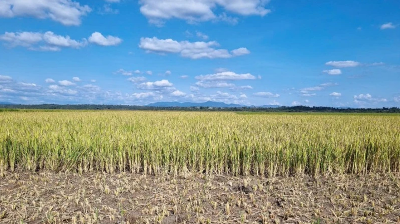 Illustrative photo: Drought has damaged many rice fields in Dak Doa district ( Gia Lai ). (Photo: HOANG HUNG - DINH SY TAO)
The Central Highlands has a total agricultural land area of about more than one million hectares, mainly perennial crops such as coffee, pepper, cocoa, cashew, etc. In addition, there are some areas for growing rice, annual crops and other perennial crops. However, this is also an area that is easily affected by drought and water shortage because the current irrigation works only provide irrigation water for about 25% of the area that needs irrigation, while about 75% of the area that needs irrigation depends on rainwater. The peak of drought in the Central Highlands is from February to April every year. Years with severe drought are mainly due to the previous year's rainy season ending early and the following year's rainy season appearing late and prolonged hot weather; cultivation is not based on the balance of water resources.
Director of the Department of Management and Construction of Irrigation Works ( Ministry of Agriculture and Environment ) Nguyen Tung Phong said: “In the past 25 years, there have been 17 droughts in the Central Highlands provinces, each affecting an area of crops ranging from 30,000 to 60,000 hectares, the most serious being in 2015-2016 with 338,547 hectares of crops damaged. Drought and local water shortages for about 10,000 to 20,000 hectares of crops occur almost every year.”
Drought and local water shortages for about 10,000 to 20,000 hectares of crops occur almost every year.
Director of Department of Management and Construction of Irrigation Works (Ministry of Agriculture and Environment) Nguyen Tung Phong
In the Central Highlands, the current area of underground aquifers is 34.21 thousand km2 with a storage capacity of 6.22 billion m3 and an average annual exploitation volume of about 0.5 billion m3. Underground water resources are about 9.44 billion m3 with exploitable water reserves of about 3.55 billion m3. However, from 2010 to 2020, the groundwater level in the region has decreased from 20 to 50 cm. The main reason is that people dig wells for agricultural production and daily life, affecting the underground water system as well as the geological structure, while the source of groundwater recharge is decreasing.
According to the Department of Management and Construction of Irrigation Works , in the context of climate change, surface water sources from reservoirs, rivers, and streams are reduced, and rain is erratic and unevenly distributed, which will affect the groundwater recharge in this area. Therefore, it will more or less affect the assurance of irrigation water for crops, especially industrial crops here.
In recent years, to serve the direction and management of water supply for agricultural production, the Ministry of Agriculture and Rural Development (now the Ministry of Agriculture and Environment) has assigned the Department of Irrigation (now the Department of Irrigation Works Management and Construction) to organize the implementation of the task of forecasting water resources and developing water use plans, serving the direction and management of water supply for agricultural production in river basins in the Central Highlands.
The task performed is to monitor water resources in irrigation works, assess drought and water shortage situations; at the same time, regularly provide weekly, monthly and seasonal water resource bulletins for localities to develop plans for water supply for production. However, with the specificity that 75% of the production area is outside the service area of irrigation works, water resources depend mainly on rain, so the management of drought and water shortage in this area is currently facing many difficulties. Specifically: The diversity in large-scale agricultural production makes it difficult to identify crop areas that have been and are being affected by drought and water shortage over time.
In addition, the calculation, forecasting, and warning of drought and water shortage are mainly carried out for areas within the scope of active water supply from irrigation works. For areas dependent on rainwater, the calculation and assessment are mainly based on drought, meteorological, and hydrological indicators, which are very volatile and difficult to forecast in the long term.
Therefore, the project to assess the impact of drought in the Central Highlands, which will be piloted in Dak Nong and Dak Lak provinces in 2025, funded by the Food and Agriculture Organization of the United Nations (FAO) from non-refundable ODA, is expected to help Vietnam develop methods to monitor and forecast droughts and water shortages, ensuring irrigation water for agricultural production in this region based on remote sensing technology, displaying results via a portal/website. The project also supports the development of a plan to use water for safer and more efficient production.
The project uses the WaPOR Level 3 tool developed by FAO to analyze satellite imagery at different resolutions, allowing for assessments of water productivity, severity of droughts, water shortages and sustainability of agricultural activities. This platform effectively supports state management of irrigation, irrigation, drought prevention and water shortages, and supports decision-making to enhance water security and agricultural resilience.
Director of the Department of Management and Construction of Irrigation Works Nguyen Tung Phong said: “This is a pilot model for the Ministry of Agriculture and Environment to replicate nationwide, as a basis for responding to the impacts of climate change, improving the efficiency of exploiting irrigation works. However, because the project uses satellite image interpretation methods to assess drought and water shortage, the results depend largely on algorithms and field verification data. In addition, it is very difficult to count water use because it is mainly household production scale, using many irrigation water sources (surface water, groundwater). Due to the diversity in production, crop distribution depends on changes in agricultural markets, requiring remote sensing data verification to require regional understanding and need to be carefully designed in the implementation plan”.
To effectively implement the project, the Department of Irrigation Construction and Management will closely coordinate with FAO and implementing experts; closely coordinate with localities in collecting and verifying satellite image interpretation data; receive maximum technology transfer from the project to proactively apply annual drought and water shortage forecasting for the Central Highlands region. From the results obtained from the project, the Department will continue to propose to FAO for support to expand the project results to other regions of Vietnam.
Source: https://baodaknong.vn/du-bao-han-han-thieu-nuoc-dua-tren-cong-nghe-vien-tham-251321.html


![[Infographic] In 2025, 47 products will achieve national OCOP](https://vphoto.vietnam.vn/thumb/402x226/vietnam/resource/IMAGE/2025/7/16/5d672398b0744db3ab920e05db8e5b7d)


Comment (0)