

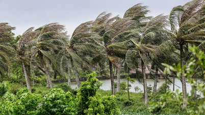
People in the capital need to proactively respond to unusual situations of strong winds, heavy rains, urban flooding and the risk of flooding on rivers. Illustrative photo
From this evening (July 21), Hanoi began to be affected by storm No. 3 with strong winds of level 5-6, gusts of level 7-8, heavy to very heavy rain; risk of widespread flooding and landslides.
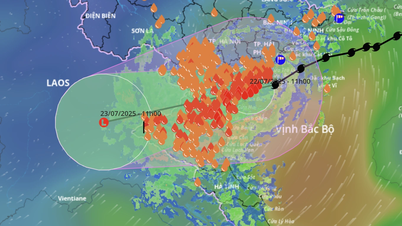
According to the National Center for Hydro-Meteorological Forecasting, at 4:00 p.m. on July 21, storm No. 3 was about 100 km from Quang Ninh province and about 240 km from Hanoi. The storm moved west-southwest at a speed of about 15 km/h, with the strongest winds near the storm's center at level 9-10 (75-102 km/h), gusting to level 12.
It is forecasted that by 4:00 a.m. on July 22, the storm's center will be in the northern Gulf of Tonkin, with a level 10-11 strength and gusts of level 14. By 4:00 p.m. on July 22, the storm will make landfall in the provinces from Hai Phong to Thanh Hoa, continue to move inland and gradually weaken on July 23.
Due to the storm's influence, from the evening and night of July 21, the southern and central areas of Hanoi, such as Ha Dong, Thanh Xuan, Hoang Mai, Hoan Kiem, Ba Dinh, Tu Liem... had winds of level 5, sometimes level 6, gusting to level 7-8. The communes of Xuan Mai, Son Tay, Hoa Lac, Quoc Oai, Ba Vi... had strong winds of level 4-5, gusting to level 6.
Regarding rain, from the evening of July 21 to 23, the whole city will have moderate to heavy rain. Rainfall is generally 100-200mm, areas such as Chuong My, Phu Xuyen, Van Dinh can reach 150-250mm, with some areas exceeding 300mm.
From the night of July 23 to July 25, the city will continue to have moderate to heavy rain. Floods with amplitudes of 1.5-3.5m are likely to occur on inland rivers such as the Bui River, Tich River, Ca Lo River, and Day River. Water levels may exceed alert level 2 in some areas, causing flooding in riverside communes such as Tran Phu, Quang Bi, Xuan Mai, My Duc, Hoa Xa, etc.
The meteorological agency warned that with many high-rise buildings in Hanoi, the wind acceleration effect when the wind flows through these areas can make the actual wind much stronger than recorded at the monitoring station. People are advised to limit going outside during strong winds to ensure safety.
According to the analysis of the National Center for Hydro-Meteorological Forecasting, in the inner city area, the flooding depth can be from 0.2m to 0.5m, deeper in some places; local flooding lasts from 30 minutes to 1 hour before the water recedes. Areas along rivers, weak ground, steep terrain, and important drainage culverts need special attention.
Regarding the risk of flooding and local isolation, a representative of the National Center for Hydro-Meteorological Forecasting said: Up to now, the amount of rainfall recorded in Hanoi is not large, and no areas have been identified as experiencing severe flooding. However, special vigilance is needed for unusually heavy rain after the storm. This is the beginning to the middle of the storm season, when atmospheric humidity is high, and tropical convergence zones can easily form after the storm has dissipated, which can continue to cause widespread heavy rain.
In response to the above forecast, Chairman of the Hanoi People's Committee Tran Sy Thanh issued a telegram requesting departments, branches, units and localities to proactively and synchronously deploy the "4 on-site" plan; inspect and review all vulnerable points and high-risk areas. Units must complete the consolidation of the Commune Civil Defense Command, especially in the post-merger communes, ensuring that there are no vacant on-site command positions in the event of storms and prolonged heavy rain.
To protect life and property, people in the capital need to pay attention, check corrugated iron roofs, fibro-cement roofs, windows, doors; firmly tie down houses, temporary tents, livestock barns; trim large tree branches, check the drainage system around the house, avoid blockages causing local flooding; move motorbikes and cars to safe places; cover furniture that is easily wet or damaged...
When there are strong winds and heavy rains, people should avoid areas with old trees, construction sites, and billboards; limit travel in low-lying areas and roads that are frequently flooded. People living near rivers, dikes, and areas at risk of landslides should closely monitor warnings and be ready to evacuate when required.
In addition, each family should prepare enough medicine, flashlights, clean water, and essential foods. Avoid letting children and the elderly go out when the weather is dangerous. Do not use electrical equipment when the house is flooded; be careful with the risk of electrical leakage. People need to regularly update weather information from the authorities, absolutely not subjective, to help the city overcome the storm safely.
Thuy Chi
Source: https://baochinhphu.vn/nguoi-dan-can-canh-giac-cao-do-chu-dong-ung-pho-voi-con-bao-so-3-103250721222400809.htm


Comment (0)