
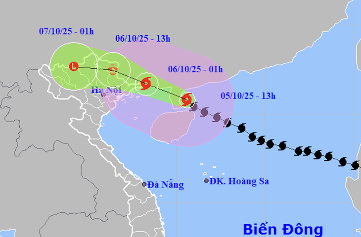
Forecast of location and direction of storm Matmo at 1:00 p.m. October 5 - Photo: NCHMF
Mr. Mai Van Khiem, Director of the National Center for Hydro-Meteorological Forecasting, said that at 1:00 p.m. on October 5, the center of storm Matmo was 290km east-southeast of Mong Cai ( Quang Ninh ).
The storm is currently at level 12-13 (118-149km/h), gusting to level 16. At this time, storm Matmo is at its strongest and is moving west-northwest at a speed of about 25km/h.
"This evening, the storm will pass the Leizhou peninsula (China) and enter the northern Gulf of Tonkin with an intensity of about level 12 (118-133km/h), gusting to level 15.
After entering the Gulf of Tonkin, the storm will move along the northern coast of the Gulf of Tonkin and is likely to make landfall between Quang Ninh (Vietnam) and Guangxi (China) around midnight tonight to early tomorrow morning," said Mr. Khiem.
According to Mr. Khiem, with the above direction and speed of movement, in the northern Gulf of Tonkin, there is a possibility of wind reaching level 12, gusting to level 15. Bach Long Vi and Co To islands are likely to have strong winds of level 8-9, the area near the storm's eye will have level 10-12, gusting to level 15, waves 2-4m high, the area near the storm's eye will have 3-5m.
"Boating and aquaculture activities along the coast of Quang Ninh, Hai Phong and Hung Yen need to be extremely careful because they may be affected by strong winds and big waves," Mr. Khiem emphasized.
For the mainland, Mr. Khiem said that the coastal areas of Quang Ninh and northern Hai Phong are forecast to be affected by strong winds of level 9-10 (75-102km/h), gusting to level 12.
The area of strong winds of level 8 (62-74km/h) may extend into the Lang Son area, especially the communes and wards bordering China. Deeper inland in the Northeast region, there may be strong winds of level 6-7, gusting to level 8-9.
Matmo's circulation is wide, so the period of strongest winds over land may last from tonight to tomorrow afternoon.
Mr. Mai Van Khiem, Director of the National Center for Hydro-Meteorological Forecasting, informs about the developments of storm Matmo - Video: H.LINH
In addition to strong winds at sea and on land, storm Matmo will also cause widespread heavy rain in the Northern provinces, focusing on the midland and mountainous provinces of the North, with rainfall ranging from 150-250mm, in some places over 400mm in the provinces of Quang Ninh, Lang Son, Cao Bang, Lao Cai, Tuyen Quang,...
In the Northern Delta region, rainfall is forecast to be 70-150mm, with some places over 200mm.
With such heavy rain, we need to be on guard against major floods on rivers in the North, possibly at alert level 2 - alert level 3, some places at alert level 3. At the same time, flood flow to reservoirs may increase from around October 6 to 9, we need to pay close attention to Thac Ba, Tuyen Quang, and Hoa Binh reservoirs..." - Mr. Khiem said.
Emphasizing the risk of flash floods and landslides, Mr. Khiem said that storm No. 10 (Bualoi) has caused very heavy rain in the midlands and mountainous areas of the North with average rainfall of 200-300mm, most mountainous areas of the North have had enough water, landslides have occurred in many places, and there is a potential risk of blockage in rivers and streams in the mountains.
Meanwhile, due to the impact of storm Matmo on October 6 and 7, heavy rain continues to occur in the North, leading to a very high risk of flash floods and landslides in mountainous and midland areas.
Local authorities need to review landslide-prone areas and evacuate people at blockage points to ensure safety.
4 provinces and cities have banned the sea
According to a quick report from the Border Guard Command as of 10:30 a.m. on October 5, this unit has notified and instructed nearly 68,000 ships with more than 292,000 workers to know the storm's developments so they can proactively avoid it.
Of which, 1,517 ships/6,279 workers are operating in the Gulf of Tonkin from Quang Ninh to Ha Tinh. The vehicles are moving back to shore.
As of this morning, the provinces and cities of Quang Ninh, Hai Phong, Hung Yen and Ninh Binh have banned the sea.
About 650,000 hectares of unharvested rice, 108,000 hectares of vegetables, nearly 87,000 hectares of perennial industrial crops and 455,000 hectares of fruit trees are at risk of being affected by storm Matmo.
In addition, the provinces and cities from Quang Ninh to Ninh Binh have nearly 100,000 hectares of saltwater and freshwater aquaculture, 23,200 cages and rafts, and 2,417 watchtowers that are also susceptible to storms.
Source: https://tuoitre.vn/hoan-luu-bao-matmo-rong-gio-manh-co-the-keo-dai-tu-dem-nay-den-trua-mai-20251005142721306.htm


![[Photo] Urgently help people soon have a place to live and stabilize their lives](/_next/image?url=https%3A%2F%2Fvphoto.vietnam.vn%2Fthumb%2F1200x675%2Fvietnam%2Fresource%2FIMAGE%2F2025%2F12%2F09%2F1765248230297_c-jpg.webp&w=3840&q=75)


![[Photo] General Secretary To Lam works with the Standing Committees of the 14th Party Congress Subcommittees](https://vphoto.vietnam.vn/thumb/402x226/vietnam/resource/IMAGE/2025/12/09/1765265023554_image.jpeg)


Comment (0)