
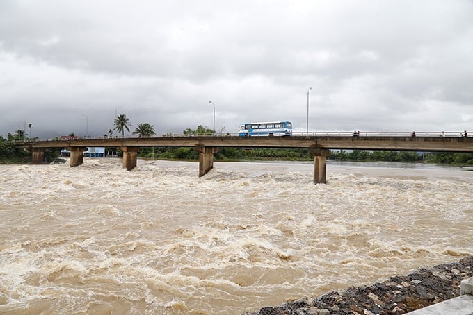
Floods on Cau River and Thuong River ( Bac Ninh ) are receding. Water levels at 1:00 p.m. on October 13 on the rivers are as follows:
On Thuong River at Phu Lang Thuong station 5.61m, 0.31m above alarm level 2;
On Cau River at Dap Cau station 4.86m, below alarm level 2 0.44m.
It is forecasted that in the next 12 hours, flood on Thuong River at Phu Lang Thuong station will continue to decrease and be below alert level 2.
In the next 12-24 hours, flood on Thuong River at Phu Lang Thuong station will continue to decrease and be above alert level 1.
In the next 24 hours, flood on Cau River at Dap Cau station will continue to decrease and is likely to be below alert level 1.
Flooding in Thai Nguyen, Bac Ninh provinces and Hanoi city will continue in riverside communes and wards, and in low-lying areas in the coming days; there is a risk of riverbank and dike erosion and landslides on slopes in the above areas.
Beware of flash floods and landslides due to heavy rain in Quang Tri province
Besides, in the past hour (from 13:00 to 14:00 on October 13), Quang Tri province had moderate and heavy rain such as Dakrong Hydropower Plant 64.8mm, La To Hydropower Dam 23.8mm...
Soil moisture models show that some areas in Quang Tri province are near saturation (over 85%) or have reached saturation.
It is forecasted that in the next 3-6 hours, Quang Tri province will continue to have rain with accumulated rainfall of 10-20mm, in some places over 40mm.
The meteorological agency warns that in the next 6 hours, beware of the risk of flash floods on small rivers and streams, landslides on steep slopes in Quang Tri province, especially in the communes/wards of Dakrong, Ba Long, Cam Lo, Con Tien, and La Lay.
Source: https://nhandan.vn/lu-tren-song-thuong-song-cau-tiep-tuc-xuong-post915038.html


![[Photo] Ready for the 2025 Fall Fair](https://vphoto.vietnam.vn/thumb/1200x675/vietnam/resource/IMAGE/2025/10/14/1760456672454_ndo_br_chi-9796-jpg.webp)


![[Photo] Ready for the 2025 Fall Fair](https://vphoto.vietnam.vn/thumb/402x226/vietnam/resource/IMAGE/2025/10/14/1760456672454_ndo_br_chi-9796-jpg.webp)


Comment (0)