

Commenting on the developments of storm Matmo, Associate Professor, Doctor, Director of the National Center for Hydro-Meteorological Forecasting Mai Van Khiem said that by October 4, the storm is forecast to be in the northern sea area of the North East Sea, about 750 km from Hoang Sa special zone, and is likely to strengthen.
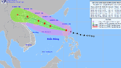
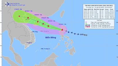
According to the National Center for Hydro-Meteorological Forecasting, at 7:00 a.m. on October 3, the center of the storm was located at about 16.3 degrees North latitude; 122.7 degrees East longitude, in the sea east of Luzon Island (Philippines). The strongest wind near the center of the storm was level 9-10 (75-102 km/h), gusting to level 13. Moving in the West Northwest direction at a speed of about 25 km/h.
Forecast, by 7am on October 4, the storm will be in the northern sea area of the North East Sea, about 750km southeast of Hoang Sa special zone with strong winds of level 10-11, gusting to level 14; moving in the West Northwest direction at a speed of 25km/h, entering the East Sea and likely to strengthen. The affected area is the eastern sea area of the North East Sea. Disaster risk level 3.
At 7:00 a.m. on October 5, the storm was in the northwest sea of the North East Sea, about 200km southeast of Leizhou Peninsula (China) with strong winds of level 12, gusts of level 15; moving in the West Northwest direction at a speed of about 20-25 km/h, and likely to continue to strengthen. The affected area is the northern sea of the North East Sea. Disaster risk level 3.
At 7:00 a.m. on October 6, the storm was in the Northeast region of the North with strong winds of level 10, gusts of level 13; moving in the West Northwest direction at a speed of about 20-25 km/h and entering the North Gulf of Tonkin and gradually weakening. The affected area is the Northwest sea area of the North East Sea and the North Gulf of Tonkin. Disaster risk level 3.
From the next 72 to 96 hours, the storm will move in the West Northwest direction, traveling 15-20 km per hour, and the storm's intensity will continue to weaken.
Due to the impact of the storm, from noon and afternoon on October 3, the eastern sea area of the North East Sea will have winds gradually increasing to level 6-7; then increasing to level 8-9, the area near the storm's center will have strong winds of level 10-11, gusting to level 13, waves 4-6m high, and very rough seas.
From October 4-5, the northern sea area of the North East Sea is likely to be affected by strong winds of level 11-12, gusts of level 15, waves 6-8m high, and rough seas.
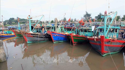
Vessels operating in the above mentioned dangerous areas are susceptible to the impact of storms, whirlwinds, strong winds and large waves.
Source: https://baodanang.vn/ngay-4-10-bao-matmo-nam-tren-khu-vuc-bac-bien-dong-va-co-the-manh-them-3305297.html

![[Photo] Prime Minister Pham Minh Chinh chairs meeting to deploy overcoming consequences of storm No. 10](https://vphoto.vietnam.vn/thumb/1200x675/vietnam/resource/IMAGE/2025/10/3/544f420dcc844463898fcbef46247d16)


![[Photo] Students of Binh Minh Primary School enjoy the full moon festival, receiving the joys of childhood](https://vphoto.vietnam.vn/thumb/1200x675/vietnam/resource/IMAGE/2025/10/3/8cf8abef22fe4471be400a818912cb85)


Comment (0)