The satellite device, designed by a British company, will measure the thermal performance of buildings and identify those contributing to the urban heat island effect in cities.
HotSat-1 satellite equipped with a sensor measuring thermal efficiency. Photo: Satellite Vu
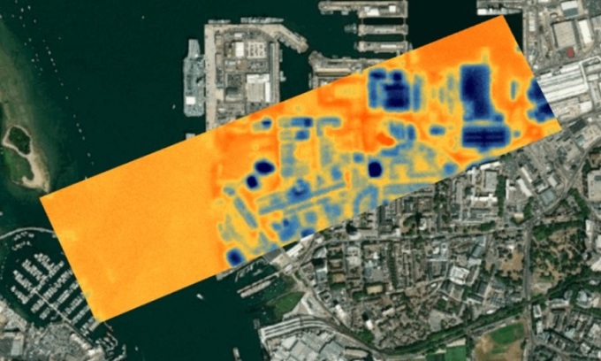
London-based start-up Satellite Vu launched a new satellite called HotSat-1 on June 12 that could help tackle the effects of global climate change. "We are introducing the first thermometer in the sky. Satellite Vu will launch a constellation of eight satellites that will measure the thermal efficiency of any building on the planet," said Anthony Baker, the company's chief executive. HotSat-1 is designed to provide high-resolution views of rooftops and walls of individual buildings while flying at an altitude of 500 kilometers.
To meet its 2050 net zero emissions target, the UK is making infrastructure changes to accelerate progress due to an inefficient housing stock and the vast majority of homes built before 1970. Using data from across the city, Satellite Vu can quickly highlight the 20% of buildings in the worst condition, and push for improvements to these properties.
HotSat-1 can identify structures and open spaces that exacerbate the urban heat island effect, including large parking lots in retail centers, which significantly increase temperatures in cities and towns. From there, urban planners can plan the most suitable places to plant trees and cool the environment.
HotSat-1 will also monitor pollution and detect sudden changes in river water temperature. The satellite’s sensors have been tested on planes flying over Ealing in London. The UK’s national mapping agency, Ordnance Survey (OS), will monitor the satellite’s data.
With global temperatures continuing to rise, NASA is also implementing the Applied Remote Sensing Training Program (ARSET) in 2022 to mitigate the effects of heat and develop a heat vulnerability index to reduce health risks for urban residents.
An Khang (According to Interesting Engineering )
Source link























![[Maritime News] More than 80% of global container shipping capacity is in the hands of MSC and major shipping alliances](https://vphoto.vietnam.vn/thumb/402x226/vietnam/resource/IMAGE/2025/7/16/6b4d586c984b4cbf8c5680352b9eaeb0)





















Comment (0)