
According to the National Center for Hydro-Meteorological Forecasting, early this morning (July 18), the tropical depression in the sea east of the Philippines has strengthened into a storm, internationally named Wipha. The strongest wind near the storm's center is level 8 (62-74km/h), gusting to level 10. Today, the storm is mainly moving northwest at a speed of about 20km/h and is likely to strengthen further.
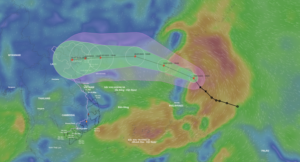
It is forecasted that tomorrow day and night, Typhoon Wipha will likely enter the East Sea and continue to strengthen. It is likely that this will be the third typhoon in 2025. From July 20-25, there is a possibility of widespread heavy rain in the Northern region.
To proactively respond to storm Wipha and widespread heavy rain and flooding, the Ministry of Agriculture and Environment requests ministries, branches, and People's Committees of provinces and cities in the Northern region and coastal areas from Quang Ninh to Dak Lak to closely monitor the storm's developments; strictly manage means of transport going out to sea; notify owners of means of transport, captains of ships and boats operating at sea of the location, direction of movement, and developments of the storm so that they can proactively avoid, escape, or not move into dangerous areas.
Review and implement safety measures for bridge and port works; tourism, aquaculture, and fishing activities at sea. Prepare safety measures, limit damage to houses, warehouses, headquarters, public works, industrial parks, factories, power grids, telecommunications systems; protect agricultural production; prevent flooding in urban areas and industrial parks. Proactively take measures to ensure safety of reservoirs, especially small, vulnerable reservoirs under construction; be ready to operate, regulate, and handle situations. Prepare forces and means for rescue when required.
Source: https://quangngaitv.vn/san-sang-luc-luong-phuong-tien-ung-pho-bao-wipha-6505029.html


![[Infographic] In 2025, 47 products will achieve national OCOP](https://vphoto.vietnam.vn/thumb/402x226/vietnam/resource/IMAGE/2025/7/16/5d672398b0744db3ab920e05db8e5b7d)


Comment (0)