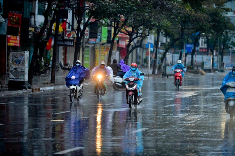
On the night of May 9 and 10, a cold air mass will move down to the North, causing widespread thunderstorms.
Head of Weather Forecast Department, National Center for Hydro-Meteorological Forecasting Nguyen Van Huong said that on the night of May 9 and May 10, a cold air mass will move down to the North, causing widespread thunderstorms, with some areas having heavy rain in the North and North Central regions.
The influence of cold air will reduce the hot weather in the North and North Central regions, and the temperature in these areas will also drop to around 27-29 degrees Celsius. On May 11, the above areas will experience heavy rain.
Commenting on the weather patterns from May 6-15, according to Mr. Nguyen Van Huong, on May 6, the Northern region will be sunny, with some places having hot weather, especially in the midlands and the Northern Delta, Son La and Hoa Binh provinces, which will have hot weather. The Northern mountainous region will have scattered showers and thunderstorms on the night of May 6.
Thanh Hoa - Phu Yen area, hot during the day, some places are very hot, in the evening and at night there are showers and thunderstorms in some places.
Other areas in the late afternoon and evening have scattered showers and thunderstorms, especially in the Central Highlands and the South, with sunny days and hot weather in some places. In the late afternoon and evening, there are scattered showers and thunderstorms, with heavy rain in some places.
From May 8-9, the Northern region will have hot weather, with some areas experiencing severe heat. From the evening of May 9-10, there will be scattered showers and thunderstorms, with some areas experiencing moderate to heavy rain.
From May 8-9, the area from Thanh Hoa to Phu Yen will be hot, with some places experiencing severe heat.
In the evening and night of May 9-10, the North Central region is likely to have scattered showers and thunderstorms, with some places having heavy rain. From May 11, the rain will gradually decrease.
In the evening of May 10-14, the Central and South Central regions are likely to have scattered showers and thunderstorms, with some places experiencing heavy rain. From May 15, the rain will gradually decrease.
The Central Highlands and the South have localized heat, scattered showers and thunderstorms in the late afternoon and evening, and locally heavy rain.
"Regions across the country need to be on guard against thunderstorms that may cause tornadoes, lightning, hail, and strong gusts of wind," Mr. Nguyen Van Huong warned.
Along with that, in May, heat waves tend to increase widely in the Northern and Central regions; in the Central Highlands and the Southern regions, heat waves appear locally; in the Southeast region, heat waves are concentrated in the first half of May 2025, then gradually decrease.
Nguyen Van Huong noted that cold air compressing the low pressure trough in the North could cause showers and thunderstorms in the Northern region. The Southwest monsoon in the South is likely to operate from around mid-May 2025, causing increased showers and thunderstorms in the Central Highlands and Southern regions.
According to hydrometeorological experts, thunderstorms, tornadoes, lightning, and hail pose a potential threat to people’s lives and property. Heat waves are likely to increase, leading to a high risk of drought, water shortages, and potential fire and explosion risks, especially in the Central region. This affects the lives and production of people in the region.
Localized heavy rains are likely to cause flash floods on small rivers and streams, landslides on steep slopes and waterlogging in low-lying areas.
Flash floods and landslides can have very negative impacts on the environment, threaten people's lives; cause local traffic congestion, affect the movement of vehicles; destroy civil and economic works, causing damage to production and socio-economic activities.
The hydrometeorological agency noted that people need to regularly monitor forecast and warning information on the website of the National Center for Hydro-Meteorological Forecasting at nchmf.gov.vn, provincial, municipal and regional Hydro-Meteorological Stations, and regularly update the latest hydro-meteorological forecast information on the official mass media of the Central and local levels to proactively respond, and at the same time recommend that local authorities in affected areas pay attention to reviewing the flow bottlenecks and vulnerable locations in the area to take preventive and response measures.
According to the guidance of the Department of Dyke Management and Natural Disaster Prevention and Control (Ministry of Agriculture and Environment), in the face of the above situation, affected areas should closely monitor developments of heavy rain, floods, flash floods, landslides, and promptly and fully inform authorities at all levels and people to proactively prevent, respond, and minimize damage.
Localities deploy shock forces to inspect and review residential areas along rivers, streams, and low-lying areas to proactively organize the relocation and evacuation of people in areas at high risk of deep flooding, flash floods, and landslides; organize forces ready to control and direct traffic, and place warning signs, especially through culverts, spillways, and areas with deep flooding and fast-flowing water; proactively arrange forces, materials, and means to overcome incidents, ensuring smooth traffic on main traffic routes when heavy rain occurs.
TC
Source: https://baochinhphu.vn/sap-co-dot-khong-khi-lanh-tran-xuong-phia-bac-102250506165147929.htm











Comment (0)