
 |
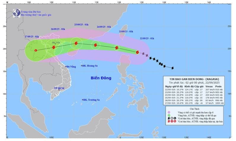
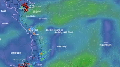
| Forecast map of super typhoon Ragasa's trajectory and intensity released at 2:00 a.m. on September 22. |
The strongest wind near the storm center is level 16-17 (184-221km/h), gusting above level 17. Moving in the West Northwest direction at a speed of about 20km/h.
Forecast for the next 24–72 hours, location: 20.2 degrees north latitude, 119.5 degrees east longitude, in the northeastern sea of the East Sea. Intensity: level 17, gusts above level 17.
Disaster risk: Level 4 - Eastern sea area of the North East Sea.
At 1:00 a.m. on September 24, location: 20.8 degrees north latitude, 114.8 degrees east longitude, in the northern part of the East Sea, about 490km east of Leizhou Peninsula (China). Intensity: level 16-17, gusts above level 17.
Disaster risk: Level 4 – northern sea area of the North East Sea.
Forecast at 1:00 a.m. on September 25, the storm's location is at 21.2 degrees north latitude, 110.5 degrees east longitude, in the sea east of Leizhou peninsula (China). Intensity: level 14-15, gusts above level 17, with a weakening tendency.
Natural disaster risk: Level 4 – Northwest sea area of the North East Sea; Eastern sea area of the Gulf of Tonkin.
Storm warning in the next 72-120 hours, the super storm is moving in the West Southwest direction, about 20km per hour, the intensity continues to weaken.
Storm impact warning, in the northeastern sea of the East Sea, winds will gradually increase to level 8-9, then increase to level 10-14.
The area near the center of the super storm is level 15-17, gusting above level 17, waves over 10m high, very rough seas.
Ships in the danger zone are susceptible to storms, whirlwinds, very strong winds and very large waves.
During the day and night of September 22, the eastern sea area of the North East Sea will have winds gradually increasing to level 8-9, then increasing to level 10-14; the area near the storm center will have strong winds of level 15-17, gusting above level 17. The sea will be rough, with waves 6-8m high, and over 10m near the storm center.
In the central East Sea area, the wind is level 5, sometimes level 6; at night it increases to level 6, gusting to level 7-8, rough sea, waves 2-3m high.
In the sea area from Khanh Hoa to Ho Chi Minh City and the sea area north of the South China Sea (including the north of Truong Sa special zone), wind level 5, sometimes level 6, gusting to level 7-8, rough sea, waves 2-3m high.
In addition, on the day and night of September 22, in the North and Central East Sea (including Hoang Sa), the North Gulf of Tonkin, the sea area from Gia Lai to Ca Mau will have scattered showers and thunderstorms; in the Northeast East Sea, there will be storms from the afternoon. During the thunderstorms, there is a possibility of tornadoes, gusts of wind of level 6-7 and waves over 2m high.
Source: https://huengaynay.vn/chinh-tri-xa-hoi/theo-dong-thoi-su/sieu-bao-ragasa-cap-16-17-tien-gan-bien-dong-158011.html

![[Photo] General Secretary attends the parade to celebrate the 80th anniversary of the founding of the Korean Workers' Party](https://vphoto.vietnam.vn/thumb/1200x675/vietnam/resource/IMAGE/2025/10/11/1760150039564_vna-potal-tong-bi-thu-du-le-duyet-binh-ky-niem-80-nam-thanh-lap-dang-lao-dong-trieu-tien-8331994-jpg.webp)

![[Photo] Ho Chi Minh City is brilliant with flags and flowers on the eve of the 1st Party Congress, term 2025-2030](https://vphoto.vietnam.vn/thumb/1200x675/vietnam/resource/IMAGE/2025/10/10/1760102923219_ndo_br_thiet-ke-chua-co-ten-43-png.webp)

![[Photo] Opening of the World Cultural Festival in Hanoi](https://vphoto.vietnam.vn/thumb/1200x675/vietnam/resource/IMAGE/2025/10/10/1760113426728_ndo_br_lehoi-khaimac-jpg.webp)


Comment (0)