
Last night (September 22), super typhoon Ragasa entered the East Sea, becoming the ninth typhoon of the year. It is forecasted that the typhoon will maintain a very fast speed of 20-25km/h, and tomorrow night (September 24) will cause heavy rain in the North of our country. From early morning of September 25, strong winds will begin to blow on land from Quang Ninh to Thanh Hoa.
This morning (September 23), the center of super typhoon Ragasa was about 840km east of Leizhou Peninsula (China) with the intensity of a level 17 super typhoon, gusting above level 17. Thus, Ragasa has surpassed typhoon Yagi in 2024 to become one of the strongest typhoons operating in the East Sea in the past few decades.
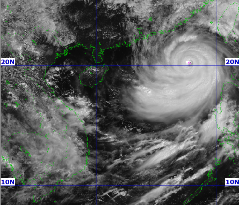
According to the National Center for Hydro-Meteorological Forecasting, the latest forecast models this morning show that storm Ragasa is moving very quickly when entering the East Sea with an average speed of 20-25km/h.
On September 23 and 24, the storm moved mainly in a west-northwest direction, towards the coastal waters of Guangdong province, China, then changed direction to the west-southwest, entering China's Leizhou peninsula on the night of September 24, and entering the Gulf of Tonkin on the morning of September 25.
In terms of intensity, the storm still maintains its super typhoon strength today and tonight (September 23). At 4:00 a.m. on September 24, while it was in the northern waters of the North East Sea, about 450km east of Leizhou Peninsula (China), Ragasa was still a super typhoon with a strength of level 16-17, gusting above level 17.
However, from September 24, the storm began to weaken as the storm's northern circulation began to rub against mainland China. It is forecast that by 4 a.m. on September 25, after passing through the Leizhou Peninsula and entering the Gulf of Tonkin, the storm will maintain an intensity of about level 12, gusting to level 15.
During the day and night of September 25, the storm moved quickly in a west-southwest direction, traveling about 20-25km per hour. Due to interaction with cold, dry air masses, the storm weakened quickly.
It is forecasted that around noon on September 25, the storm will begin to make landfall in Quang Ninh - Thanh Hoa with a possible intensity of level 10-11, gusting to level 13.
At 4am on September 26, the storm center in the Phu Tho - Son La area weakened into a tropical depression with an intensity of about level 6, gusting to level 8. The storm then continued to move to Laos, weakened into a low pressure area and gradually dissipated.
Due to the large cloud area and very fast moving speed, storm Ragasa affected our mainland very early. From early morning on September 25, the coastal mainland from Quang Ninh to Thanh Hoa had winds gradually increasing to level 6-7, then increasing to level 8, near the storm center level 9-10, gusting to level 12. The deep inland area of the Northeast had strong winds of level 6-7, gusting to level 8-9.
From the night of September 24 to September 26, the Northern region, Thanh Hoa and Nghe An will have heavy to very heavy rain with common rainfall of 100-250mm, some places over 400mm. Beware of heavy rain causing urban flooding as well as flash floods on small rivers and streams, landslides on steep slopes.
The meteorological agency also warned that due to the wide circulation of the storm, it is necessary to guard against the risk of thunderstorms, tornadoes and strong gusts of wind both before and during the storm's landfall, as happened with Yagi and typhoon Wipha, causing heavy damage.
In addition, the coastal areas of Quang Ninh-Hai Phong provinces have storm surges of 0.5-1.0m high. There is a high risk of landslides on sea dykes and embankments, destruction of aquaculture areas, ships and boats anchored along the coast due to strong winds, rising sea levels and big waves.
At sea, due to the influence of super typhoon Ragasa, the northern sea area of the North East Sea has strong winds of level 8-9, then increasing to level 10-14, the area near the center of the super typhoon has winds of level 15-17, gusts above level 17, waves over 10m high, and very rough seas.
From September 24, the eastern sea of Bac Bo Gulf (including Bach Long Vy island district) will have winds gradually increasing to level 6-7, gusting to level 9.
From the evening and night of September 24, the Bac Bo Gulf area (including Bach Long Vy, Van Don, Co To, Cat Hai and Hon Dau islands) will experience winds gradually increasing to level 8-9, waves 2-4m high, near the storm center will experience winds of level 10-12, gusts of level 14, waves 4-6m high, and very rough seas.
Source: https://cand.com.vn/Xa-hoi/sieu-bao-ragasa-di-chuyen-nhanh-trua-chieu-25-9-do-bo-vao-dat-lien-quang-ninh--thanh-hoa-i782192/
![[Photo] Closing of the 1st Congress of Party Delegates of Central Party Agencies](https://vphoto.vietnam.vn/thumb/1200x675/vietnam/resource/IMAGE/2025/9/24/b419f67738854f85bad6dbefa40f3040)


![[Photo] Editor-in-Chief of Nhan Dan Newspaper Le Quoc Minh received the working delegation of Pasaxon Newspaper](https://vphoto.vietnam.vn/thumb/1200x675/vietnam/resource/IMAGE/2025/9/23/da79369d8d2849318c3fe8e792f4ce16)


![[Photo] Solemn opening of the 1st Congress of Party Delegates of Central Party Agencies](https://vphoto.vietnam.vn/thumb/402x226/vietnam/resource/IMAGE/2025/9/24/82a89e250d4d43cbb6fcb312f21c5dd4)


Comment (0)