
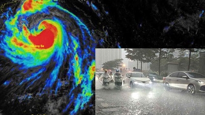
On August 17, the Northeast, Thanh Hoa and Nghe An are forecast to have moderate to heavy rain and thunderstorms with widespread rainfall of 50-120 mm, locally over 250 mm; in the northern mountainous region, 30-80 mm, some places over 150 mm. Ha Tinh and Quang Tri continue to have moderate to heavy rain (40-90 mm), locally very heavy rain over 200 mm. In addition, in the Northwest, Thua Thien Hue, the South Central Coast, the Central Highlands and the South, scattered showers and thunderstorms will occur, locally heavy to very heavy rain (10-30 mm, some places over 80 mm).
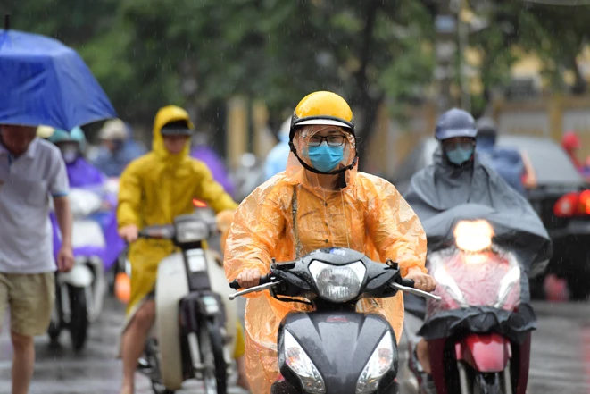
The North has moderate rain, heavy rain and thunderstorms.
Risk of heavy rain (>100 mm/3 hours) may occur at some locations, accompanied by dangerous weather phenomena such as tornadoes, lightning, hail and strong gusts of wind.
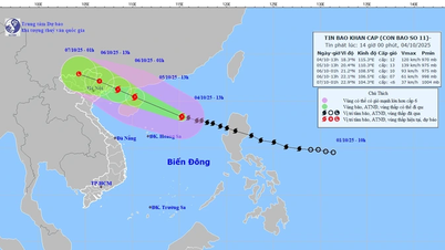
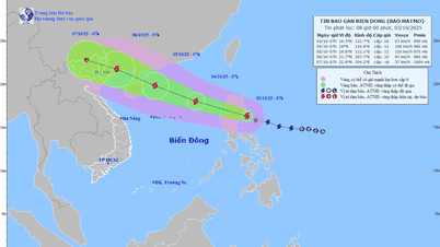
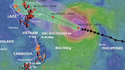
In the East Sea, at 1:00 a.m. on August 17, the center of the tropical depression was at about 16.7 degrees North latitude; 112.3 degrees East longitude, with the strongest wind force of level 6 (39-49 km/h), gusting to level 8, moving northwest at a speed of about 10 km/h. Strong southwest wind force of level 6, gusting to level 9-10 was recorded at Huyen Tran station; in Phu Quy area, there was strong southwest wind force of level 6, sometimes level 7, gusting to level 8; in Con Dao, there was strong gusting to level 7.
Forecast for the day and night of August 17, the sea area from Khanh Hoa to Ho Chi Minh City and the central and southern East Sea (including Truong Sa sea area) will have southwest wind level 6, gusting to level 7-8; waves 2-3.5 m high; rough sea. The sea area in the northwest of the East Sea (including Hoang Sa sea area) will have strong wind level 6-7, gusting to level 8-9; waves 2-3.5 m high; rough sea.
In addition, the Gulf of Tonkin, the sea area from South Quang Tri to Ca Mau, from Ca Mau to An Giang , the Gulf of Thailand and most of the East Sea will have showers and strong thunderstorms; during thunderstorms there is a possibility of tornadoes, strong gusts of wind, and waves over 3.5 m high.
Warning: In the Northern Gulf of Tonkin, there will be strong winds of level 6, gusts of level 7-8, waves 2-3 m high, and rough seas. Risk level of natural disasters due to strong winds at sea: from Khanh Hoa to Ho Chi Minh City level 2; in the Northwest of the East Sea (including Hoang Sa sea area) level 3.
Weather forecast for regions across the country:
Hanoi capital is cloudy with rain, moderate rain and thunderstorms, some places have heavy to very heavy rain. Northeast wind level 2-3. During thunderstorms, there is a possibility of tornadoes, lightning and strong gusts of wind. Lowest temperature 24-26 degrees Celsius. Highest temperature 30-32 degrees Celsius, some places above 32 degrees Celsius.
The Northwestern region is cloudy with scattered showers and thunderstorms, with some places experiencing heavy rain. Light winds. During thunderstorms, there is a possibility of tornadoes, lightning, hail and strong gusts of wind. The lowest temperature is 22-25 degrees Celsius, with some places below 21 degrees Celsius. The highest temperature is 29-32 degrees Celsius, with some places above 32 degrees Celsius.
The Northeastern provinces are cloudy with moderate to heavy rain and thunderstorms, with some places experiencing very heavy rain (heavy rain concentrated in the plains and coastal areas). Northeast wind level 2-3. During thunderstorms, there is a possibility of tornadoes, lightning, hail and strong gusts of wind. The lowest temperature is 22-25 degrees Celsius, in some places below 22 degrees Celsius. The highest temperature is 29-32 degrees Celsius, in some places above 32 degrees Celsius.
Provinces from Thanh Hoa to Hue will be cloudy with moderate rain, heavy rain and thunderstorms, locally very heavy rain; Thua Thien Hue will have rain, moderate rain and thunderstorms, locally heavy rain. North to northwest wind level 2-3. During thunderstorms, there is a possibility of tornadoes, lightning, hail and strong gusts of wind. Lowest temperature 22-25 degrees Celsius. Highest temperature 27-30 degrees Celsius.
The South Central Coast region in the North is cloudy with scattered showers and thunderstorms, some places have heavy rain; the South is cloudy with scattered showers and thunderstorms, especially in the late afternoon and evening there are scattered showers and thunderstorms. The wind is from the west to the southwest at level 2-3. During thunderstorms there is a possibility of tornadoes, lightning, hail and strong gusts of wind. The lowest temperature is 23-26 degrees Celsius. The highest temperature is 30-33 degrees Celsius, some places above 33 degrees Celsius.
The Central Highlands is cloudy with scattered showers and thunderstorms, with some places experiencing heavy rain (concentrated in the afternoon and evening). Southwesterly winds at level 2-3. During thunderstorms, there is a possibility of tornadoes, lightning, hail and strong gusts of wind. Lowest temperature 19-22 degrees Celsius. Highest temperature 27-30 degrees Celsius, some places above 30 degrees Celsius.
The South is cloudy with scattered showers and thunderstorms, with some places experiencing heavy rain (rain concentrated in the afternoon and evening). Southwesterly winds level 2-3. During thunderstorms, there is a possibility of tornadoes, lightning, hail and strong gusts of wind. Lowest temperature 24-26 degrees Celsius. Highest temperature 29-31 degrees Celsius, some places above 31 degrees Celsius.
Ho Chi Minh City is cloudy with scattered showers and thunderstorms, with some places experiencing heavy rain (concentrated in the afternoon and evening). Southwesterly winds at level 2-3. During thunderstorms, there is a possibility of tornadoes, lightning, hail and strong gusts of wind. Lowest temperature 24-26 degrees Celsius. Highest temperature 30-32 degrees Celsius.
Source baotintuc.vn
Source: https://baophutho.vn/thoi-weather-ngay-17-8-mua-lon-dien-rong-ap-thap-nhiet-doi-tren-bien-dong-238042.htm
![[Photo] Bustling Mid-Autumn Festival at the Museum of Ethnology](https://vphoto.vietnam.vn/thumb/1200x675/vietnam/resource/IMAGE/2025/10/4/da8d5927734d4ca58e3eced14bc435a3)


![[Photo] Solemn opening of the 8th Congress of the Central Public Security Party Committee, term 2025-2030](https://vphoto.vietnam.vn/thumb/1200x675/vietnam/resource/IMAGE/2025/10/4/f3b00fb779f44979809441a4dac5c7df)

![[Photo] General Secretary To Lam attends the 8th Congress of the Central Public Security Party Committee](https://vphoto.vietnam.vn/thumb/1200x675/vietnam/resource/IMAGE/2025/10/4/79fadf490f674dc483794f2d955f6045)


![[VIDEO] Summary of Petrovietnam's 50th Anniversary Ceremony](https://vphoto.vietnam.vn/thumb/402x226/vietnam/resource/IMAGE/2025/10/4/abe133bdb8114793a16d4fe3e5bd0f12)

![[VIDEO] GENERAL SECRETARY TO LAM AWARDS PETROVIETNAM 8 GOLDEN WORDS: "PIONEER - EXCELLENT - SUSTAINABLE - GLOBAL"](https://vphoto.vietnam.vn/thumb/402x226/vietnam/resource/IMAGE/2025/7/23/c2fdb48863e846cfa9fb8e6ea9cf44e7)


Comment (0)