
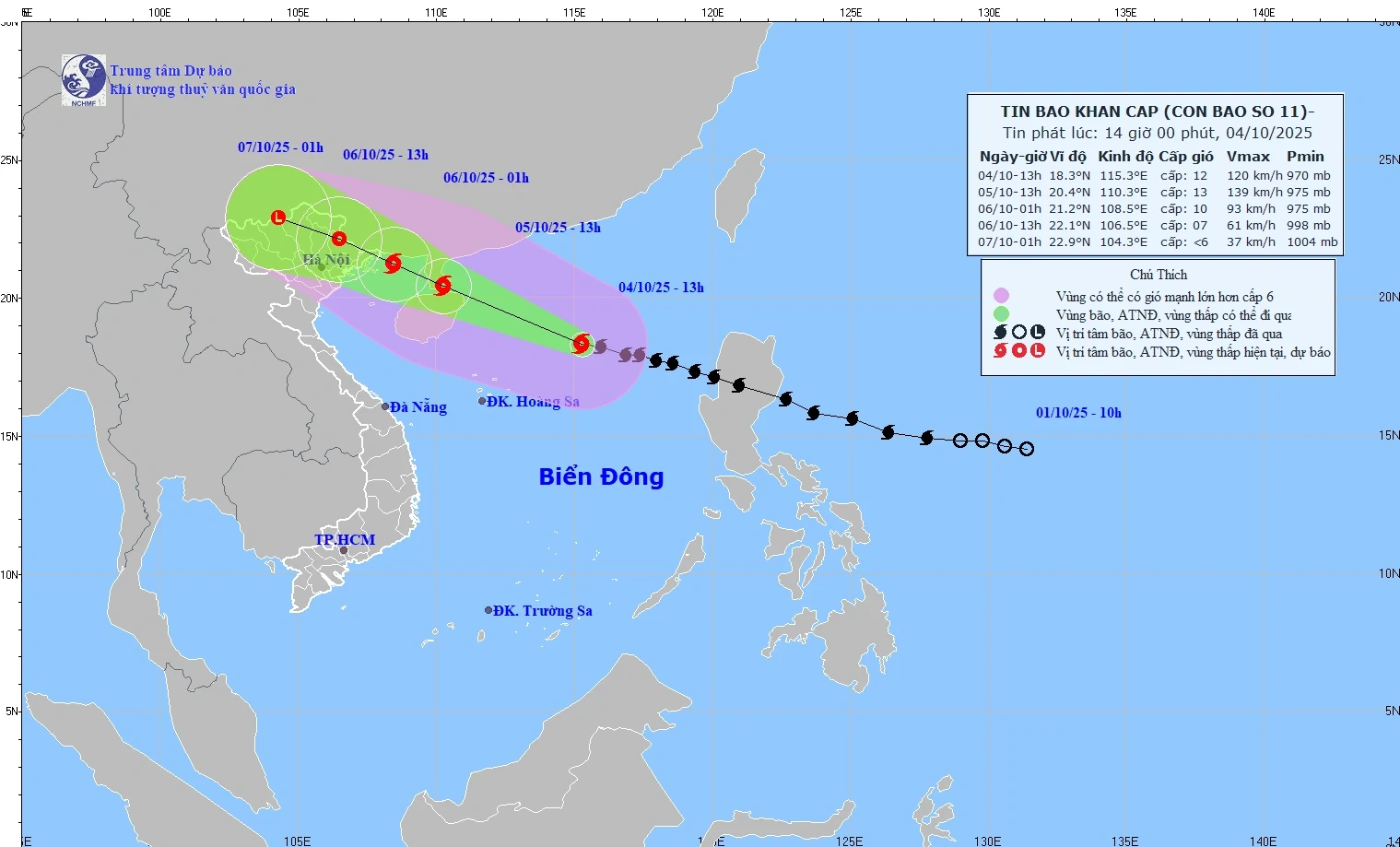
The movement direction of storm No. 11 (storm Matmo). Source: National Center for Hydro-Meteorological Forecasting
Commenting on storm No. 11 (storm Matmo), Head of Weather Forecasting Department Nguyen Van Huong said that currently (at 1:00 p.m.) on October 4, the eye of the storm is located in the North East Sea, 50km from Hainan Island (China), the strongest wind near the eye of the storm is level 11-12, gusting to level 15.
According to the forecast of the National Center for Hydro-Meteorological Forecasting, the storm's path in the coming time is likely to shift to the North. Thus, moving in this direction, the storm will enter the area between Quang Ninh and Guangxi (China).
When entering this area (around the afternoon of October 6), the strongest wind intensity will be level 8-9 for Quang Ninh province (down 3 levels and this may be the strongest wind level in Quang Ninh province); other areas such as Lang Son, old Bac Giang will have strong winds of level 6-7; the storm will gradually weaken.
“Storm No. 11 has a wide circulation, so even though the storm has not yet entered and has not had a direct impact, thunderstorms still appear before the storm, causing a huge impact on people and houses, mainly in the Gulf of Tonkin and the North,” Mr. Nguyen Van Huong noted.
In addition, due to the influence of the storm circulation, from the night of October 5-7, the mountainous and midland areas of the North will have heavy rain, with rainfall ranging from 150-250mm, and locally over 400mm. There is a risk of heavy rain with an intensity of over 150mm in 3 hours. The Northern Delta and Thanh Hoa areas will have moderate to heavy rain with rainfall ranging from 70-150mm, and locally over 200mm.
Hanoi area is less likely to be affected by storms. It is forecasted that from early morning of October 6 to the end of October 7, Hanoi will have moderate to heavy rain, with common rainfall of 70-120mm, locally over 150mm.
Explaining why the storm tends to strengthen when entering the East Sea, Mr. Nguyen Van Huong analyzed that it is because the storm has relatively favorable conditions during its movement, such as the sea surface temperature in the East Sea area of about 28-29 degrees Celsius (in which 26-27 degrees Celsius is a good condition for the storm to strengthen). In addition, the wind shear in the East Sea area is also small, creating a small amount of moisture to accumulate and develop in the structure of the storm.
Therefore, in the next 24 hours, the storm tends to strengthen, however, when moving past the northern area of Leizhou Island (China) and entering the Gulf of Tonkin, due to the storm's friction with the ground and increased wind shear in this area, the storm's intensity tends to decrease.
Source: VNA/Vietnam+
Source: https://baophutho.vn/bao-so-11-kha-nang-lech-len-phia-bac-de-phong-dong-loc-truoc-bao-240620.htm


![[Photo] The Standing Committee of the Organizing Subcommittee serving the 14th National Party Congress meets on information and propaganda work for the Congress.](https://vphoto.vietnam.vn/thumb/1200x675/vietnam/resource/IMAGE/2025/11/19/1763531906775_tieu-ban-phuc-vu-dh-19-11-9302-614-jpg.webp)

![[Photo] Prime Minister Pham Minh Chinh and his wife meet the Vietnamese community in Algeria](https://vphoto.vietnam.vn/thumb/1200x675/vietnam/resource/IMAGE/2025/11/19/1763510299099_1763510015166-jpg.webp)


![[Photo] General Secretary To Lam receives Slovakian Deputy Prime Minister and Minister of Defense Robert Kalinak](https://vphoto.vietnam.vn/thumb/1200x675/vietnam/resource/IMAGE/2025/11/18/1763467091441_a1-bnd-8261-6981-jpg.webp)
![[Photo] General Secretary To Lam receives CEO of AP Moller-Maersk Group, Denmark](https://vphoto.vietnam.vn/thumb/1200x675/vietnam/resource/IMAGE/2025/11/18/1763462288958_a3-bnd-8222-2510-jpg.webp)


Comment (0)