

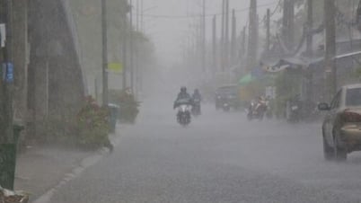
On the morning of August 28, heavy rain occurred in many places, from Thanh Hoa to Lam Dong . Some stations recorded rainfall of over 90mm, typically: Khe Na 1 station (Nghe An) 114.4mm; Viet Trung station (Quang Tri) 96.4mm; Dien Binh station (Quang Ngai) 94.6mm.
According to the forecast, in the next 24 hours, from Thanh Hoa to Lam Dong and the Southern region, there will continue to be scattered showers and thunderstorms, with rainfall ranging from 10 to 30mm, with some places receiving over 80mm. There is a risk of heavy rain with an intensity of over 80mm in 3 hours, accompanied by tornadoes, lightning, hail and strong gusts of wind. These extreme phenomena can cause flash floods on small rivers and streams and landslides in mountainous areas.
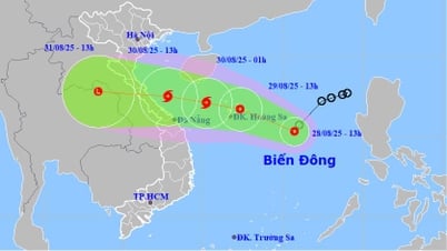
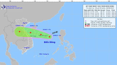
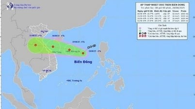
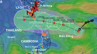
At sea, at 1:00 a.m. on August 28, the center of the tropical depression was at about 17.2 degrees North latitude; 117.4 degrees East longitude, in the northeastern waters of the East Sea. The strongest wind near the center of the tropical depression reached level 6 (39 - 49 km/h), gusting to level 8. It is forecasted that in the next 24 hours, the tropical depression will move in a West-Southwest direction at a speed of 10 - 15 km/h.
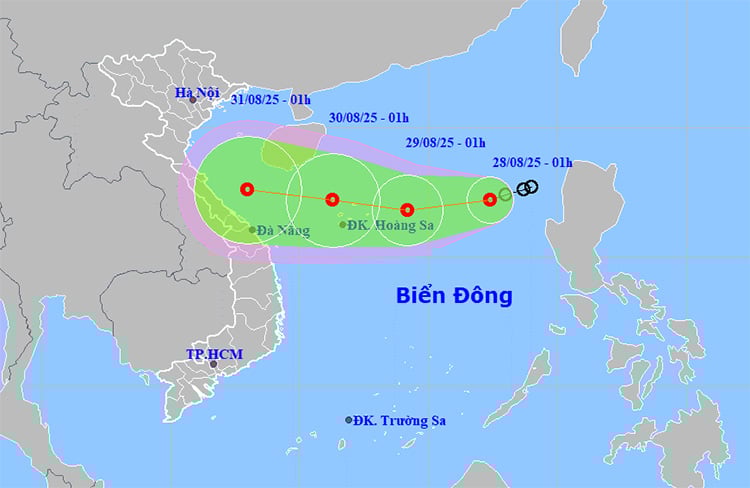 |
| Location and path of the tropical depression. Photo: thoitietvietnam |
Currently, the southwest wind is strong in many places: Huyen Tran station recorded wind level 6, gust level 9; Truong Sa station had wind level 7. During the day and night of August 28, the sea area from Binh Thuan to Ho Chi Minh City, the central and southern East Sea area (including Truong Sa sea area) had strong southwest wind level 6, gust level 7 - 8, waves 2 - 3.5m high, rough sea. In the east of the northern East Sea area, strong wind level 6 - 7, gust level 9, waves 2 - 4m high, rough sea.
The meteorological agency warned that the risk of natural disasters due to strong winds at sea is at level 2, and the northeastern part of the East Sea is at level 3. All ships operating in the area need to closely monitor forecasts and proactively take shelter to ensure safety.
Weather forecast for regions across the country:
Hanoi capital is cloudy, sunny during the day, sometimes with showers and thunderstorms at night. Light wind. During thunderstorms, there is a possibility of tornadoes, lightning, hail and strong gusts of wind. Lowest temperature 24 - 26 degrees Celsius. Highest temperature 31 - 33 degrees Celsius.
The Northwestern region is cloudy, with scattered showers and thunderstorms during the day and scattered showers and thunderstorms at night. Light winds. There is a possibility of tornadoes, lightning, hail and strong gusts of wind during thunderstorms. The lowest temperature is 22 - 25 degrees Celsius, with some places below 21 degrees Celsius. The highest temperature is 28 - 31 degrees Celsius, with some places above 31 degrees Celsius.
The Northeastern provinces are cloudy with scattered showers and thunderstorms. Light winds. Thunderstorms are likely to bring tornadoes, lightning, hail and strong gusts of wind. Lowest temperature 23 - 26 degrees Celsius. Highest temperature 30 - 33 degrees Celsius.
Provinces from Thanh Hoa to Hue will be cloudy with scattered showers and thunderstorms, with scattered showers and thunderstorms in the late afternoon and evening, with some heavy rain in some places. Light wind. There is a possibility of tornadoes, lightning and strong gusts of wind in thunderstorms. Lowest temperature 23-26 degrees Celsius. Highest temperature 29-32 degrees Celsius, with some places above 32 degrees Celsius.
The South Central Coast region is cloudy with scattered showers and thunderstorms; in the late afternoon and evening there will be scattered showers and thunderstorms, with some places having heavy rain. Southwesterly winds level 2-3. There is a possibility of tornadoes, lightning, hail and strong gusts of wind during thunderstorms. Lowest temperature 25-28 degrees Celsius. Highest temperature 31-34 degrees Celsius.
The Central Highlands is cloudy with scattered showers and thunderstorms; in the afternoon and evening there will be scattered showers and thunderstorms, with some places experiencing heavy rain. Southwesterly winds level 2-3. There is a possibility of tornadoes, lightning, hail and strong gusts of wind during thunderstorms. The lowest temperature is 19-22 degrees Celsius. The highest temperature is 27-30 degrees Celsius, with some places above 30 degrees Celsius.
The South is cloudy with scattered showers and thunderstorms; in the afternoon and evening there will be scattered showers and thunderstorms, with some places having heavy rain. Southwesterly winds level 2-3. There is a possibility of tornadoes, lightning, hail and strong gusts of wind during thunderstorms. Lowest temperature 24-27 degrees Celsius. Highest temperature 30-33 degrees Celsius, some places above 33 degrees Celsius.
Ho Chi Minh City is cloudy with scattered showers and thunderstorms; in the afternoon and evening there will be scattered showers and thunderstorms, with some heavy rain in some places. Southwesterly winds level 2-3. During thunderstorms there is a possibility of tornadoes, lightning, hail and strong gusts of wind. Lowest temperature 24-26 degrees Celsius. Highest temperature 31-33 degrees Celsius.
Source: https://huengaynay.vn/chinh-tri-xa-hoi/thoi-weather-ngay-28-8-ap-thap-nhiet-doi-gay-bien-dong-manh-o-bien-dong-157204.html
![[Photo] Red flag with yellow star flutters in France on National Day September 2](https://vphoto.vietnam.vn/thumb/1200x675/vietnam/resource/IMAGE/2025/8/28/f6fc12215220488bb859230b86b9cc12)

![[Photo] National Assembly Chairman Tran Thanh Man holds talks with New Zealand Parliament Chairman](https://vphoto.vietnam.vn/thumb/1200x675/vietnam/resource/IMAGE/2025/8/28/c90fcbe09a1d4a028b7623ae366b741d)
![[Photo] General Secretary To Lam attends the opening ceremony of the National Achievements Exhibition](https://vphoto.vietnam.vn/thumb/1200x675/vietnam/resource/IMAGE/2025/8/28/d371751d37634474bb3d91c6f701be7f)

![[Photo] Politburo works with the Standing Committee of Cao Bang Provincial Party Committee and Hue City Party Committee](https://vphoto.vietnam.vn/thumb/1200x675/vietnam/resource/IMAGE/2025/8/28/fee8a847b1ff45188749eb0299c512b2)


Comment (0)