
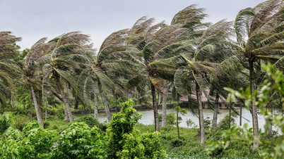
The Southern Hydrometeorological Station forecasts the general weather in Ho Chi Minh City and the South today (July 22), with variable clouds to cloudy, rain in many places and scattered thunderstorms, locally moderate to heavy rain. During thunderstorms, be on guard against thunder, strong gusts of wind and tornadoes, with occasional light sunshine during the day.
Lowest temperature from 24-27 degrees Celsius and highest from 29-32 degrees Celsius.

Weather at sea
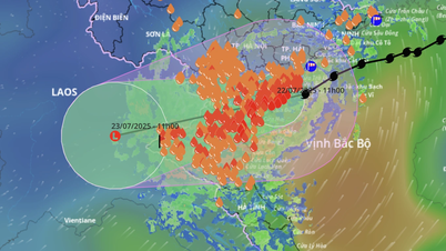
Due to the influence of storm No. 3, the weather in the sea area from Lam Dong to Ca Mau (including the sea area of Ho Chi Minh City) is Southwest wind level 5, sometimes level 6, gusting to level 7-8, especially Lam Dong level 6 gusting to level 7-8; wave height 2-4m, rough to strong sea. In addition, the sea area from Ca Mau - An Giang and Phu Quoc is Southwest wind level 4, sometimes level 5; wave height 0.75-2m, normal sea, sometimes slightly rough.
In both coastal areas, the weather will have scattered showers and thunderstorms. During thunderstorms, be on guard against tornadoes and strong gusts of wind of level 7-8.
What to note when storm number 3 affects the weather in the South?
According to the weather forecast agency, storm No. 3 (Wipha) will mainly cause very heavy rain and strong winds in the Northern and North Central regions. For the Southern region, storm No. 3 will have an indirect impact, mainly causing showers and thunderstorms, along with the risk of tornadoes, lightning and strong gusts of wind.
Therefore, people should limit going out during thunderstorms; be careful when traveling on the road, especially when there are strong winds or heavy rains that reduce visibility; ensure outdoor items are securely secured to avoid being blown away by the wind; seek safe shelter during thunderstorms, find solid shelter, away from large trees or electric poles.
Source: https://ttbc-hcm.gov.vn/thoi-tiet-tp-hcm-co-mua-dong-do-anh-huong-gian-tiep-tu-bao-so-3-1019195.html


Comment (0)